El Arenal elevation
El Arenal (Veracruz, Espinal), Mexico elevation is 136 meters and El Arenal elevation in feet is 446 ft above sea level [src 1]. El Arenal is a populated place (feature code) with elevation that is 1178 meters (3865 ft) smaller than average city elevation in Mexico.
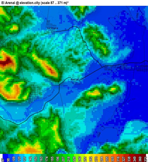
Below is the Elevation map of El Arenal, which displays elevation range with different colors. Scale of the first map is from 87 to 371 m (285 to 1217 ft) with average elevation of 144.8 meters (=475 ft) [note 1]
These maps also provides idea of topography and contour of this city, they are displayed at different zoom levels. More info about maps, scale and edge coordinates you can find below images.
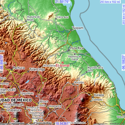
| \ | Map #1 | Topo.Map |
| Scale [m] | 87..371 m | × |
| Scale [ft] | 285..1217 ft | × |
| Average | 144.8 m = 475 ft | × |
| Width | 9.17 km = 5.7 mi | 293.3 km = 182.2 mi |
| Height | 9.17 km = 5.7 mi | 293.4 km = 182.3 mi |
| ↑Max Latitude | 20.309509° | 21.58176° |
| Latitude at center | 20.26829° | 20.26829° |
| ↓Min Latitude | 20.22706° | 18.94361° |
| ← Min Longitude | -97.636445° | -98.99875° |
| Longitude center | -97.5925° | -97.5925° |
| →Max Longitude | -97.548555° | -96.18625° |
Nearby cities:
Cities around El Arenal sort by population:
• Coyutla elevation 161 m
7.2 km,  251°
251°
• Entabladero 95 m
4.4 km,  79°
79°
• Las Lomas 145 m
2.5 km, 250°
• Chumatlán 399 m
7 km,  181°
181°
• Ricardo Flores Magón 335 m
8.9 km,  198°
198°
• Lázaro Cárdenas (Santana) 130 m
4.8 km, 180°
• La Colonia Guadalupe 149 m
9 km,  339°
339°
• El Panorama 159 m
5.1 km,  297°
297°
• Sabanas de Xalostoc 103 m
7.9 km,  130°
130°
• El Arenal 82 m
8.2 km,  102°
102°
• Rancho Alegre 464 m
8.3 km,  215°
215°
• San Leoncio Jamaya 120 m
5.1 km,  13°
13°
Multilingual:
 En español:
El Arenal elevación 136 m.
 En France:
El Arenal élévation 136 m.
 Auf Deutsch:
El Arenal höhe über dem Meeresspiegel ist 136 m.

Sources and notes:
- [note 1] Map square and city borders are not equal. Map elevation data is calculated only from area inside that square.
- [src 1] Elevation data from geonames database provided with same terms of usage.
- [src 2] The elevation map of El Arenal is generated using elevation data from NASA's 3 arcsec (90m) resolution SRTM data.
- [src 3] Base (background) map © OpenStreetMap contributors tiles are generated by Geofabrik and OpenTopoMap.
Copyright & License:
This El Arenal Elevation Map is licensed under CC BY-SA. You may reuse any part from this page, if you give a proper credit by linking to this URL:
 More info on terms of use page.