Coyutla elevation
Coyutla (Veracruz), Mexico elevation is 161 meters and Coyutla elevation in feet is 528 ft above sea level [src 1]. Coyutla is a seat of a second-order administrative division (feature code) with elevation that is 1153 meters (3783 ft) smaller than average city elevation in Mexico.
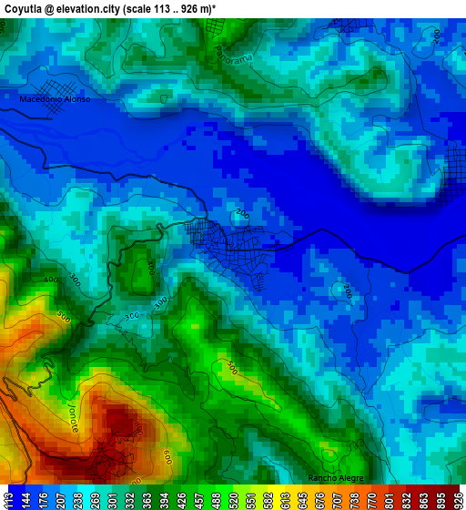
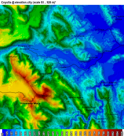
Below is the Elevation map of Coyutla, which displays elevation range with different colors. Scale of the first map is from 113 to 926 m (371 to 3038 ft) with average elevation of 300.1 meters (=985 ft) [note 1]
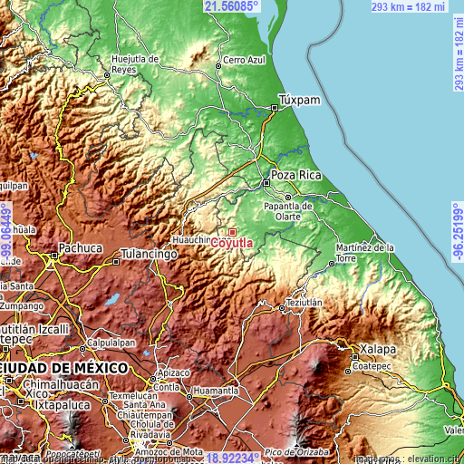
These maps also provides idea of topography and contour of this city, they are displayed at different zoom levels. More info about maps, scale and edge coordinates you can find below images.
| \ | Map #1 | Map #2 | Topo.Map |
| Scale [m] | 113..926 m | 93..926 m | × |
| Scale [ft] | 371..3038 ft | 305..3038 ft | × |
| Average | 300.1 m = 985 ft | 320 m = 1050 ft | × |
| Width | 9.17 km = 5.7 mi | 18.34 km = 11.4 mi | 293.4 km = 182.3 mi |
| Height | 9.17 km = 5.7 mi | 18.34 km = 11.4 mi | 293.4 km = 182.3 mi |
| ↑Max Latitude | 20.288424° | 20.329638° | 21.56085° |
| Latitude at center | 20.2472° | 20.2472° | 20.2472° |
| ↓Min Latitude | 20.205965° | 20.164718° | 18.92234° |
| ← Min Longitude | -97.702185° | -97.746131° | -99.06449° |
| Longitude center | -97.65824° | -97.65824° | -97.65824° |
| →Max Longitude | -97.614295° | -97.570349° | -96.25199° |
Nearby cities:
Cities around Coyutla sort by population:
• Filomeno Mata elevation 705 m
7.1 km,  222°
222°
• Mecatlán 855 m
4.8 km,  211°
211°
• Coahuitlán 641 m
7.6 km,  281°
281°
• Progreso de Zaragoza 182 m
6.4 km,  298°
298°
• Macedonio Alonso 176 m
4.6 km,  310°
310°
• Las Lomas 145 m
4.7 km,  71°
71°
• Ricardo Flores Magón 335 m
7.3 km,  146°
146°
• Lázaro Cárdenas (Santana) 130 m
7.2 km,  109°
109°
• El Arenal 136 m
7.2 km, 71°
• Cerro Grande 326 m
2.7 km,  248°
248°
• El Panorama 159 m
5.2 km,  26°
26°
• Rancho Alegre 464 m
4.9 km,  155°
155°
Multilingual:
 En español:
Coyutla elevación 161 m.
 En France:
Coyutla élévation 161 m.


Sources and notes:
- [note 1] Map square and city borders are not equal. Map elevation data is calculated only from area inside that square.
- [src 1] Elevation data from geonames database provided with same terms of usage.
- [src 2] The elevation map of Coyutla is generated using elevation data from NASA's 3 arcsec (90m) resolution SRTM data.
- [src 3] Base (background) map © OpenStreetMap contributors tiles are generated by Geofabrik and OpenTopoMap.
Copyright & License:
This Coyutla Elevation Map is licensed under CC BY-SA. You may reuse any part from this page, if you give a proper credit by linking to this URL:
 More info on terms of use page.