Cuautlapán elevation
Cuautlapán (Veracruz, Ixtaczoquitlán), Mexico elevation is 998 meters and Cuautlapán elevation in feet is 3274 ft above sea level [src 1]. Cuautlapán is a populated place (feature code) with elevation that is 316 meters (1037 ft) smaller than average city elevation in Mexico.
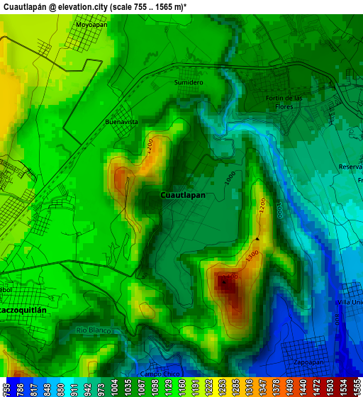
Below is the Elevation map of Cuautlapán, which displays elevation range with different colors. Scale of the first map is from 755 to 1565 m (2477 to 5135 ft) with average elevation of 1057.4 meters (=3469 ft) [note 1]
These maps also provides idea of topography and contour of this city, they are displayed at different zoom levels. More info about maps, scale and edge coordinates you can find below images.
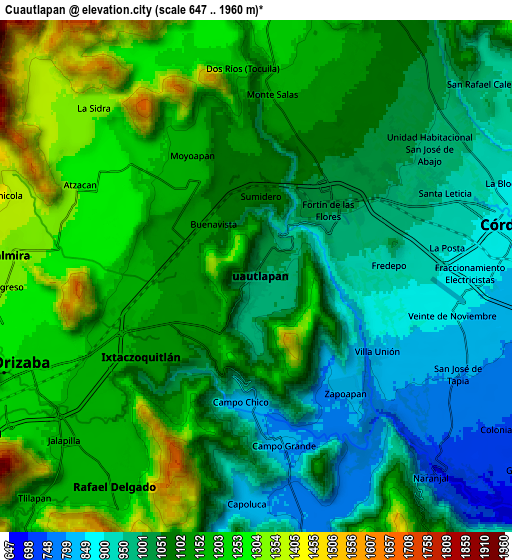
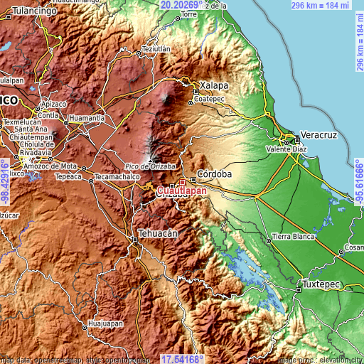
| \ | Map #1 | Map #2 | Topo.Map |
| Scale [m] | 755..1565 m | 647..1960 m | × |
| Scale [ft] | 2477..5135 ft | 2123..6430 ft | × |
| Average | 1057.4 m = 3469 ft | 1097.4 m = 3600 ft | × |
| Width | 9.25 km = 5.7 mi | 18.49 km = 11.5 mi | 295.9 km = 183.9 mi |
| Height | 9.25 km = 5.7 mi | 18.49 km = 11.5 mi | 295.9 km = 183.9 mi |
| ↑Max Latitude | 18.919046° | 18.960613° | 20.20269° |
| Latitude at center | 18.87747° | 18.87747° | 18.87747° |
| ↓Min Latitude | 18.835883° | 18.794286° | 17.54168° |
| ← Min Longitude | -97.066855° | -97.110801° | -98.42916° |
| Longitude center | -97.02291° | -97.02291° | -97.02291° |
| →Max Longitude | -96.978965° | -96.935019° | -95.61666° |
Nearby cities:
Cities around Cuautlapán sort by population:
• Ixtaczoquitlán elevation 1146 m
4.9 km,  237°
237°
• Fortín de las Flores 1048 m
4.2 km,  35°
35°
• El Pueblito 936 m
5.7 km,  79°
79°
• Sumidero 1080 m
2.9 km,  2°
2°
• Colorines 939 m
4.8 km, 80°
• Zapoapan 806 m
5.2 km,  142°
142°
• Fredepo 926 m
4.8 km,  85°
85°
• Buenavista 1102 m
2.3 km,  319°
319°
• Moyoapan 1185 m
5 km,  331°
331°
• Campo Chico 818 m
4.6 km,  186°
186°
• Fraccionamiento Villas de la Llave 1048 m
5.4 km, 38°
• Villa Unión 843 m
5 km,  121°
121°
Multilingual:
 En español:
Cuautlapán elevación 998 m.
 En France:
Cuautlapán élévation 998 m.
 Auf Deutsch:
Cuautlapán höhe über dem Meeresspiegel ist 998 m.

Sources and notes:
- [note 1] Map square and city borders are not equal. Map elevation data is calculated only from area inside that square.
- [src 1] Elevation data from geonames database provided with same terms of usage.
- [src 2] The elevation map of Cuautlapán is generated using elevation data from NASA's 3 arcsec (90m) resolution SRTM data.
- [src 3] Base (background) map © OpenStreetMap contributors tiles are generated by Geofabrik and OpenTopoMap.
Copyright & License:
This Cuautlapán Elevation Map is licensed under CC BY-SA. You may reuse any part from this page, if you give a proper credit by linking to this URL:
 More info on terms of use page.