El Pueblito elevation
El Pueblito (Veracruz), Mexico elevation is 936 meters and El Pueblito elevation in feet is 3071 ft above sea level [src 1]. El Pueblito is a section of populated place (feature code) with elevation that is 378 meters (1240 ft) smaller than average city elevation in Mexico.
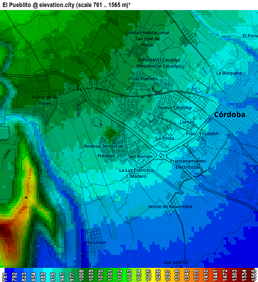
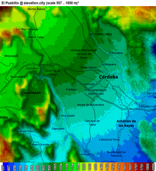
Below is the Elevation map of El Pueblito, which displays elevation range with different colors. Scale of the first map is from 761 to 1565 m (2497 to 5135 ft) with average elevation of 934.8 meters (=3067 ft) [note 1]
These maps also provides idea of topography and contour of this city, they are displayed at different zoom levels. More info about maps, scale and edge coordinates you can find below images.
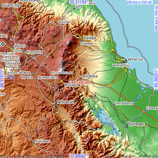
| \ | Map #1 | Map #2 | Topo.Map |
| Scale [m] | 761..1565 m | 557..1850 m | × |
| Scale [ft] | 2497..5135 ft | 1827..6070 ft | × |
| Average | 934.8 m = 3067 ft | 975.4 m = 3200 ft | × |
| Width | 9.25 km = 5.7 mi | 18.49 km = 11.5 mi | 295.9 km = 183.9 mi |
| Height | 9.25 km = 5.7 mi | 18.49 km = 11.5 mi | 295.9 km = 183.9 mi |
| ↑Max Latitude | 18.927964° | 18.969528° | 20.21154° |
| Latitude at center | 18.88639° | 18.88639° | 18.88639° |
| ↓Min Latitude | 18.844805° | 18.803211° | 17.55067° |
| ← Min Longitude | -97.013405° | -97.057351° | -98.37571° |
| Longitude center | -96.96946° | -96.96946° | -96.96946° |
| →Max Longitude | -96.925515° | -96.881569° | -95.56321° |
Nearby cities:
Cities around El Pueblito sort by population:
• Córdoba elevation 836 m
4.6 km,  93°
93°
• Fortín de las Flores 1048 m
4 km,  306°
306°
• Córdoba (Santa Leticia) 1010 m
2.7 km,  338°
338°
• Colorines 939 m
1 km,  258°
258°
• Fredepo 926 m
1 km,  230°
230°
• San José de Tapia 808 m
4.7 km,  159°
159°
• Veinte de Noviembre 861 m
2.8 km,  146°
146°
• Fraccionamiento Villas de la Llave 1048 m
4 km,  325°
325°
• San José de Abajo [Unidad Habitacional] 991 m
3.8 km,  9°
9°
• Villa Unión 843 m
3.8 km,  201°
201°
• Fraccionamiento los Álamos 1024 m
4.2 km,  351°
351°
• Trapiche Viejo 790 m
5.4 km, 152°
Multilingual:
 En español:
El Pueblito elevación 936 m.
 En France:
El Pueblito élévation 936 m.
 Auf Deutsch:
El Pueblito höhe über dem Meeresspiegel ist 936 m.

Sources and notes:
- [note 1] Map square and city borders are not equal. Map elevation data is calculated only from area inside that square.
- [src 1] Elevation data from geonames database provided with same terms of usage.
- [src 2] The elevation map of El Pueblito is generated using elevation data from NASA's 3 arcsec (90m) resolution SRTM data.
- [src 3] Base (background) map © OpenStreetMap contributors tiles are generated by Geofabrik and OpenTopoMap.
Copyright & License:
This El Pueblito Elevation Map is licensed under CC BY-SA. You may reuse any part from this page, if you give a proper credit by linking to this URL:
 More info on terms of use page.