Buenavista elevation
Buenavista (Veracruz, Ixtaczoquitlán), Mexico elevation is 1102 meters and Buenavista elevation in feet is 3615 ft above sea level [src 1]. Buenavista is a populated place (feature code) with elevation that is 212 meters (696 ft) smaller than average city elevation in Mexico.
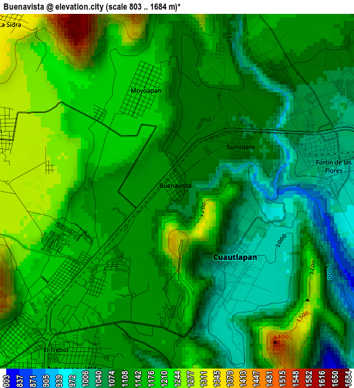
Below is the Elevation map of Buenavista, which displays elevation range with different colors. Scale of the first map is from 803 to 1684 m (2635 to 5525 ft) with average elevation of 1137.5 meters (=3732 ft) [note 1]
These maps also provides idea of topography and contour of this city, they are displayed at different zoom levels. More info about maps, scale and edge coordinates you can find below images.
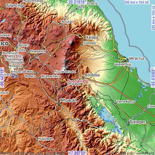
| \ | Map #1 | Topo.Map |
| Scale [m] | 803..1684 m | × |
| Scale [ft] | 2635..5525 ft | × |
| Average | 1137.5 m = 3732 ft | × |
| Width | 9.25 km = 5.7 mi | 295.8 km = 183.8 mi |
| Height | 9.25 km = 5.7 mi | 295.9 km = 183.9 mi |
| ↑Max Latitude | 18.934633° | 20.21816° |
| Latitude at center | 18.89306° | 18.89306° |
| ↓Min Latitude | 18.851477° | 17.55739° |
| ← Min Longitude | -97.080885° | -98.44319° |
| Longitude center | -97.03694° | -97.03694° |
| →Max Longitude | -96.992995° | -95.63069° |
Nearby cities:
Cities around Buenavista sort by population:
• Ixtaczoquitlán elevation 1146 m
5.1 km,  211°
211°
• Fortín de las Flores 1048 m
4.2 km,  66°
66°
• Córdoba (Santa Leticia) 1010 m
6.3 km, 74°
• Atzacan 1299 m
5.1 km,  287°
287°
• Cuautlapán 998 m
2.3 km,  139°
139°
• Dos Ríos 1220 m
5.9 km,  8°
8°
• Sumidero 1080 m
2 km,  53°
53°
• Colorines 939 m
6.2 km,  98°
98°
• Moyoapan 1185 m
2.8 km,  340°
340°
• Monte Salas 1180 m
5.3 km,  21°
21°
• Campo Chico 818 m
6.4 km,  171°
171°
• Fraccionamiento Villas de la Llave 1048 m
5.4 km,  62°
62°
Multilingual:
 En español:
Buenavista elevación 1102 m.
 En France:
Buenavista élévation 1102 m.
 Auf Deutsch:
Buenavista höhe über dem Meeresspiegel ist 1102 m.

Sources and notes:
- [note 1] Map square and city borders are not equal. Map elevation data is calculated only from area inside that square.
- [src 1] Elevation data from geonames database provided with same terms of usage.
- [src 2] The elevation map of Buenavista is generated using elevation data from NASA's 3 arcsec (90m) resolution SRTM data.
- [src 3] Base (background) map © OpenStreetMap contributors tiles are generated by Geofabrik and OpenTopoMap.
Copyright & License:
This Buenavista Elevation Map is licensed under CC BY-SA. You may reuse any part from this page, if you give a proper credit by linking to this URL:
 More info on terms of use page.