Ixtaczoquitlán elevation
Ixtaczoquitlán (Veracruz), Mexico elevation is 1146 meters and Ixtaczoquitlán elevation in feet is 3760 ft above sea level [src 1]. Ixtaczoquitlán is a seat of a second-order administrative division (feature code) with elevation that is 168 meters (551 ft) smaller than average city elevation in Mexico.
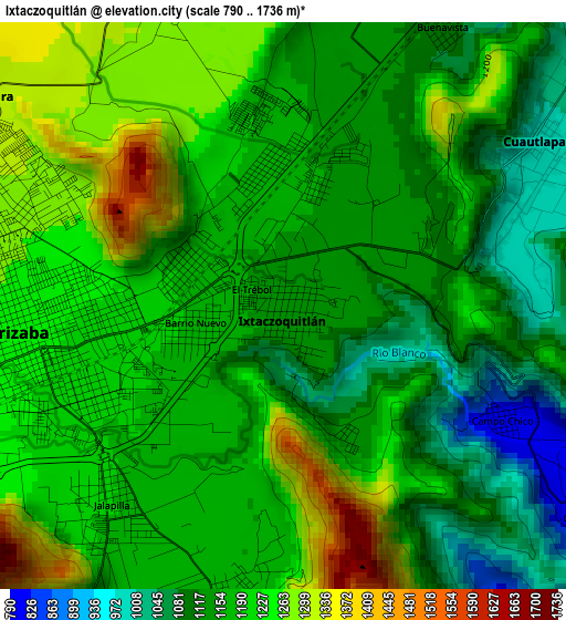
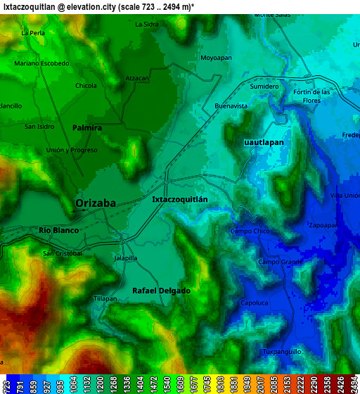
Below is the Elevation map of Ixtaczoquitlán, which displays elevation range with different colors. Scale of the first map is from 790 to 1736 m (2592 to 5696 ft) with average elevation of 1177.4 meters (=3863 ft) [note 1]
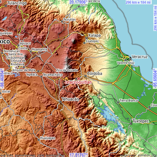
These maps also provides idea of topography and contour of this city, they are displayed at different zoom levels. More info about maps, scale and edge coordinates you can find below images.
| \ | Map #1 | Map #2 | Topo.Map |
| Scale [m] | 790..1736 m | 723..2494 m | × |
| Scale [ft] | 2592..5696 ft | 2372..8182 ft | × |
| Average | 1177.4 m = 3863 ft | 1254.6 m = 4116 ft | × |
| Width | 9.25 km = 5.7 mi | 18.5 km = 11.5 mi | 295.9 km = 183.9 mi |
| Height | 9.25 km = 5.7 mi | 18.5 km = 11.5 mi | 295.9 km = 183.9 mi |
| ↑Max Latitude | 18.895222° | 18.936794° | 20.17906° |
| Latitude at center | 18.85364° | 18.85364° | 18.85364° |
| ↓Min Latitude | 18.812047° | 18.770444° | 17.51767° |
| ← Min Longitude | -97.106235° | -97.150181° | -98.46854° |
| Longitude center | -97.06229° | -97.06229° | -97.06229° |
| →Max Longitude | -97.018345° | -96.974399° | -95.65604° |
Nearby cities:
Cities around Ixtaczoquitlán sort by population:
• Orizaba elevation 1238 m
3.9 km,  267°
267°
• Palmira 1343 m
6.1 km,  302°
302°
• Rafael Delgado 1171 m
4.9 km,  191°
191°
• Atzacan 1299 m
6.3 km,  339°
339°
• Jalapilla 1188 m
4.1 km,  222°
222°
• Unión y Progreso 1334 m
6.4 km,  289°
289°
• Cuautlapán 998 m
4.9 km,  57°
57°
• Fraccionamiento Valle Dorado 1325 m
6.5 km, 285°
• Campo Grande 800 m
6.2 km,  123°
123°
• Capoluca 813 m
6.4 km,  144°
144°
• Buenavista 1102 m
5.1 km,  31°
31°
• Campo Chico 818 m
4.1 km, 118°
Multilingual:
 En español:
Ixtaczoquitlán elevación 1146 m.
 En France:
Ixtaczoquitlán élévation 1146 m.
 Auf Deutsch:
Ixtaczoquitlán höhe über dem Meeresspiegel ist 1146 m.

Sources and notes:
- [note 1] Map square and city borders are not equal. Map elevation data is calculated only from area inside that square.
- [src 1] Elevation data from geonames database provided with same terms of usage.
- [src 2] The elevation map of Ixtaczoquitlán is generated using elevation data from NASA's 3 arcsec (90m) resolution SRTM data.
- [src 3] Base (background) map © OpenStreetMap contributors tiles are generated by Geofabrik and OpenTopoMap.
Copyright & License:
This Ixtaczoquitlán Elevation Map is licensed under CC BY-SA. You may reuse any part from this page, if you give a proper credit by linking to this URL:
 More info on terms of use page.