Unión y Progreso elevation
Unión y Progreso (Veracruz, Ixhuatlancillo), Mexico elevation is 1334 meters and Unión y Progreso elevation in feet is 4377 ft above sea level [src 1]. Unión y Progreso is a populated place (feature code) with elevation that is 20 meters (66 ft) bigger than average city elevation in Mexico.
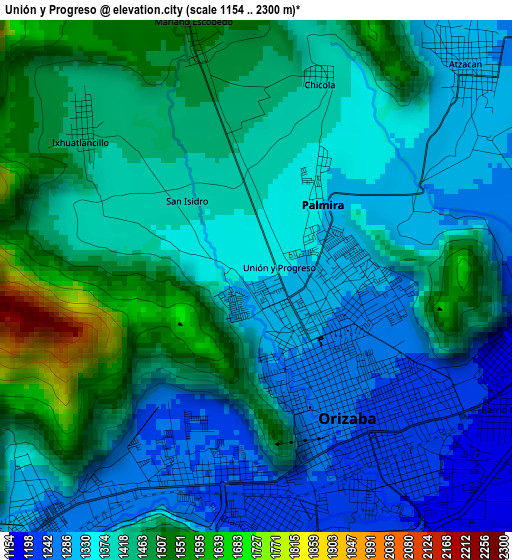
Below is the Elevation map of Unión y Progreso, which displays elevation range with different colors. Scale of the first map is from 1154 to 2300 m (3786 to 7546 ft) with average elevation of 1392.4 meters (=4568 ft) [note 1]
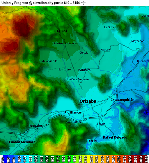
These maps also provides idea of topography and contour of this city, they are displayed at different zoom levels. More info about maps, scale and edge coordinates you can find below images.
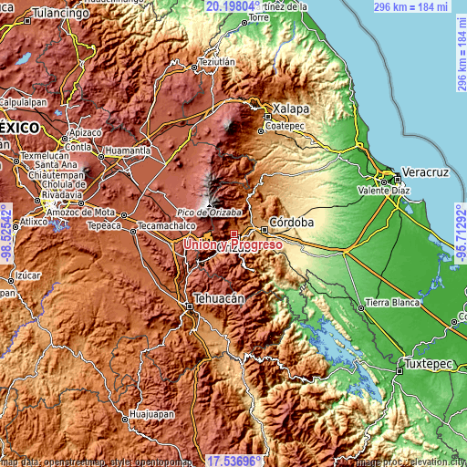
| \ | Map #1 | Map #2 | Topo.Map |
| Scale [m] | 1154..2300 m | 810..3154 m | × |
| Scale [ft] | 3786..7546 ft | 2657..10348 ft | × |
| Average | 1392.4 m = 4568 ft | 1571.6 m = 5156 ft | × |
| Width | 9.25 km = 5.7 mi | 18.49 km = 11.5 mi | 295.9 km = 183.9 mi |
| Height | 9.25 km = 5.7 mi | 18.49 km = 11.5 mi | 295.9 km = 183.9 mi |
| ↑Max Latitude | 18.914358° | 18.955925° | 20.19804° |
| Latitude at center | 18.87278° | 18.87278° | 18.87278° |
| ↓Min Latitude | 18.831192° | 18.789594° | 17.53696° |
| ← Min Longitude | -97.163115° | -97.207061° | -98.52542° |
| Longitude center | -97.11917° | -97.11917° | -97.11917° |
| →Max Longitude | -97.075225° | -97.031279° | -95.71292° |
Nearby cities:
Cities around Unión y Progreso sort by population:
• Orizaba elevation 1238 m
3.1 km,  138°
138°
• Río Blanco 1278 m
6.1 km,  219°
219°
• Palmira 1343 m
1.4 km,  36°
36°
• Atzacan 1299 m
5.4 km, 44°
• Jalapilla 1188 m
6.1 km,  148°
148°
• Ixhuatlancillo 1439 m
4.2 km,  311°
311°
• La Perla 1624 m
6.3 km,  346°
346°
• Fraccionamiento Valle Dorado 1325 m
0.5 km, 216°
• Mariano Escobedo 1533 m
4.7 km, 345°
• Chicola 1395 m
3.4 km,  20°
20°
• San Isidro 1417 m
2.2 km,  341°
341°
• San Cristóbal 1237 m
4.8 km,  185°
185°
Multilingual:
 En español:
Unión y Progreso elevación 1334 m.
 En France:
Unión y Progreso élévation 1334 m.
 Auf Deutsch:
Unión y Progreso höhe über dem Meeresspiegel ist 1334 m.

Sources and notes:
- [note 1] Map square and city borders are not equal. Map elevation data is calculated only from area inside that square.
- [src 1] Elevation data from geonames database provided with same terms of usage.
- [src 2] The elevation map of Unión y Progreso is generated using elevation data from NASA's 3 arcsec (90m) resolution SRTM data.
- [src 3] Base (background) map © OpenStreetMap contributors tiles are generated by Geofabrik and OpenTopoMap.
Copyright & License:
This Unión y Progreso Elevation Map is licensed under CC BY-SA. You may reuse any part from this page, if you give a proper credit by linking to this URL:
 More info on terms of use page.