La Perla elevation
La Perla (Veracruz), Mexico elevation is 1624 meters and La Perla elevation in feet is 5328 ft above sea level [src 1]. La Perla is a seat of a second-order administrative division (feature code) with elevation that is 310 meters (1017 ft) bigger than average city elevation in Mexico.
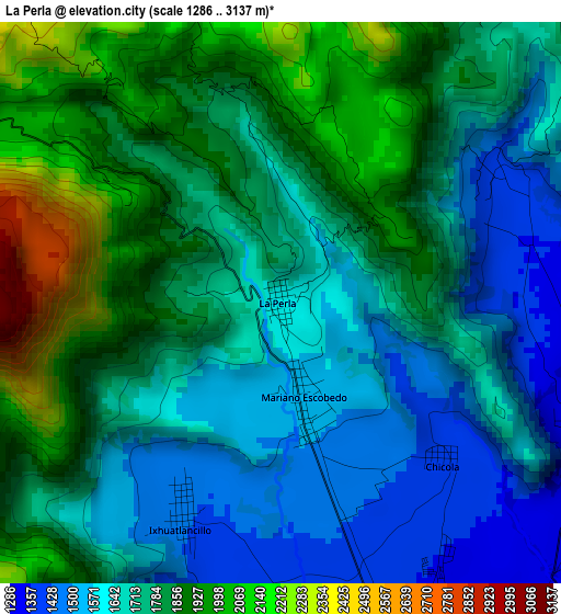
Below is the Elevation map of La Perla, which displays elevation range with different colors. Scale of the first map is from 1286 to 3137 m (4219 to 10292 ft) with average elevation of 1750.1 meters (=5742 ft) [note 1]
These maps also provides idea of topography and contour of this city, they are displayed at different zoom levels. More info about maps, scale and edge coordinates you can find below images.
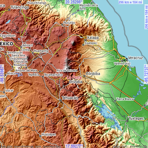
| \ | Map #1 | Map #2 | Topo.Map |
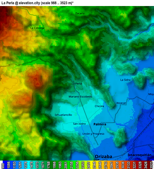
| Scale [m] | 1286..3137 m | 988..3523 m | × |
| Scale [ft] | 4219..10292 ft | 3241..11558 ft | × |
| Average | 1750.1 m = 5742 ft | 1876.8 m = 6157 ft | × |
| Width | 9.24 km = 5.7 mi | 18.49 km = 11.5 mi | 295.8 km = 183.8 mi |
| Height | 9.24 km = 5.7 mi | 18.49 km = 11.5 mi | 295.8 km = 183.8 mi |
| ↑Max Latitude | 18.969734° | 19.011287° | 20.25298° |
| Latitude at center | 18.92817° | 18.92817° | 18.92817° |
| ↓Min Latitude | 18.886596° | 18.845011° | 17.59277° |
| ← Min Longitude | -97.177565° | -97.221511° | -98.53987° |
| Longitude center | -97.13362° | -97.13362° | -97.13362° |
| →Max Longitude | -97.089675° | -97.045729° | -95.72737° |
Nearby cities:
Cities around La Perla sort by population:
• Palmira elevation 1343 m
5.6 km,  155°
155°
• Atzacan 1299 m
5.8 km,  113°
113°
• Unión y Progreso 1334 m
6.3 km,  166°
166°
• Ixhuatlancillo 1439 m
3.8 km,  205°
205°
• Fraccionamiento Valle Dorado 1325 m
6.7 km, 169°
• Mariano Escobedo 1533 m
1.7 km, 167°
• Chicola 1395 m
4 km,  137°
137°
• San Isidro 1417 m
4.2 km, 168°
• La Sidra 1342 m
5.7 km,  83°
83°
• Chilapa 2245 m
7.1 km,  342°
342°
• Barrio de San Miguel 1577 m
1 km,  68°
68°
• Metlac Hernández (Metlac Primero) 1898 m
5.6 km,  349°
349°
Multilingual:
 En español:
La Perla elevación 1624 m.
 En France:
La Perla élévation 1624 m.
 Auf Deutsch:
La Perla höhe über dem Meeresspiegel ist 1624 m.

Sources and notes:
- [note 1] Map square and city borders are not equal. Map elevation data is calculated only from area inside that square.
- [src 1] Elevation data from geonames database provided with same terms of usage.
- [src 2] The elevation map of La Perla is generated using elevation data from NASA's 3 arcsec (90m) resolution SRTM data.
- [src 3] Base (background) map © OpenStreetMap contributors tiles are generated by Geofabrik and OpenTopoMap.
Copyright & License:
This La Perla Elevation Map is licensed under CC BY-SA. You may reuse any part from this page, if you give a proper credit by linking to this URL:
 More info on terms of use page.