Guadalupe elevation
Guadalupe (Chiapas, Huehuetán), Mexico elevation is 172 meters and Guadalupe elevation in feet is 564 ft above sea level [src 1]. Guadalupe is a populated place (feature code) with elevation that is 1142 meters (3747 ft) smaller than average city elevation in Mexico.
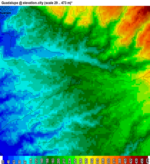
Below is the Elevation map of Guadalupe, which displays elevation range with different colors. Scale of the first map is from 29 to 473 m (95 to 1552 ft) with average elevation of 170.2 meters (=558 ft) [note 1]
These maps also provides idea of topography and contour of this city, they are displayed at different zoom levels. More info about maps, scale and edge coordinates you can find below images.
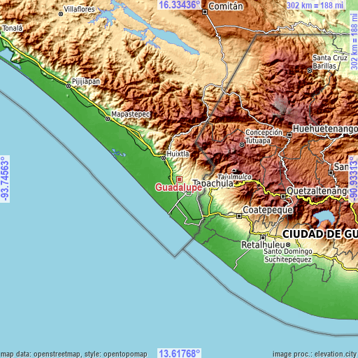
| \ | Map #1 | Topo.Map |
| Scale [m] | 29..473 m | × |
| Scale [ft] | 95..1552 ft | × |
| Average | 170.2 m = 558 ft | × |
| Width | 9.44 km = 5.9 mi | 302.1 km = 187.7 mi |
| Height | 9.44 km = 5.9 mi | 302.1 km = 187.7 mi |
| ↑Max Latitude | 15.022778° | 16.33436° |
| Latitude at center | 14.98033° | 14.98033° |
| ↓Min Latitude | 14.937874° | 13.61768° |
| ← Min Longitude | -92.383325° | -93.74563° |
| Longitude center | -92.33938° | -92.33938° |
| →Max Longitude | -92.295435° | -90.93313° |
Nearby cities:
Cities around Guadalupe sort by population:
• Tapachula elevation 170 m
12.2 km,  134°
134°
• Huehuetán 64 m
6.4 km,  313°
313°
• Vida Mejor I 89 m
12.8 km,  164°
164°
• Estación Huehuetán 30 m
8 km,  295°
295°
• Álvaro Obregón 47 m
7.7 km,  212°
212°
• Veinte de Noviembre 397 m
8 km,  92°
92°
• Los Cafetales 94 m
13.2 km, 162°
• Raymundo Enríquez 85 m
12.9 km,  168°
168°
• Viva México 88 m
7.9 km, 169°
• Nuevo Pumpuapa (Cereso) 45 m
6.7 km,  204°
204°
• Chamulapita 111 m
10.4 km,  341°
341°
• Marte R. Gómez 20 m
12.7 km,  241°
241°
Multilingual:
 En español:
Guadalupe elevación 172 m.
 En France:
Guadalupe élévation 172 m.
 Auf Deutsch:
Guadalupe höhe über dem Meeresspiegel ist 172 m.

Sources and notes:
- [note 1] Map square and city borders are not equal. Map elevation data is calculated only from area inside that square.
- [src 1] Elevation data from geonames database provided with same terms of usage.
- [src 2] The elevation map of Guadalupe is generated using elevation data from NASA's 3 arcsec (90m) resolution SRTM data.
- [src 3] Base (background) map © OpenStreetMap contributors tiles are generated by Geofabrik and OpenTopoMap.
Copyright & License:
This Guadalupe Elevation Map is licensed under CC BY-SA. You may reuse any part from this page, if you give a proper credit by linking to this URL:
 More info on terms of use page.