Tapachula elevation
Tapachula (Chiapas), Mexico elevation is 170 meters and Tapachula elevation in feet is 558 ft above sea level [src 1]. Tapachula is a seat of a second-order administrative division (feature code) with elevation that is 1144 meters (3753 ft) smaller than average city elevation in Mexico.
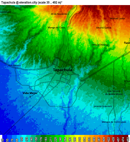
Below is the Elevation map of Tapachula, which displays elevation range with different colors. Scale of the first map is from 82 to 302 m (269 to 991 ft) with average elevation of 170.1 meters (=558 ft) [note 1]
These maps also provides idea of topography and contour of this city, they are displayed at different zoom levels. More info about maps, scale and edge coordinates you can find below images.

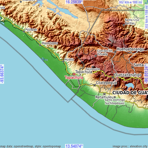
| \ | Map #1 | Map #2 | Topo.Map |
| Scale [m] | 82..302 m | 35..492 m | × |
| Scale [ft] | 269..991 ft | 115..1614 ft | × |
| Average | 170.1 m = 558 ft | 183.5 m = 602 ft | × |
| Width | 9.44 km = 5.9 mi | 18.89 km = 11.7 mi | 302.2 km = 187.8 mi |
| Height | 9.44 km = 5.9 mi | 18.89 km = 11.7 mi | 302.2 km = 187.8 mi |
| ↑Max Latitude | 14.946313° | 14.988767° | 16.25839° |
| Latitude at center | 14.90385° | 14.90385° | 14.90385° |
| ↓Min Latitude | 14.861379° | 14.818899° | 13.54074° |
| ← Min Longitude | -92.301435° | -92.345381° | -93.66374° |
| Longitude center | -92.25749° | -92.25749° | -92.25749° |
| →Max Longitude | -92.213545° | -92.169599° | -90.85124° |
Nearby cities:
Cities around Tapachula sort by population:
• Vida Mejor I elevation 89 m
6.6 km,  234°
234°
• Veinte de Noviembre 397 m
8.2 km,  354°
354°
• 2da. Sección de Medio Monte 187 m
8.2 km,  107°
107°
• Los Cafetales 94 m
6.3 km, 229°
• Raymundo Enríquez 85 m
7.4 km,  236°
236°
• Viva México 88 m
7.4 km,  275°
275°
• Llano de la Lima 99 m
6 km, 225°
• El Sacrificio 144 m
4.7 km,  137°
137°
• Cebadilla 1ra. Sección 114 m
5.1 km,  208°
208°
• Los Palacios 89 m
5.2 km,  180°
180°
• Omoa 86 m
8.3 km,  161°
161°
• Octavio Paz 104 m
5.2 km,  187°
187°
Multilingual:
 En español:
Tapachula, Tapachula de Córdova y Ordóñez elevación 170 m.
 En France:
Tapachula élévation 170 m.
 Auf Deutsch:
Tapachula höhe über dem Meeresspiegel ist 170 m.
 На русском:
Тапачуле, Тапачула высота над уровнем моря 170 м
Sources and notes:
- [note 1] Map square and city borders are not equal. Map elevation data is calculated only from area inside that square.
- [src 1] Elevation data from geonames database provided with same terms of usage.
- [src 2] The elevation map of Tapachula is generated using elevation data from NASA's 3 arcsec (90m) resolution SRTM data.
- [src 3] Base (background) map © OpenStreetMap contributors tiles are generated by Geofabrik and OpenTopoMap.
Copyright & License:
This Tapachula Elevation Map is licensed under CC BY-SA. You may reuse any part from this page, if you give a proper credit by linking to this URL:
 More info on terms of use page.