Omoa elevation
Omoa (Chiapas, Tuxtla Chico), Mexico elevation is 86 meters and Omoa elevation in feet is 282 ft above sea level [src 1]. Omoa is a populated place (feature code) with elevation that is 1228 meters (4029 ft) smaller than average city elevation in Mexico.
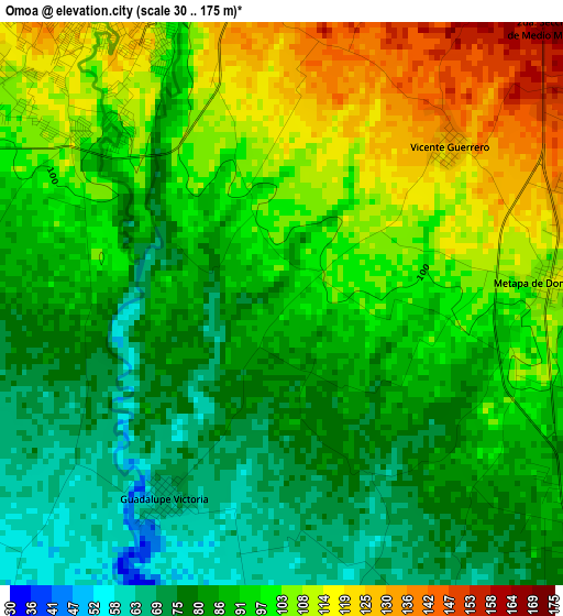
Below is the Elevation map of Omoa, which displays elevation range with different colors. Scale of the first map is from 30 to 175 m (98 to 574 ft) with average elevation of 93.2 meters (=306 ft) [note 1]
These maps also provides idea of topography and contour of this city, they are displayed at different zoom levels. More info about maps, scale and edge coordinates you can find below images.
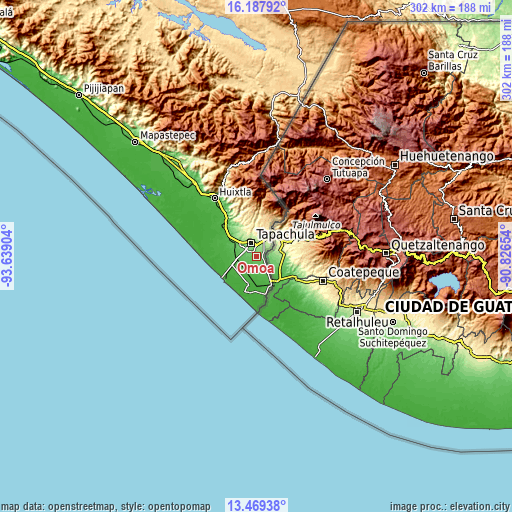
| \ | Map #1 | Topo.Map |
| Scale [m] | 30..175 m | × |
| Scale [ft] | 98..574 ft | × |
| Average | 93.2 m = 306 ft | × |
| Width | 9.45 km = 5.9 mi | 302.3 km = 187.8 mi |
| Height | 9.45 km = 5.9 mi | 302.3 km = 187.8 mi |
| ↑Max Latitude | 14.875397° | 16.18792° |
| Latitude at center | 14.83292° | 14.83292° |
| ↓Min Latitude | 14.790435° | 13.46938° |
| ← Min Longitude | -92.276735° | -93.63904° |
| Longitude center | -92.23279° | -92.23279° |
| →Max Longitude | -92.188845° | -90.82654° |
Nearby cities:
Cities around Omoa sort by population:
• Tapachula elevation 170 m
8.3 km,  341°
341°
• 2da. Sección de Medio Monte 187 m
7.5 km,  43°
43°
• Frontera Hidalgo 72 m
8.6 km,  136°
136°
• Los Cafetales 94 m
8.4 km,  297°
297°
• Metapa 112 m
4.4 km,  85°
85°
• Texcaltic 86 m
6.4 km,  130°
130°
• Llano de la Lima 99 m
7.8 km, 297°
• El Sacrificio 144 m
4.5 km,  6°
6°
• Cebadilla 1ra. Sección 114 m
6.1 km, 304°
• Guadalupe Victoria 68 m
3.8 km,  211°
211°
• Los Palacios 89 m
3.8 km,  314°
314°
• Octavio Paz 104 m
4.3 km, 309°
Multilingual:
 En español:
Omoa elevación 86 m.
 En France:
Omoa élévation 86 m.


Sources and notes:
- [note 1] Map square and city borders are not equal. Map elevation data is calculated only from area inside that square.
- [src 1] Elevation data from geonames database provided with same terms of usage.
- [src 2] The elevation map of Omoa is generated using elevation data from NASA's 3 arcsec (90m) resolution SRTM data.
- [src 3] Base (background) map © OpenStreetMap contributors tiles are generated by Geofabrik and OpenTopoMap.
Copyright & License:
This Omoa Elevation Map is licensed under CC BY-SA. You may reuse any part from this page, if you give a proper credit by linking to this URL:
 More info on terms of use page.