Hidalgo elevation
Hidalgo (Coahuila), Mexico elevation is 156 meters and Hidalgo elevation in feet is 512 ft above sea level [src 1]. Hidalgo is a seat of a second-order administrative division (feature code) with elevation that is 1158 meters (3799 ft) smaller than average city elevation in Mexico.
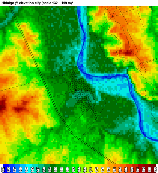
Below is the Elevation map of Hidalgo, which displays elevation range with different colors. Scale of the first map is from 132 to 199 m (433 to 653 ft) with average elevation of 161.9 meters (=531 ft) [note 1]
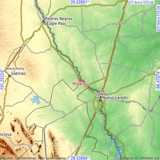
These maps also provides idea of topography and contour of this city, they are displayed at different zoom levels. More info about maps, scale and edge coordinates you can find below images.
| \ | Map #1 | Topo.Map |
| Scale [m] | 132..199 m | × |
| Scale [ft] | 433..653 ft | × |
| Average | 161.9 m = 531 ft | × |
| Width | 8.65 km = 5.4 mi | 276.6 km = 171.9 mi |
| Height | 8.65 km = 5.4 mi | 276.6 km = 171.9 mi |
| ↑Max Latitude | 27.82881° | 29.02681° |
| Latitude at center | 27.78994° | 27.78994° |
| ↓Min Latitude | 27.751056° | 26.53884° |
| ← Min Longitude | -99.920935° | -101.28324° |
| Longitude center | -99.87699° | -99.87699° |
| →Max Longitude | -99.833045° | -98.47074° |
Nearby cities:
Cities around Hidalgo sort by population:
• Nuevo Laredo elevation 130 m
49.8 km,  134°
134°
• Nava 329 m
111.9 km,  308°
308°
• Allende 385 m
113.5 km,  302°
302°
• Anáhuac 197 m
65.7 km,  202°
202°
• El Campanario y Oradel 144 m
43.4 km,  144°
144°
• Villa Unión 385 m
96.2 km, 299°
• Villa Union 381 m
95.1 km, 299°
• Lampazos de Naranjo 326 m
105.2 km,  216°
216°
• Colonia Venustiano Carranza 258 m
115.5 km,  324°
324°
• Guerrero 222 m
76.1 km, 319°
• Juárez 278 m
86.1 km,  256°
256°
• Progreso 309 m
116.7 km,  249°
249°
Multilingual:
 En español:
Hidalgo elevación 156 m.
 En France:
Hidalgo élévation 156 m.


Sources and notes:
- [note 1] Map square and city borders are not equal. Map elevation data is calculated only from area inside that square.
- [src 1] Elevation data from geonames database provided with same terms of usage.
- [src 2] The elevation map of Hidalgo is generated using elevation data from NASA's 3 arcsec (90m) resolution SRTM data.
- [src 3] Base (background) map © OpenStreetMap contributors tiles are generated by Geofabrik and OpenTopoMap.
Copyright & License:
This Hidalgo Elevation Map is licensed under CC BY-SA. You may reuse any part from this page, if you give a proper credit by linking to this URL:
 More info on terms of use page.