Huasca de Ocampo elevation
Huasca de Ocampo (Hidalgo), Mexico elevation is 2110 meters and Huasca de Ocampo elevation in feet is 6923 ft above sea level [src 1]. Huasca de Ocampo is a seat of a second-order administrative division (feature code) with elevation that is 796 meters (2612 ft) bigger than average city elevation in Mexico.
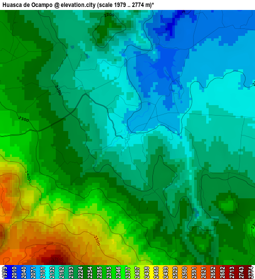
Below is the Elevation map of Huasca de Ocampo, which displays elevation range with different colors. Scale of the first map is from 1979 to 2774 m (6493 to 9101 ft) with average elevation of 2229.8 meters (=7316 ft) [note 1]
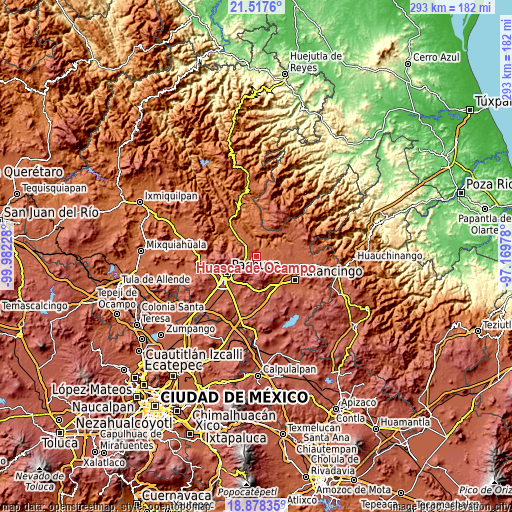
These maps also provides idea of topography and contour of this city, they are displayed at different zoom levels. More info about maps, scale and edge coordinates you can find below images.
| \ | Map #1 | Topo.Map |
| Scale [m] | 1979..2774 m | × |
| Scale [ft] | 6493..9101 ft | × |
| Average | 2229.8 m = 7316 ft | × |
| Width | 9.17 km = 5.7 mi | 293.5 km = 182.4 mi |
| Height | 9.17 km = 5.7 mi | 293.5 km = 182.4 mi |
| ↑Max Latitude | 20.244806° | 21.5176° |
| Latitude at center | 20.20357° | 20.20357° |
| ↓Min Latitude | 20.162323° | 18.87835° |
| ← Min Longitude | -98.619975° | -99.98228° |
| Longitude center | -98.57603° | -98.57603° |
| →Max Longitude | -98.532085° | -97.16978° |
Nearby cities:
Cities around Huasca de Ocampo sort by population:
• Mineral del Monte elevation 2732 m
12.5 km,  234°
234°
• Atotonilco el Grande 2099 m
13.3 km,  313°
313°
• La Estancia 2030 m
15.9 km, 311°
• San Antonio el Paso 2614 m
7.5 km,  213°
213°
• Los Sabinos 1985 m
14.6 km,  328°
328°
• Almoloya 2186 m
14.5 km,  113°
113°
• Carboneras 2583 m
12.4 km,  275°
275°
• Río Seco Puente de Doria 2099 m
7.9 km,  84°
84°
• Tlaxocoyucan 2095 m
9.4 km,  72°
72°
• Omitlán de Juárez 2420 m
8.4 km,  243°
243°
• San José Ocotillos 2315 m
3.9 km, 275°
• Acatlán 2148 m
15.6 km, 114°
Multilingual:
 En español:
Huasca de Ocampo elevación 2110 m.
 En France:
Huasca de Ocampo élévation 2110 m.
 Auf Deutsch:
Huasca de Ocampo höhe über dem Meeresspiegel ist 2110 m.

Sources and notes:
- [note 1] Map square and city borders are not equal. Map elevation data is calculated only from area inside that square.
- [src 1] Elevation data from geonames database provided with same terms of usage.
- [src 2] The elevation map of Huasca de Ocampo is generated using elevation data from NASA's 3 arcsec (90m) resolution SRTM data.
- [src 3] Base (background) map © OpenStreetMap contributors tiles are generated by Geofabrik and OpenTopoMap.
Copyright & License:
This Huasca de Ocampo Elevation Map is licensed under CC BY-SA. You may reuse any part from this page, if you give a proper credit by linking to this URL:
 More info on terms of use page.