La Estancia elevation
La Estancia (Hidalgo, Atotonilco el Grande), Mexico elevation is 2030 meters and La Estancia elevation in feet is 6660 ft above sea level [src 1]. La Estancia is a populated place (feature code) with elevation that is 716 meters (2349 ft) bigger than average city elevation in Mexico.
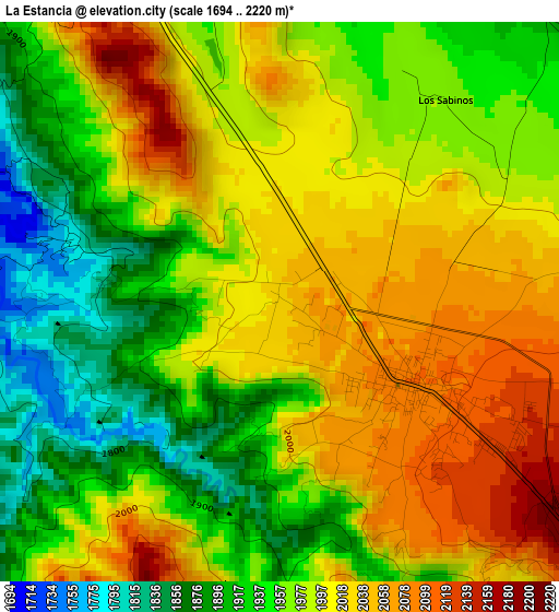
Below is the Elevation map of La Estancia, which displays elevation range with different colors. Scale of the first map is from 1694 to 2220 m (5558 to 7283 ft) with average elevation of 1981.2 meters (=6500 ft) [note 1]
These maps also provides idea of topography and contour of this city, they are displayed at different zoom levels. More info about maps, scale and edge coordinates you can find below images.
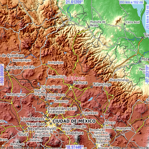
| \ | Map #1 | Topo.Map |
| Scale [m] | 1694..2220 m | × |
| Scale [ft] | 5558..7283 ft | × |
| Average | 1981.2 m = 6500 ft | × |
| Width | 9.17 km = 5.7 mi | 293.3 km = 182.2 mi |
| Height | 9.17 km = 5.7 mi | 293.3 km = 182.2 mi |
| ↑Max Latitude | 20.340101° | 21.61209° |
| Latitude at center | 20.29889° | 20.29889° |
| ↓Min Latitude | 20.257668° | 18.97446° |
| ← Min Longitude | -98.733385° | -100.09569° |
| Longitude center | -98.68944° | -98.68944° |
| →Max Longitude | -98.645495° | -97.28319° |
Nearby cities:
Cities around La Estancia sort by population:
• Mineral del Monte elevation 2732 m
17.9 km,  174°
174°
• Atotonilco el Grande 2099 m
2.6 km,  122°
122°
• San Miguel Cerezo (El Cerezo) 2677 m
16.1 km,  194°
194°
• La Estanzuela 2769 m
15.2 km,  207°
207°
• Santa María Amajac 1705 m
6.3 km,  296°
296°
• Los Sabinos 1985 m
4.6 km,  66°
66°
• Tiltepec 2019 m
1.8 km,  22°
22°
• Carboneras 2583 m
9.5 km,  183°
183°
• Camelia (Barrio la Camelia) 2580 m
17 km, 191°
• Omitlán de Juárez 2420 m
15 km,  163°
163°
• San José Ocotillos 2315 m
13 km,  142°
142°
• Huasca de Ocampo 2110 m
15.9 km,  131°
131°
Multilingual:
 En español:
La Estancia elevación 2030 m.
 En France:
La Estancia élévation 2030 m.
 Auf Deutsch:
La Estancia höhe über dem Meeresspiegel ist 2030 m.

Sources and notes:
- [note 1] Map square and city borders are not equal. Map elevation data is calculated only from area inside that square.
- [src 1] Elevation data from geonames database provided with same terms of usage.
- [src 2] The elevation map of La Estancia is generated using elevation data from NASA's 3 arcsec (90m) resolution SRTM data.
- [src 3] Base (background) map © OpenStreetMap contributors tiles are generated by Geofabrik and OpenTopoMap.
Copyright & License:
This La Estancia Elevation Map is licensed under CC BY-SA. You may reuse any part from this page, if you give a proper credit by linking to this URL:
 More info on terms of use page.