Omitlán de Juárez elevation
Omitlán de Juárez (Hidalgo), Mexico elevation is 2420 meters and Omitlán de Juárez elevation in feet is 7940 ft above sea level [src 1]. Omitlán de Juárez is a seat of a second-order administrative division (feature code) with elevation that is 1106 meters (3629 ft) bigger than average city elevation in Mexico.
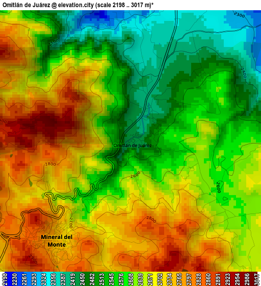
Below is the Elevation map of Omitlán de Juárez, which displays elevation range with different colors. Scale of the first map is from 2198 to 3017 m (7211 to 9898 ft) with average elevation of 2632.9 meters (=8638 ft) [note 1]
These maps also provides idea of topography and contour of this city, they are displayed at different zoom levels. More info about maps, scale and edge coordinates you can find below images.
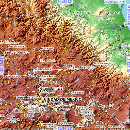
| \ | Map #1 | Topo.Map |
| Scale [m] | 2198..3017 m | × |
| Scale [ft] | 7211..9898 ft | × |
| Average | 2632.9 m = 8638 ft | × |
| Width | 9.17 km = 5.7 mi | 293.5 km = 182.4 mi |
| Height | 9.17 km = 5.7 mi | 293.5 km = 182.4 mi |
| ↑Max Latitude | 20.211045° | 21.48413° |
| Latitude at center | 20.1698° | 20.1698° |
| ↓Min Latitude | 20.128544° | 18.84431° |
| ← Min Longitude | -98.692365° | -100.05467° |
| Longitude center | -98.64842° | -98.64842° |
| →Max Longitude | -98.604475° | -97.24217° |
Nearby cities:
Cities around Omitlán de Juárez sort by population:
• Mineral del Monte elevation 2732 m
4.4 km,  216°
216°
• Manuel Ávila Camacho 2499 m
8.9 km, 223°
• San Miguel Cerezo (El Cerezo) 2677 m
8.4 km,  261°
261°
• Guadalupe Minerva 2492 m
8.4 km,  234°
234°
• Santiago Jaltepec 2441 m
9.4 km, 224°
• Colonia Militar 2510 m
8.6 km, 221°
• Rio de la Soledad 2458 m
9 km, 227°
• San Antonio el Paso 2614 m
4.2 km,  126°
126°
• Carboneras 2583 m
6.9 km,  315°
315°
• Camelia (Barrio la Camelia) 2580 m
8 km,  253°
253°
• San José Ocotillos 2315 m
5.5 km,  41°
41°
• Huasca de Ocampo 2110 m
8.4 km,  63°
63°
Multilingual:
 En español:
Omitlán de Juárez elevación 2420 m.
 En France:
Omitlán de Juárez élévation 2420 m.
 Auf Deutsch:
Omitlán de Juárez höhe über dem Meeresspiegel ist 2420 m.
 На русском:
Omitlán de Juárez высота над уровнем моря 2420 м
Sources and notes:
- [note 1] Map square and city borders are not equal. Map elevation data is calculated only from area inside that square.
- [src 1] Elevation data from geonames database provided with same terms of usage.
- [src 2] The elevation map of Omitlán de Juárez is generated using elevation data from NASA's 3 arcsec (90m) resolution SRTM data.
- [src 3] Base (background) map © OpenStreetMap contributors tiles are generated by Geofabrik and OpenTopoMap.
Copyright & License:
This Omitlán de Juárez Elevation Map is licensed under CC BY-SA. You may reuse any part from this page, if you give a proper credit by linking to this URL:
 More info on terms of use page.