Río Seco Puente de Doria elevation
Río Seco Puente de Doria (Hidalgo, Huasca de Ocampo), Mexico elevation is 2099 meters and Río Seco Puente de Doria elevation in feet is 6886 ft above sea level [src 1]. Río Seco Puente de Doria is a populated place (feature code) with elevation that is 785 meters (2575 ft) bigger than average city elevation in Mexico.
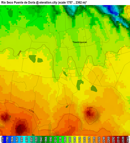
Below is the Elevation map of Río Seco Puente de Doria, which displays elevation range with different colors. Scale of the first map is from 1757 to 2362 m (5764 to 7749 ft) with average elevation of 2119.9 meters (=6955 ft) [note 1]
These maps also provides idea of topography and contour of this city, they are displayed at different zoom levels. More info about maps, scale and edge coordinates you can find below images.
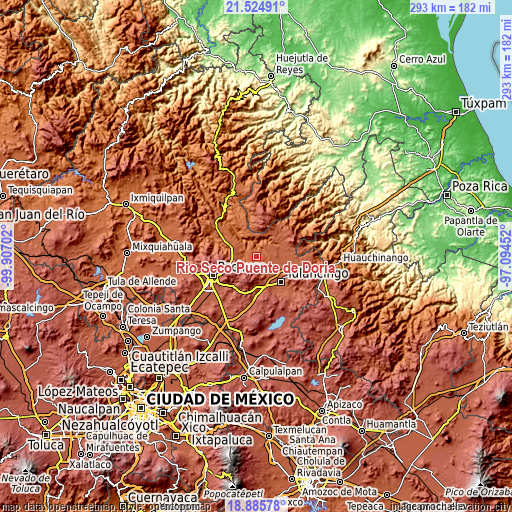
| \ | Map #1 | Topo.Map |
| Scale [m] | 1757..2362 m | × |
| Scale [ft] | 5764..7749 ft | × |
| Average | 2119.9 m = 6955 ft | × |
| Width | 9.17 km = 5.7 mi | 293.4 km = 182.3 mi |
| Height | 9.17 km = 5.7 mi | 293.5 km = 182.4 mi |
| ↑Max Latitude | 20.252174° | 21.52491° |
| Latitude at center | 20.21094° | 20.21094° |
| ↓Min Latitude | 20.169695° | 18.88578° |
| ← Min Longitude | -98.544715° | -99.90702° |
| Longitude center | -98.50077° | -98.50077° |
| →Max Longitude | -98.456825° | -97.09452° |
Nearby cities:
Cities around Río Seco Puente de Doria sort by population:
• Jaltepec elevation 2164 m
13.7 km,  140°
140°
• Rincones de la Hacienda 2148 m
14.5 km,  134°
134°
• Colonia 28 de Mayo (Santa Rosa) 2128 m
12.6 km,  113°
113°
• La Lagunilla 2473 m
16.1 km,  171°
171°
• San Antonio el Paso 2614 m
14 km,  239°
239°
• Almoloya 2186 m
8.6 km, 140°
• Metepec Primero 2152 m
10.5 km, 137°
• Tlaxocoyucan 2095 m
2.3 km,  28°
28°
• San José Ocotillos 2315 m
11.7 km,  267°
267°
• Fraccionamiento Carlos Salinas de Gortari 2179 m
13.4 km,  146°
146°
• Huasca de Ocampo 2110 m
7.9 km,  264°
264°
• Acatlán 2148 m
9.7 km, 138°
Multilingual:
 En español:
Río Seco Puente de Doria elevación 2099 m.
 En France:
Río Seco Puente de Doria élévation 2099 m.
 Auf Deutsch:
Río Seco Puente de Doria höhe über dem Meeresspiegel ist 2099 m.
 На русском:
Río Seco Puente de Doria высота над уровнем моря 2099 м
Sources and notes:
- [note 1] Map square and city borders are not equal. Map elevation data is calculated only from area inside that square.
- [src 1] Elevation data from geonames database provided with same terms of usage.
- [src 2] The elevation map of Río Seco Puente de Doria is generated using elevation data from NASA's 3 arcsec (90m) resolution SRTM data.
- [src 3] Base (background) map © OpenStreetMap contributors tiles are generated by Geofabrik and OpenTopoMap.
Copyright & License:
This Río Seco Puente de Doria Elevation Map is licensed under CC BY-SA. You may reuse any part from this page, if you give a proper credit by linking to this URL:
 More info on terms of use page.