Jalpan elevation
Jalpan (Querétaro, Jalpan de Serra), Mexico elevation is 744 meters and Jalpan elevation in feet is 2441 ft above sea level [src 1]. Jalpan is a seat of a second-order administrative division (feature code) with elevation that is 570 meters (1870 ft) smaller than average city elevation in Mexico.
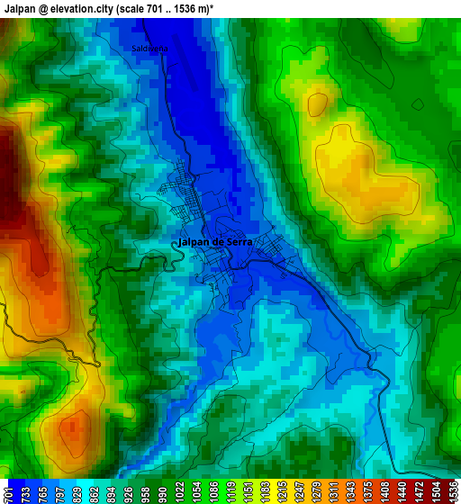
Below is the Elevation map of Jalpan, which displays elevation range with different colors. Scale of the first map is from 701 to 1536 m (2300 to 5039 ft) with average elevation of 981.1 meters (=3219 ft) [note 1]
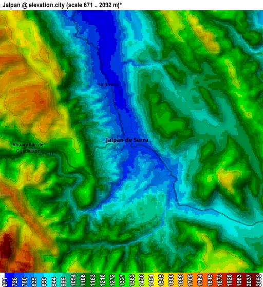
These maps also provides idea of topography and contour of this city, they are displayed at different zoom levels. More info about maps, scale and edge coordinates you can find below images.
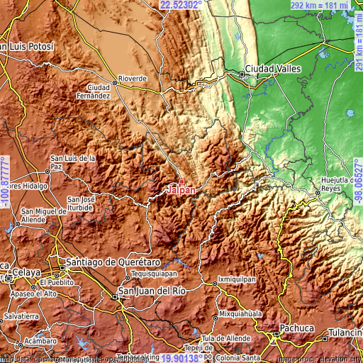
| \ | Map #1 | Map #2 | Topo.Map |
| Scale [m] | 701..1536 m | 671..2092 m | × |
| Scale [ft] | 2300..5039 ft | 2201..6864 ft | × |
| Average | 981.1 m = 3219 ft | 1169.7 m = 3838 ft | × |
| Width | 9.11 km = 5.7 mi | 18.22 km = 11.3 mi | 291.5 km = 181.1 mi |
| Height | 9.11 km = 5.7 mi | 18.22 km = 11.3 mi | 291.5 km = 181.1 mi |
| ↑Max Latitude | 21.258981° | 21.29993° | 22.52302° |
| Latitude at center | 21.21802° | 21.21802° | 21.21802° |
| ↓Min Latitude | 21.177048° | 21.136065° | 19.90138° |
| ← Min Longitude | -99.515465° | -99.559411° | -100.87777° |
| Longitude center | -99.47152° | -99.47152° | -99.47152° |
| →Max Longitude | -99.427575° | -99.383629° | -98.06527° |
Nearby cities:
Cities around Jalpan sort by population:
• Jacala elevation 1360 m
37.2 km,  128°
128°
• Purísima de Arista 717 m
11.2 km,  337°
337°
• Pinal de Amoles 2340 m
18.5 km,  239°
239°
• San Joaquín 2415 m
35 km,  196°
196°
• Ahuacatlán de Guadalupe 1115 m
7.2 km,  267°
267°
• Landa de Matamoros 1027 m
16.1 km,  103°
103°
• Agua Fría 1823 m
35.5 km,  258°
258°
• Agua Zarca 1364 m
39.5 km,  89°
89°
• Peñamiller 1343 m
40.1 km, 242°
• Concá 570 m
30.4 km,  325°
325°
• Lagunillas 933 m
42.5 km,  346°
346°
• Atarjea 1215 m
26.3 km,  282°
282°
Multilingual:
 En español:
Jalpan, Jalpan de Serra elevación 744 m.
 En France:
Jalpan élévation 744 m.


Sources and notes:
- [note 1] Map square and city borders are not equal. Map elevation data is calculated only from area inside that square.
- [src 1] Elevation data from geonames database provided with same terms of usage.
- [src 2] The elevation map of Jalpan is generated using elevation data from NASA's 3 arcsec (90m) resolution SRTM data.
- [src 3] Base (background) map © OpenStreetMap contributors tiles are generated by Geofabrik and OpenTopoMap.
Copyright & License:
This Jalpan Elevation Map is licensed under CC BY-SA. You may reuse any part from this page, if you give a proper credit by linking to this URL:
 More info on terms of use page.