Agua Zarca elevation
Agua Zarca (Querétaro, Landa de Matamoros), Mexico elevation is 1364 meters and Agua Zarca elevation in feet is 4475 ft above sea level [src 1]. Agua Zarca is a populated place (feature code) with elevation that is 50 meters (164 ft) bigger than average city elevation in Mexico.
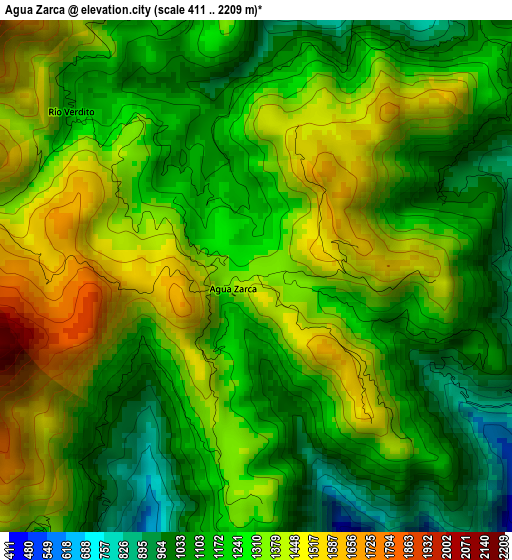
Below is the Elevation map of Agua Zarca, which displays elevation range with different colors. Scale of the first map is from 411 to 2209 m (1348 to 7247 ft) with average elevation of 1263.8 meters (=4146 ft) [note 1]
These maps also provides idea of topography and contour of this city, they are displayed at different zoom levels. More info about maps, scale and edge coordinates you can find below images.
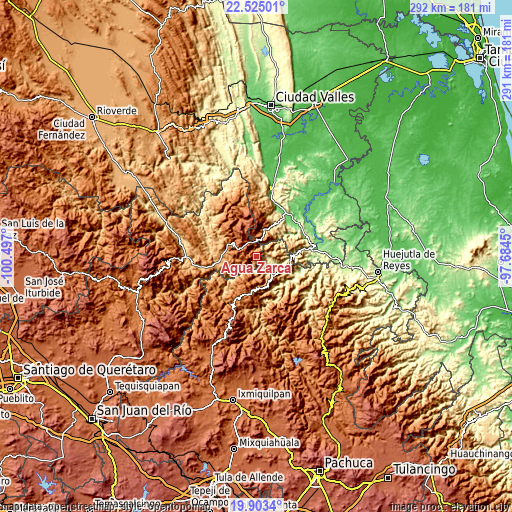
| \ | Map #1 | Topo.Map |
| Scale [m] | 411..2209 m | × |
| Scale [ft] | 1348..7247 ft | × |
| Average | 1263.8 m = 4146 ft | × |
| Width | 9.11 km = 5.7 mi | 291.5 km = 181.1 mi |
| Height | 9.11 km = 5.7 mi | 291.5 km = 181.1 mi |
| ↑Max Latitude | 21.26099° | 22.52501° |
| Latitude at center | 21.22003° | 21.22003° |
| ↓Min Latitude | 21.179059° | 19.9034° |
| ← Min Longitude | -99.134695° | -100.497° |
| Longitude center | -99.09075° | -99.09075° |
| →Max Longitude | -99.046805° | -97.6845° |
Nearby cities:
Cities around Agua Zarca sort by population:
• Xilitla elevation 654 m
21.3 km,  29°
29°
• Jacala 1360 m
25.6 km,  204°
204°
• Chapulhuacán 942 m
20.6 km,  109°
109°
• Pisaflores 267 m
9.3 km, 108°
• Landa de Matamoros 1027 m
24.1 km,  260°
260°
• Santa Ana de Allende 1344 m
15.3 km,  134°
134°
• Iztacapa 719 m
22.7 km,  42°
42°
• Zapuyo 495 m
23.1 km,  49°
49°
• Tamán 168 m
21.9 km,  86°
86°
• Santiago Centro 712 m
23.6 km, 93°
• Tlacuilola 171 m
23.2 km, 85°
• San Francisco 1012 m
21.8 km,  72°
72°
Multilingual:
 En español:
Agua Zarca elevación 1364 m.
 En France:
Agua Zarca élévation 1364 m.
 Auf Deutsch:
Agua Zarca höhe über dem Meeresspiegel ist 1364 m.

Sources and notes:
- [note 1] Map square and city borders are not equal. Map elevation data is calculated only from area inside that square.
- [src 1] Elevation data from geonames database provided with same terms of usage.
- [src 2] The elevation map of Agua Zarca is generated using elevation data from NASA's 3 arcsec (90m) resolution SRTM data.
- [src 3] Base (background) map © OpenStreetMap contributors tiles are generated by Geofabrik and OpenTopoMap.
Copyright & License:
This Agua Zarca Elevation Map is licensed under CC BY-SA. You may reuse any part from this page, if you give a proper credit by linking to this URL:
 More info on terms of use page.