Chapulhuacán elevation
Chapulhuacán (Hidalgo), Mexico elevation is 942 meters and Chapulhuacán elevation in feet is 3091 ft above sea level [src 1]. Chapulhuacán is a populated place (feature code) with elevation that is 372 meters (1220 ft) smaller than average city elevation in Mexico.
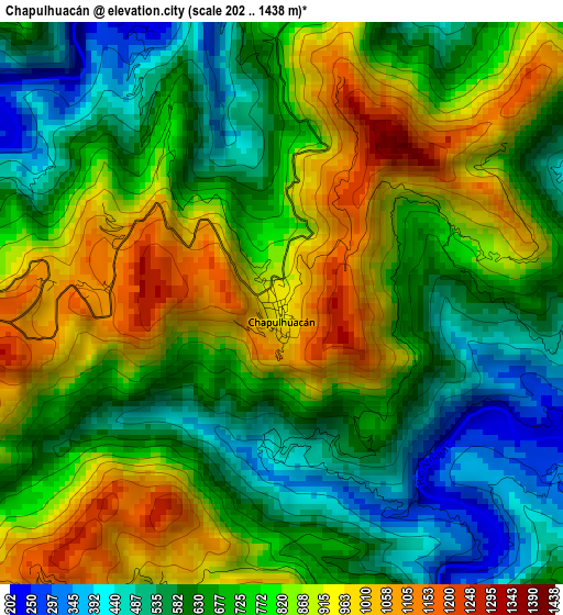
Below is the Elevation map of Chapulhuacán, which displays elevation range with different colors. Scale of the first map is from 202 to 1438 m (663 to 4718 ft) with average elevation of 743.3 meters (=2439 ft) [note 1]
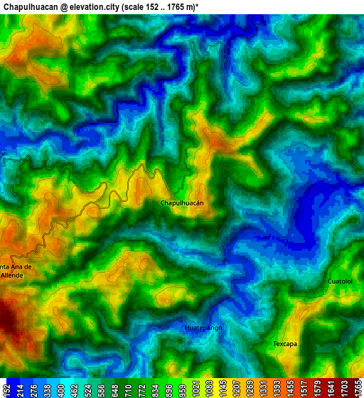
These maps also provides idea of topography and contour of this city, they are displayed at different zoom levels. More info about maps, scale and edge coordinates you can find below images.
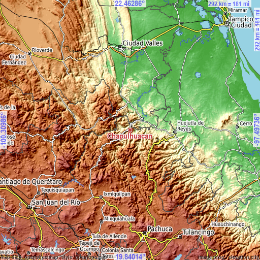
| \ | Map #1 | Map #2 | Topo.Map |
| Scale [m] | 202..1438 m | 152..1765 m | × |
| Scale [ft] | 663..4718 ft | 499..5791 ft | × |
| Average | 743.3 m = 2439 ft | 708.2 m = 2323 ft | × |
| Width | 9.11 km = 5.7 mi | 18.23 km = 11.3 mi | 291.6 km = 181.2 mi |
| Height | 9.11 km = 5.7 mi | 18.23 km = 11.3 mi | 291.6 km = 181.2 mi |
| ↑Max Latitude | 21.198287° | 21.239253° | 22.46286° |
| Latitude at center | 21.15731° | 21.15731° | 21.15731° |
| ↓Min Latitude | 21.116321° | 21.075321° | 19.84014° |
| ← Min Longitude | -98.947555° | -98.991501° | -100.30986° |
| Longitude center | -98.90361° | -98.90361° | -98.90361° |
| →Max Longitude | -98.859665° | -98.815719° | -97.49736° |
Nearby cities:
Cities around Chapulhuacán sort by population:
• Tezapotla elevation 508 m
9.6 km,  79°
79°
• Tlalnepantla 377 m
6.5 km,  67°
67°
• Pisaflores 267 m
11.3 km,  291°
291°
• Texcapa 1056 m
8.9 km,  144°
144°
• Cuatolol 860 m
9.1 km,  117°
117°
• Santa Ana de Allende 1344 m
9.4 km,  245°
245°
• Zacualtipanito 611 m
10.8 km,  91°
91°
• La Reforma 416 m
10 km,  159°
159°
• Tamán 168 m
8.7 km,  16°
16°
• Pemucho 794 m
8.8 km,  59°
59°
• Santiago Centro 712 m
6.8 km,  37°
37°
• Tlacuilola 171 m
9.6 km, 22°
Multilingual:
 En español:
Chapulhuacán elevación 942 m.
 En France:
Chapulhuacán élévation 942 m.
 Auf Deutsch:
Chapulhuacán höhe über dem Meeresspiegel ist 942 m.

Sources and notes:
- [note 1] Map square and city borders are not equal. Map elevation data is calculated only from area inside that square.
- [src 1] Elevation data from geonames database provided with same terms of usage.
- [src 2] The elevation map of Chapulhuacán is generated using elevation data from NASA's 3 arcsec (90m) resolution SRTM data.
- [src 3] Base (background) map © OpenStreetMap contributors tiles are generated by Geofabrik and OpenTopoMap.
Copyright & License:
This Chapulhuacán Elevation Map is licensed under CC BY-SA. You may reuse any part from this page, if you give a proper credit by linking to this URL:
 More info on terms of use page.