La Reforma elevation
La Reforma (Hidalgo, Tepehuacán de Guerrero), Mexico elevation is 416 meters and La Reforma elevation in feet is 1365 ft above sea level [src 1]. La Reforma is a populated place (feature code) with elevation that is 898 meters (2946 ft) smaller than average city elevation in Mexico.
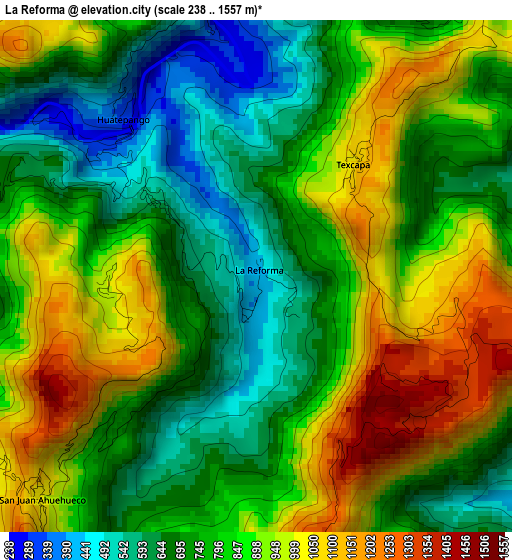
Below is the Elevation map of La Reforma, which displays elevation range with different colors. Scale of the first map is from 238 to 1557 m (781 to 5108 ft) with average elevation of 818.8 meters (=2686 ft) [note 1]
These maps also provides idea of topography and contour of this city, they are displayed at different zoom levels. More info about maps, scale and edge coordinates you can find below images.
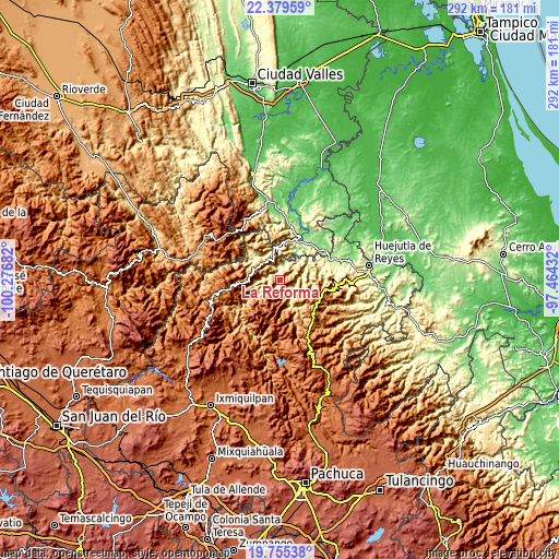
| \ | Map #1 | Topo.Map |
| Scale [m] | 238..1557 m | × |
| Scale [ft] | 781..5108 ft | × |
| Average | 818.8 m = 2686 ft | × |
| Width | 9.12 km = 5.7 mi | 291.8 km = 181.3 mi |
| Height | 9.12 km = 5.7 mi | 291.8 km = 181.3 mi |
| ↑Max Latitude | 21.114271° | 22.37959° |
| Latitude at center | 21.07327° | 21.07327° |
| ↓Min Latitude | 21.032258° | 19.75538° |
| ← Min Longitude | -98.914515° | -100.27682° |
| Longitude center | -98.87057° | -98.87057° |
| →Max Longitude | -98.826625° | -97.46432° |
Nearby cities:
Cities around La Reforma sort by population:
• Chapulhuacán elevation 942 m
10 km,  339°
339°
• Tezapotla 508 m
12.7 km,  28°
28°
• Tlalnepantla 377 m
12.1 km,  12°
12°
• Acoyotla 881 m
11.3 km,  59°
59°
• Texcapa 1056 m
2.7 km,  39°
39°
• Cuatolol 860 m
7 km, 42°
• Santa Ana de Allende 1344 m
13.2 km,  294°
294°
• San Juan Ahuehueco 1039 m
5.2 km,  227°
227°
• Zacualtipanito 611 m
11.6 km, 39°
• Pemucho 794 m
14.4 km,  16°
16°
• Tepehuacán de Guerrero 876 m
7.3 km,  155°
155°
• Cuazahuatl 1358 m
6.5 km,  195°
195°
Multilingual:
 En español:
La Reforma elevación 416 m.
 En France:
La Reforma élévation 416 m.
 Auf Deutsch:
La Reforma höhe über dem Meeresspiegel ist 416 m.

Sources and notes:
- [note 1] Map square and city borders are not equal. Map elevation data is calculated only from area inside that square.
- [src 1] Elevation data from geonames database provided with same terms of usage.
- [src 2] The elevation map of La Reforma is generated using elevation data from NASA's 3 arcsec (90m) resolution SRTM data.
- [src 3] Base (background) map © OpenStreetMap contributors tiles are generated by Geofabrik and OpenTopoMap.
Copyright & License:
This La Reforma Elevation Map is licensed under CC BY-SA. You may reuse any part from this page, if you give a proper credit by linking to this URL:
 More info on terms of use page.