Agua Fría elevation
Agua Fría (Querétaro, Peñamiller), Mexico elevation is 1823 meters and Agua Fría elevation in feet is 5981 ft above sea level [src 1]. Agua Fría is a populated place (feature code) with elevation that is 509 meters (1670 ft) bigger than average city elevation in Mexico.
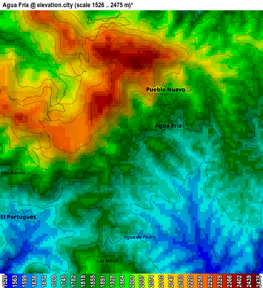
Below is the Elevation map of Agua Fría, which displays elevation range with different colors. Scale of the first map is from 1526 to 2475 m (5007 to 8120 ft) with average elevation of 1906.1 meters (=6254 ft) [note 1]
These maps also provides idea of topography and contour of this city, they are displayed at different zoom levels. More info about maps, scale and edge coordinates you can find below images.
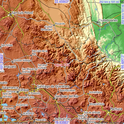
| \ | Map #1 | Topo.Map |
| Scale [m] | 1526..2475 m | × |
| Scale [ft] | 5007..8120 ft | × |
| Average | 1906.1 m = 6254 ft | × |
| Width | 9.11 km = 5.7 mi | 291.6 km = 181.2 mi |
| Height | 9.11 km = 5.7 mi | 291.6 km = 181.2 mi |
| ↑Max Latitude | 21.194019° | 22.45863° |
| Latitude at center | 21.15304° | 21.15304° |
| ↓Min Latitude | 21.11205° | 19.83583° |
| ← Min Longitude | -99.850325° | -101.21263° |
| Longitude center | -99.80638° | -99.80638° |
| →Max Longitude | -99.762435° | -98.40013° |
Nearby cities:
Cities around Agua Fría sort by population:
• Jalpan elevation 744 m
35.5 km,  78°
78°
• San Pablo Tolimán 1677 m
34.3 km,  196°
196°
• Tolimán 1566 m
30.1 km,  205°
205°
• Purísima de Arista 717 m
35.2 km,  60°
60°
• Pinal de Amoles 2340 m
18.8 km,  96°
96°
• San Joaquín 2415 m
36.4 km,  136°
136°
• Ahuacatlán de Guadalupe 1115 m
28.4 km, 76°
• Xichú 1317 m
30.7 km,  302°
302°
• Higuerillas 1568 m
26.7 km,  170°
170°
• Santa Catarina 1586 m
27.4 km,  267°
267°
• Peñamiller 1343 m
11 km,  185°
185°
• Atarjea 1215 m
15.6 km,  35°
35°
Multilingual:
 En español:
Agua Fría elevación 1823 m.
 En France:
Agua Fría élévation 1823 m.
 Auf Deutsch:
Agua Fría höhe über dem Meeresspiegel ist 1823 m.

Sources and notes:
- [note 1] Map square and city borders are not equal. Map elevation data is calculated only from area inside that square.
- [src 1] Elevation data from geonames database provided with same terms of usage.
- [src 2] The elevation map of Agua Fría is generated using elevation data from NASA's 3 arcsec (90m) resolution SRTM data.
- [src 3] Base (background) map © OpenStreetMap contributors tiles are generated by Geofabrik and OpenTopoMap.
Copyright & License:
This Agua Fría Elevation Map is licensed under CC BY-SA. You may reuse any part from this page, if you give a proper credit by linking to this URL:
 More info on terms of use page.