Oaxtepec elevation
Oaxtepec (Morelos, Yautepec), Mexico elevation is 1461 meters and Oaxtepec elevation in feet is 4793 ft above sea level [src 1]. Oaxtepec is a populated place (feature code) with elevation that is 147 meters (482 ft) bigger than average city elevation in Mexico.
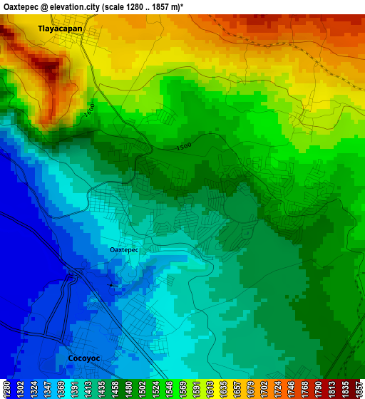
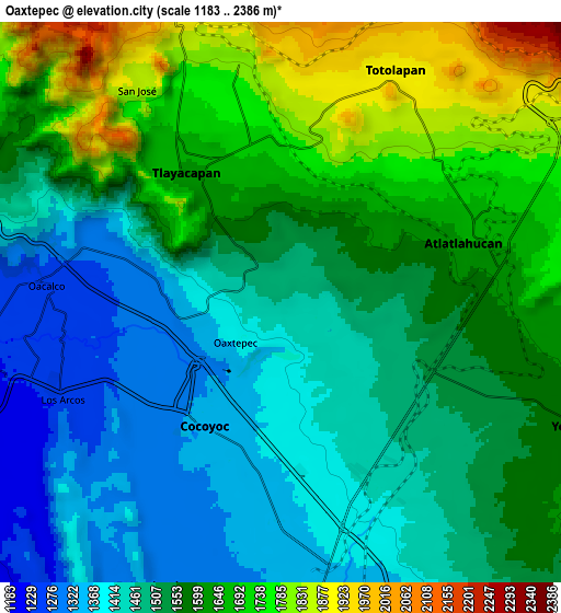
Below is the Elevation map of Oaxtepec, which displays elevation range with different colors. Scale of the first map is from 1280 to 1857 m (4199 to 6093 ft) with average elevation of 1485 meters (=4872 ft) [note 1]
These maps also provides idea of topography and contour of this city, they are displayed at different zoom levels. More info about maps, scale and edge coordinates you can find below images.
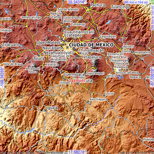
| \ | Map #1 | Map #2 | Topo.Map |
| Scale [m] | 1280..1857 m | 1183..2386 m | × |
| Scale [ft] | 4199..6093 ft | 3881..7828 ft | × |
| Average | 1485 m = 4872 ft | 1552.3 m = 5093 ft | × |
| Width | 9.24 km = 5.7 mi | 18.49 km = 11.5 mi | 295.8 km = 183.8 mi |
| Height | 9.24 km = 5.7 mi | 18.49 km = 11.5 mi | 295.8 km = 183.8 mi |
| ↑Max Latitude | 18.959816° | 19.001372° | 20.24314° |
| Latitude at center | 18.91825° | 18.91825° | 18.91825° |
| ↓Min Latitude | 18.876673° | 18.835086° | 17.58278° |
| ← Min Longitude | -99.000385° | -99.044331° | -100.36269° |
| Longitude center | -98.95644° | -98.95644° | -98.95644° |
| →Max Longitude | -98.912495° | -98.868549° | -97.55019° |
Nearby cities:
Cities around Oaxtepec sort by population:
• Cocoyoc elevation 1327 m
4.6 km,  215°
215°
• Tlayacapan 1637 m
4.9 km,  327°
327°
• Atlatlahucan 1637 m
6.4 km,  73°
73°
• Peña Flores (Palo Verde) 1352 m
5.8 km,  192°
192°
• Narciso Mendoza 1352 m
5.1 km,  195°
195°
• Cuauhtempan (San Andrés Cuauhtempan) 1860 m
6.4 km,  9°
9°
• Ignacio Bastida (Santa Catarina Tlayca) 1302 m
6.6 km,  291°
291°
• San Juan Texcalpan 1603 m
3.5 km,  55°
55°
• Emiliano Zapata (Casahuates) 1518 m
1.4 km,  349°
349°
• Yecapixteca 1501 m
6.9 km,  125°
125°
• Tierra Larga (Campo Nuevo) 1382 m
6 km,  171°
171°
• Colonia San Francisco 1523 m
6.1 km,  113°
113°
Multilingual:
 En español:
Oaxtepec elevación 1461 m.
 En France:
Oaxtepec élévation 1461 m.
 Auf Deutsch:
Oaxtepec höhe über dem Meeresspiegel ist 1461 m.

Sources and notes:
- [note 1] Map square and city borders are not equal. Map elevation data is calculated only from area inside that square.
- [src 1] Elevation data from geonames database provided with same terms of usage.
- [src 2] The elevation map of Oaxtepec is generated using elevation data from NASA's 3 arcsec (90m) resolution SRTM data.
- [src 3] Base (background) map © OpenStreetMap contributors tiles are generated by Geofabrik and OpenTopoMap.
Copyright & License:
This Oaxtepec Elevation Map is licensed under CC BY-SA. You may reuse any part from this page, if you give a proper credit by linking to this URL:
 More info on terms of use page.