Valle Nacional elevation
Valle Nacional (Oaxaca, San Juan Bautista Valle Nacional), Mexico elevation is 86 meters and Valle Nacional elevation in feet is 282 ft above sea level [src 1]. Valle Nacional is a seat of a second-order administrative division (feature code) with elevation that is 1228 meters (4029 ft) smaller than average city elevation in Mexico.
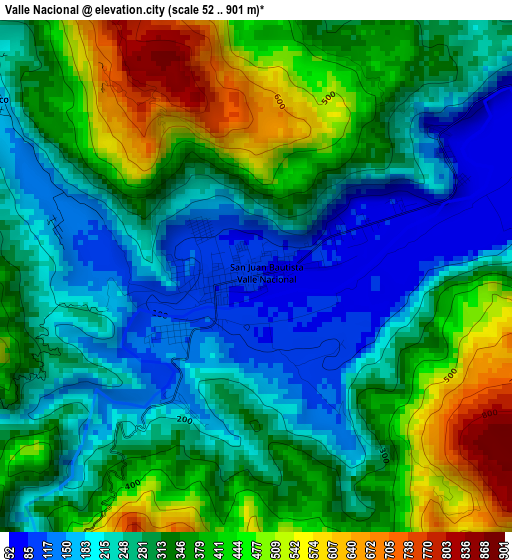
Below is the Elevation map of Valle Nacional, which displays elevation range with different colors. Scale of the first map is from 52 to 901 m (171 to 2956 ft) with average elevation of 320.8 meters (=1052 ft) [note 1]
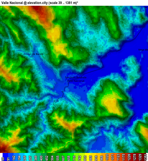
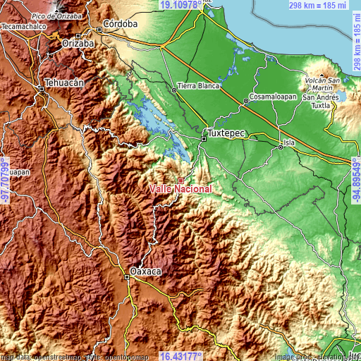
These maps also provides idea of topography and contour of this city, they are displayed at different zoom levels. More info about maps, scale and edge coordinates you can find below images.
| \ | Map #1 | Map #2 | Topo.Map |
| Scale [m] | 52..901 m | 39..1381 m | × |
| Scale [ft] | 171..2956 ft | 128..4531 ft | × |
| Average | 320.8 m = 1052 ft | 404.9 m = 1328 ft | × |
| Width | 9.31 km = 5.8 mi | 18.61 km = 11.6 mi | 297.8 km = 185 mi |
| Height | 9.31 km = 5.8 mi | 18.61 km = 11.6 mi | 297.8 km = 185 mi |
| ↑Max Latitude | 17.817632° | 17.859465° | 19.10978° |
| Latitude at center | 17.77579° | 17.77579° | 17.77579° |
| ↓Min Latitude | 17.733938° | 17.692076° | 16.43177° |
| ← Min Longitude | -96.345685° | -96.389631° | -97.70799° |
| Longitude center | -96.30174° | -96.30174° | -96.30174° |
| →Max Longitude | -96.257795° | -96.213849° | -94.89549° |
Nearby cities:
Cities around Valle Nacional sort by population:
• San Felipe Usila elevation 126 m
26.7 km,  297°
297°
• Ayotzintepec 124 m
21.6 km,  122°
122°
• San José Chiltepec 53 m
23.7 km,  36°
36°
• San Pedro Ozumacín 398 m
13.5 km,  143°
143°
• San Antonio las Palmas 119 m
25.2 km, 117°
• Arroyo Choápam 53 m
26.5 km, 35°
• Santa María Jacatepec 57 m
13.4 km,  45°
45°
• Vega del Sol 63 m
9.7 km,  67°
67°
• Arroyo de Banco 168 m
5.8 km, 301°
• Cerro Armadillo Grande 629 m
10.1 km,  355°
355°
• Paso Canoa 53 m
27.2 km,  14°
14°
• Santa Fe y la Mar 122 m
1.9 km,  234°
234°
Multilingual:
 En español:
Valle Nacional elevación 86 m.
 En France:
Valle Nacional élévation 86 m.
 Auf Deutsch:
Valle Nacional höhe über dem Meeresspiegel ist 86 m.

Sources and notes:
- [note 1] Map square and city borders are not equal. Map elevation data is calculated only from area inside that square.
- [src 1] Elevation data from geonames database provided with same terms of usage.
- [src 2] The elevation map of Valle Nacional is generated using elevation data from NASA's 3 arcsec (90m) resolution SRTM data.
- [src 3] Base (background) map © OpenStreetMap contributors tiles are generated by Geofabrik and OpenTopoMap.
Copyright & License:
This Valle Nacional Elevation Map is licensed under CC BY-SA. You may reuse any part from this page, if you give a proper credit by linking to this URL:
 More info on terms of use page.