San Felipe Usila elevation
San Felipe Usila (Oaxaca), Mexico elevation is 126 meters and San Felipe Usila elevation in feet is 413 ft above sea level [src 1]. San Felipe Usila is a seat of a second-order administrative division (feature code) with elevation that is 1188 meters (3898 ft) smaller than average city elevation in Mexico.
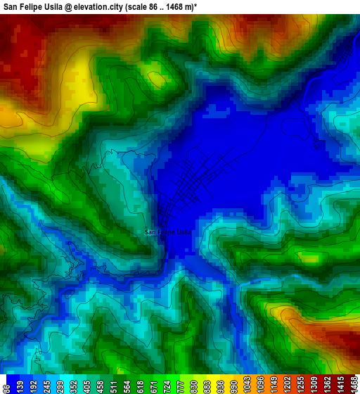
Below is the Elevation map of San Felipe Usila, which displays elevation range with different colors. Scale of the first map is from 86 to 1468 m (282 to 4816 ft) with average elevation of 501.6 meters (=1646 ft) [note 1]
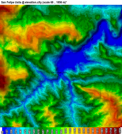
These maps also provides idea of topography and contour of this city, they are displayed at different zoom levels. More info about maps, scale and edge coordinates you can find below images.
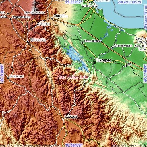
| \ | Map #1 | Map #2 | Topo.Map |
| Scale [m] | 86..1468 m | 68..1856 m | × |
| Scale [ft] | 282..4816 ft | 223..6089 ft | × |
| Average | 501.6 m = 1646 ft | 715.9 m = 2349 ft | × |
| Width | 9.3 km = 5.8 mi | 18.6 km = 11.6 mi | 297.6 km = 184.9 mi |
| Height | 9.3 km = 5.8 mi | 18.6 km = 11.6 mi | 297.6 km = 184.9 mi |
| ↑Max Latitude | 17.929716° | 17.971522° | 19.22102° |
| Latitude at center | 17.8879° | 17.8879° | 17.8879° |
| ↓Min Latitude | 17.846074° | 17.804238° | 16.54469° |
| ← Min Longitude | -96.568685° | -96.612631° | -97.93099° |
| Longitude center | -96.52474° | -96.52474° | -96.52474° |
| →Max Longitude | -96.480795° | -96.436849° | -95.11849° |
Nearby cities:
Cities around San Felipe Usila sort by population:
• San Felipe Jalapa de Díaz elevation 148 m
20.4 km,  356°
356°
• San Pedro Sochiápam 1252 m
16.1 km,  245°
245°
• Santo Tomás 208 m
17.2 km,  3°
3°
• San Andrés Teotilalpam 1527 m
15.7 km,  297°
297°
• Flor Batavia 452 m
10.8 km, 3°
• Playa Chica 94 m
19.3 km, 2°
• Arroyo de Banco 168 m
21 km,  116°
116°
• San Juan Sautla 1050 m
16.2 km,  258°
258°
• Arroyo Zapotillo 124 m
21.1 km,  354°
354°
• Tlacoatzintepec 548 m
7.2 km,  244°
244°
• San Juan Zapotitlán 605 m
12.6 km,  223°
223°
• San Pedro Teutila 1044 m
21.6 km, 297°
Multilingual:
 En español:
San Felipe, San Felipe Usila, Usila elevación 126 m.
 En France:
San Felipe Usila élévation 126 m.
 Auf Deutsch:
San Felipe Usila höhe über dem Meeresspiegel ist 126 m.

Sources and notes:
- [note 1] Map square and city borders are not equal. Map elevation data is calculated only from area inside that square.
- [src 1] Elevation data from geonames database provided with same terms of usage.
- [src 2] The elevation map of San Felipe Usila is generated using elevation data from NASA's 3 arcsec (90m) resolution SRTM data.
- [src 3] Base (background) map © OpenStreetMap contributors tiles are generated by Geofabrik and OpenTopoMap.
Copyright & License:
This San Felipe Usila Elevation Map is licensed under CC BY-SA. You may reuse any part from this page, if you give a proper credit by linking to this URL:
 More info on terms of use page.