San Pedro Quiatoni elevation
San Pedro Quiatoni (Oaxaca), Mexico elevation is 1852 meters and San Pedro Quiatoni elevation in feet is 6076 ft above sea level [src 1]. San Pedro Quiatoni is a seat of a second-order administrative division (feature code) with elevation that is 538 meters (1765 ft) bigger than average city elevation in Mexico.
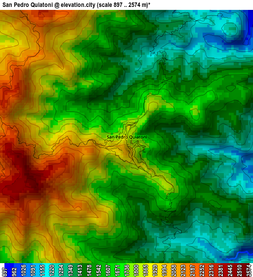
Below is the Elevation map of San Pedro Quiatoni, which displays elevation range with different colors. Scale of the first map is from 897 to 2574 m (2943 to 8445 ft) with average elevation of 1660.8 meters (=5449 ft) [note 1]
These maps also provides idea of topography and contour of this city, they are displayed at different zoom levels. More info about maps, scale and edge coordinates you can find below images.
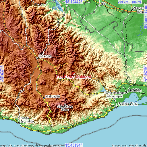
| \ | Map #1 | Topo.Map |
| Scale [m] | 897..2574 m | × |
| Scale [ft] | 2943..8445 ft | × |
| Average | 1660.8 m = 5449 ft | × |
| Width | 9.36 km = 5.8 mi | 299.4 km = 186 mi |
| Height | 9.36 km = 5.8 mi | 299.4 km = 186 mi |
| ↑Max Latitude | 16.825019° | 18.12442° |
| Latitude at center | 16.78295° | 16.78295° |
| ↓Min Latitude | 16.740872° | 15.43194° |
| ← Min Longitude | -96.074795° | -97.4371° |
| Longitude center | -96.03085° | -96.03085° |
| →Max Longitude | -95.986905° | -94.6246° |
Nearby cities:
Cities around San Pedro Quiatoni sort by population:
• San Baltazar Guelavila elevation 1607 m
29.3 km,  272°
272°
• Soledad Salinas 796 m
13.7 km,  167°
167°
• El Camarón 688 m
25.1 km,  179°
179°
• Ayutla 2070 m
27.6 km,  349°
349°
• Santo Domingo Tepuxtepec 2158 m
19.4 km, 351°
• San Juan Juquila 1427 m
20.8 km,  35°
35°
• Nejapa de Madero 654 m
20.5 km,  164°
164°
• San Lorenzo Albarradas 1824 m
28.1 km,  300°
300°
• San Juan del Río 1173 m
17.7 km,  309°
309°
• San Pedro Ocotepec 1627 m
27.5 km,  45°
45°
• Guadalupe Victoria 1008 m
23 km,  56°
56°
• Santa María Tepantlali 1829 m
23.9 km,  5°
5°
Multilingual:
 En español:
San Pedro Quiatoni elevación 1852 m.
 En France:
San Pedro Quiatoni élévation 1852 m.
 Auf Deutsch:
San Pedro Quiatoni höhe über dem Meeresspiegel ist 1852 m.
 На русском:
San Pedro Quiatoni высота над уровнем моря 1852 м
Sources and notes:
- [note 1] Map square and city borders are not equal. Map elevation data is calculated only from area inside that square.
- [src 1] Elevation data from geonames database provided with same terms of usage.
- [src 2] The elevation map of San Pedro Quiatoni is generated using elevation data from NASA's 3 arcsec (90m) resolution SRTM data.
- [src 3] Base (background) map © OpenStreetMap contributors tiles are generated by Geofabrik and OpenTopoMap.
Copyright & License:
This San Pedro Quiatoni Elevation Map is licensed under CC BY-SA. You may reuse any part from this page, if you give a proper credit by linking to this URL:
 More info on terms of use page.