San Juan Juquila elevation
San Juan Juquila (Oaxaca, San Juan Juquila Mixes), Mexico elevation is 1427 meters and San Juan Juquila elevation in feet is 4682 ft above sea level [src 1]. San Juan Juquila is a populated place (feature code) with elevation that is 113 meters (371 ft) bigger than average city elevation in Mexico.
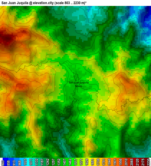
Below is the Elevation map of San Juan Juquila, which displays elevation range with different colors. Scale of the first map is from 803 to 2230 m (2635 to 7316 ft) with average elevation of 1480.2 meters (=4856 ft) [note 1]
These maps also provides idea of topography and contour of this city, they are displayed at different zoom levels. More info about maps, scale and edge coordinates you can find below images.
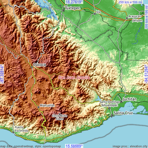
| \ | Map #1 | Topo.Map |
| Scale [m] | 803..2230 m | × |
| Scale [ft] | 2635..7316 ft | × |
| Average | 1480.2 m = 4856 ft | × |
| Width | 9.35 km = 5.8 mi | 299.1 km = 185.9 mi |
| Height | 9.35 km = 5.8 mi | 299.2 km = 185.9 mi |
| ↑Max Latitude | 16.977885° | 18.27619° |
| Latitude at center | 16.93585° | 16.93585° |
| ↓Min Latitude | 16.893806° | 15.58589° |
| ← Min Longitude | -95.962835° | -97.32514° |
| Longitude center | -95.91889° | -95.91889° |
| →Max Longitude | -95.874945° | -94.51264° |
Nearby cities:
Cities around San Juan Juquila sort by population:
• San Miguel Quetzaltepec elevation 1203 m
17.4 km,  75°
75°
• San Lucas Camotlán 1290 m
21.8 km,  87°
87°
• San Pedro Quiatoni 1852 m
20.8 km,  215°
215°
• Tamazulápam del Espíritu Santo 2079 m
20.4 km,  310°
310°
• Ayutla 2070 m
19.6 km,  301°
301°
• Santo Domingo Tepuxtepec 2158 m
15 km,  278°
278°
• Santiago Quiavicuzas 1393 m
23 km,  110°
110°
• San Pedro Ocotepec 1627 m
8.1 km,  74°
74°
• Guadalupe Victoria 1008 m
8.6 km,  120°
120°
• Santa María Tepantlali 1829 m
11.7 km, 305°
• Santa María Alotepec 1473 m
18.7 km,  21°
21°
• Tamazulapam 2079 m
20.4 km, 310°
Multilingual:
 En español:
San Juan Juquila elevación 1427 m.
 En France:
San Juan Juquila élévation 1427 m.
 Auf Deutsch:
San Juan Juquila höhe über dem Meeresspiegel ist 1427 m.

Sources and notes:
- [note 1] Map square and city borders are not equal. Map elevation data is calculated only from area inside that square.
- [src 1] Elevation data from geonames database provided with same terms of usage.
- [src 2] The elevation map of San Juan Juquila is generated using elevation data from NASA's 3 arcsec (90m) resolution SRTM data.
- [src 3] Base (background) map © OpenStreetMap contributors tiles are generated by Geofabrik and OpenTopoMap.
Copyright & License:
This San Juan Juquila Elevation Map is licensed under CC BY-SA. You may reuse any part from this page, if you give a proper credit by linking to this URL:
 More info on terms of use page.