Ayutla elevation
Ayutla (Oaxaca, San Pedro y San Pablo Ayutla), Mexico elevation is 2070 meters and Ayutla elevation in feet is 6791 ft above sea level [src 1]. Ayutla is a seat of a second-order administrative division (feature code) with elevation that is 756 meters (2480 ft) bigger than average city elevation in Mexico.
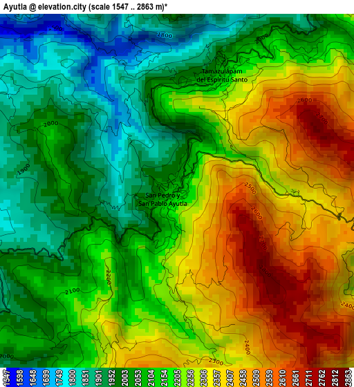
Below is the Elevation map of Ayutla, which displays elevation range with different colors. Scale of the first map is from 1547 to 2863 m (5075 to 9393 ft) with average elevation of 2171.5 meters (=7124 ft) [note 1]
These maps also provides idea of topography and contour of this city, they are displayed at different zoom levels. More info about maps, scale and edge coordinates you can find below images.
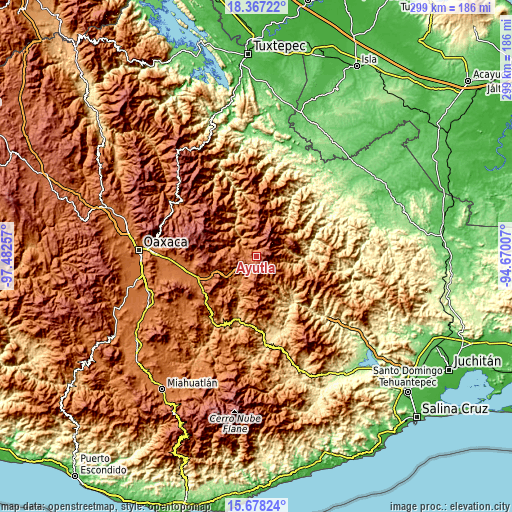
| \ | Map #1 | Topo.Map |
| Scale [m] | 1547..2863 m | × |
| Scale [ft] | 5075..9393 ft | × |
| Average | 2171.5 m = 7124 ft | × |
| Width | 9.34 km = 5.8 mi | 299 km = 185.8 mi |
| Height | 9.34 km = 5.8 mi | 299 km = 185.8 mi |
| ↑Max Latitude | 17.069574° | 18.36722° |
| Latitude at center | 17.02756° | 17.02756° |
| ↓Min Latitude | 16.985536° | 15.67824° |
| ← Min Longitude | -96.120265° | -97.48257° |
| Longitude center | -96.07632° | -96.07632° |
| →Max Longitude | -96.032375° | -94.67007° |
Nearby cities:
Cities around Ayutla sort by population:
• Tlahuitoltepec elevation 2249 m
7.9 km,  10°
10°
• Tamazulápam del Espíritu Santo 2079 m
3.3 km,  21°
21°
• Santiago Zacatepec 1402 m
22.6 km,  49°
49°
• Villa Hidalgo 1237 m
20.5 km,  328°
328°
• Santo Domingo Tepuxtepec 2158 m
8.2 km,  166°
166°
• San Juan Juquila 1427 m
19.6 km,  121°
121°
• San Juan del Río 1173 m
18.3 km,  209°
209°
• Yaganiza 1461 m
20.9 km,  308°
308°
• Santa María Tepantlali 1829 m
8 km, 115°
• Albarradas 1501 m
13.9 km,  288°
288°
• San Mateo Cajonos 1380 m
20.4 km,  316°
316°
• Tamazulapam 2079 m
3.3 km, 21°
Multilingual:
 En español:
Ayutla elevación 2070 m.
 En France:
Ayutla élévation 2070 m.


Sources and notes:
- [note 1] Map square and city borders are not equal. Map elevation data is calculated only from area inside that square.
- [src 1] Elevation data from geonames database provided with same terms of usage.
- [src 2] The elevation map of Ayutla is generated using elevation data from NASA's 3 arcsec (90m) resolution SRTM data.
- [src 3] Base (background) map © OpenStreetMap contributors tiles are generated by Geofabrik and OpenTopoMap.
Copyright & License:
This Ayutla Elevation Map is licensed under CC BY-SA. You may reuse any part from this page, if you give a proper credit by linking to this URL:
 More info on terms of use page.