Tlahuitoltepec elevation
Tlahuitoltepec (Oaxaca, Santa María Tlahuitoltepec), Mexico elevation is 2249 meters and Tlahuitoltepec elevation in feet is 7379 ft above sea level [src 1]. Tlahuitoltepec is a seat of a second-order administrative division (feature code) with elevation that is 935 meters (3068 ft) bigger than average city elevation in Mexico.
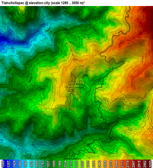
Below is the Elevation map of Tlahuitoltepec, which displays elevation range with different colors. Scale of the first map is from 1289 to 3050 m (4229 to 10007 ft) with average elevation of 2097.2 meters (=6881 ft) [note 1]
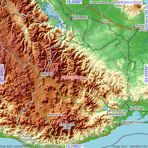
These maps also provides idea of topography and contour of this city, they are displayed at different zoom levels. More info about maps, scale and edge coordinates you can find below images.
| \ | Map #1 | Topo.Map |
| Scale [m] | 1289..3050 m | × |
| Scale [ft] | 4229..10007 ft | × |
| Average | 2097.2 m = 6881 ft | × |
| Width | 9.34 km = 5.8 mi | 298.9 km = 185.7 mi |
| Height | 9.34 km = 5.8 mi | 298.9 km = 185.7 mi |
| ↑Max Latitude | 17.139458° | 18.4366° |
| Latitude at center | 17.09746° | 17.09746° |
| ↓Min Latitude | 17.055452° | 15.74862° |
| ← Min Longitude | -96.106735° | -97.46904° |
| Longitude center | -96.06279° | -96.06279° |
| →Max Longitude | -96.018845° | -94.65654° |
Nearby cities:
Cities around Tlahuitoltepec sort by population:
• Tamazulápam del Espíritu Santo elevation 2079 m
4.7 km,  183°
183°
• Santiago Zacatepec 1402 m
17.2 km,  66°
66°
• Ayutla 2070 m
7.9 km,  190°
190°
• Villa Hidalgo 1237 m
15.6 km,  308°
308°
• Santo Domingo Tepuxtepec 2158 m
15.8 km, 178°
• Totontepec Villa de Morelos 1843 m
18.1 km,  11°
11°
• San Juan Metaltepec 1562 m
18.3 km,  61°
61°
• Yaganiza 1461 m
18.5 km,  286°
286°
• Santa María Tepantlali 1829 m
12.6 km,  152°
152°
• Albarradas 1501 m
15 km,  257°
257°
• San Mateo Cajonos 1380 m
17 km, 294°
• Tamazulapam 2079 m
4.7 km, 183°
Multilingual:
 En español:
Tlahuitoltepec elevación 2249 m.
 En France:
Tlahuitoltepec élévation 2249 m.
 Auf Deutsch:
Tlahuitoltepec höhe über dem Meeresspiegel ist 2249 m.

Sources and notes:
- [note 1] Map square and city borders are not equal. Map elevation data is calculated only from area inside that square.
- [src 1] Elevation data from geonames database provided with same terms of usage.
- [src 2] The elevation map of Tlahuitoltepec is generated using elevation data from NASA's 3 arcsec (90m) resolution SRTM data.
- [src 3] Base (background) map © OpenStreetMap contributors tiles are generated by Geofabrik and OpenTopoMap.
Copyright & License:
This Tlahuitoltepec Elevation Map is licensed under CC BY-SA. You may reuse any part from this page, if you give a proper credit by linking to this URL:
 More info on terms of use page.