Santiago Zacatepec elevation
Santiago Zacatepec (Oaxaca), Mexico elevation is 1402 meters and Santiago Zacatepec elevation in feet is 4600 ft above sea level [src 1]. Santiago Zacatepec is a populated place (feature code) with elevation that is 88 meters (289 ft) bigger than average city elevation in Mexico.
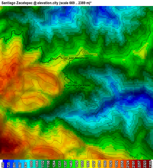
Below is the Elevation map of Santiago Zacatepec, which displays elevation range with different colors. Scale of the first map is from 669 to 2389 m (2195 to 7838 ft) with average elevation of 1363.9 meters (=4475 ft) [note 1]
These maps also provides idea of topography and contour of this city, they are displayed at different zoom levels. More info about maps, scale and edge coordinates you can find below images.
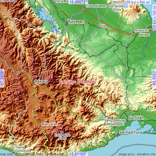
| \ | Map #1 | Topo.Map |
| Scale [m] | 669..2389 m | × |
| Scale [ft] | 2195..7838 ft | × |
| Average | 1363.9 m = 4475 ft | × |
| Width | 9.34 km = 5.8 mi | 298.8 km = 185.7 mi |
| Height | 9.34 km = 5.8 mi | 298.8 km = 185.7 mi |
| ↑Max Latitude | 17.202034° | 18.49872° |
| Latitude at center | 17.16005° | 17.16005° |
| ↓Min Latitude | 17.118056° | 15.81165° |
| ← Min Longitude | -95.958495° | -97.3208° |
| Longitude center | -95.91455° | -95.91455° |
| →Max Longitude | -95.870605° | -94.5083° |
Nearby cities:
Cities around Santiago Zacatepec sort by population:
• San Juan Cotzocón elevation 1240 m
14 km,  88°
88°
• Tlahuitoltepec 2249 m
17.2 km,  246°
246°
• Tamazulápam del Espíritu Santo 2079 m
19.8 km,  233°
233°
• Ayutla 2070 m
22.6 km, 229°
• Totontepec Villa de Morelos 1843 m
16.1 km,  311°
311°
• La Candelaria 927 m
6.8 km,  343°
343°
• San Juan Metaltepec 1562 m
1.8 km,  9°
9°
• San Pedro Ocotepec 1627 m
23.9 km,  162°
162°
• Santiago Choápam 911 m
22.3 km,  357°
357°
• Santa María Tepantlali 1829 m
20.8 km,  208°
208°
• Santa María Alotepec 1473 m
9.9 km,  139°
139°
• Tamazulapam 2079 m
19.8 km, 233°
Multilingual:
 En español:
Santiago Zacatepec elevación 1402 m.
 En France:
Santiago Zacatepec élévation 1402 m.
 Auf Deutsch:
Santiago Zacatepec höhe über dem Meeresspiegel ist 1402 m.
 На русском:
Santiago Zacatepec высота над уровнем моря 1402 м
Sources and notes:
- [note 1] Map square and city borders are not equal. Map elevation data is calculated only from area inside that square.
- [src 1] Elevation data from geonames database provided with same terms of usage.
- [src 2] The elevation map of Santiago Zacatepec is generated using elevation data from NASA's 3 arcsec (90m) resolution SRTM data.
- [src 3] Base (background) map © OpenStreetMap contributors tiles are generated by Geofabrik and OpenTopoMap.
Copyright & License:
This Santiago Zacatepec Elevation Map is licensed under CC BY-SA. You may reuse any part from this page, if you give a proper credit by linking to this URL:
 More info on terms of use page.