El Camarón elevation
El Camarón (Oaxaca, Nejapa de Madero), Mexico elevation is 688 meters and El Camarón elevation in feet is 2257 ft above sea level [src 1]. El Camarón is a populated place (feature code) with elevation that is 626 meters (2054 ft) smaller than average city elevation in Mexico.
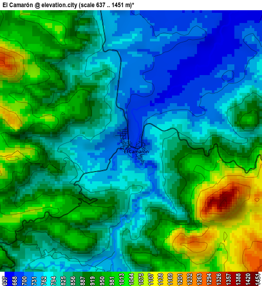
Below is the Elevation map of El Camarón, which displays elevation range with different colors. Scale of the first map is from 637 to 1451 m (2090 to 4760 ft) with average elevation of 872.4 meters (=2862 ft) [note 1]
These maps also provides idea of topography and contour of this city, they are displayed at different zoom levels. More info about maps, scale and edge coordinates you can find below images.
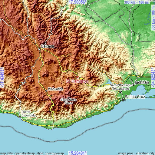
| \ | Map #1 | Topo.Map |
| Scale [m] | 637..1451 m | × |
| Scale [ft] | 2090..4760 ft | × |
| Average | 872.4 m = 2862 ft | × |
| Width | 9.37 km = 5.8 mi | 299.7 km = 186.2 mi |
| Height | 9.37 km = 5.8 mi | 299.8 km = 186.3 mi |
| ↑Max Latitude | 16.599568° | 17.90056° |
| Latitude at center | 16.55745° | 16.55745° |
| ↓Min Latitude | 16.515322° | 15.20491° |
| ← Min Longitude | -96.072625° | -97.43493° |
| Longitude center | -96.02868° | -96.02868° |
| →Max Longitude | -95.984735° | -94.62243° |
Nearby cities:
Cities around El Camarón sort by population:
• Soledad Salinas elevation 796 m
12 km,  13°
13°
• San Pedro Quiatoni 1852 m
25.1 km,  359°
359°
• Santa María Zoquitlán 1037 m
34.6 km,  270°
270°
• San Pedro Totolápam 961 m
32.2 km,  292°
292°
• Nejapa de Madero 654 m
7.6 km,  44°
44°
• San José Lachiguirí 1694 m
38.4 km,  238°
238°
• San Carlos Yautepec 887 m
10.7 km,  230°
230°
• Santa María Quiegolani 2153 m
31.3 km,  184°
184°
• San Pedro Mártir Quiechapa 1827 m
27.9 km, 235°
• San Bartolo Yautepec 870 m
15.4 km,  157°
157°
• Santa María Ecatepec 1830 m
34.2 km,  152°
152°
• Santa Catalina Quieri 1965 m
36.5 km,  223°
223°
Multilingual:
 En español:
El Camarón elevación 688 m.
 En France:
El Camarón élévation 688 m.
 Auf Deutsch:
El Camarón höhe über dem Meeresspiegel ist 688 m.

Sources and notes:
- [note 1] Map square and city borders are not equal. Map elevation data is calculated only from area inside that square.
- [src 1] Elevation data from geonames database provided with same terms of usage.
- [src 2] The elevation map of El Camarón is generated using elevation data from NASA's 3 arcsec (90m) resolution SRTM data.
- [src 3] Base (background) map © OpenStreetMap contributors tiles are generated by Geofabrik and OpenTopoMap.
Copyright & License:
This El Camarón Elevation Map is licensed under CC BY-SA. You may reuse any part from this page, if you give a proper credit by linking to this URL:
 More info on terms of use page.