San Simón Almolongas elevation
San Simón Almolongas (Oaxaca), Mexico elevation is 1521 meters and San Simón Almolongas elevation in feet is 4990 ft above sea level [src 1]. San Simón Almolongas is a seat of a second-order administrative division (feature code) with elevation that is 207 meters (679 ft) bigger than average city elevation in Mexico.
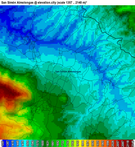
Below is the Elevation map of San Simón Almolongas, which displays elevation range with different colors. Scale of the first map is from 1357 to 2148 m (4452 to 7047 ft) with average elevation of 1554.3 meters (=5099 ft) [note 1]
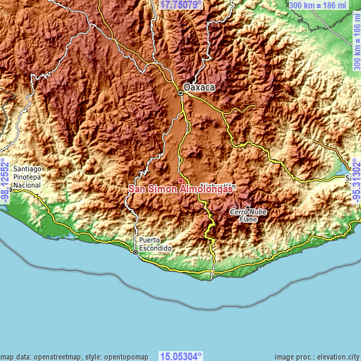
These maps also provides idea of topography and contour of this city, they are displayed at different zoom levels. More info about maps, scale and edge coordinates you can find below images.
| \ | Map #1 | Topo.Map |
| Scale [m] | 1357..2148 m | × |
| Scale [ft] | 4452..7047 ft | × |
| Average | 1554.3 m = 5099 ft | × |
| Width | 9.37 km = 5.8 mi | 300 km = 186.4 mi |
| Height | 9.37 km = 5.8 mi | 300 km = 186.4 mi |
| ↑Max Latitude | 16.448741° | 17.75079° |
| Latitude at center | 16.40659° | 16.40659° |
| ↓Min Latitude | 16.36443° | 15.05304° |
| ← Min Longitude | -96.763215° | -98.12552° |
| Longitude center | -96.71927° | -96.71927° |
| →Max Longitude | -96.675325° | -95.31302° |
Nearby cities:
Cities around San Simón Almolongas sort by population:
• Miahuatlán de Porfirio Díaz elevation 1554 m
15.5 km,  121°
121°
• Ejutla de Crespo 1448 m
17.8 km,  355°
355°
• Santa Cruz Xitla 1791 m
10.5 km,  152°
152°
• San Vicente Coatlán 1379 m
13.4 km,  261°
261°
• Coatecas Altas 1557 m
15.7 km,  20°
20°
• Santa Ana 1597 m
7.3 km,  178°
178°
• Santa Catarina Cuixtla 1768 m
13.9 km,  143°
143°
• San Agustín Amatengo 1366 m
13.8 km,  327°
327°
• Santiago Yogana 1361 m
9.5 km,  309°
309°
• Santa María Velato 1735 m
13.4 km,  36°
36°
• Guixé 1577 m
7.3 km,  14°
14°
• San Nicolás 1455 m
2.8 km,  302°
302°
Multilingual:
 En español:
San Simón Almolongas elevación 1521 m.
 En France:
San Simón Almolongas élévation 1521 m.
 Auf Deutsch:
San Simón Almolongas höhe über dem Meeresspiegel ist 1521 m.
 На русском:
San Simón Almolongas высота над уровнем моря 1521 м
Sources and notes:
- [note 1] Map square and city borders are not equal. Map elevation data is calculated only from area inside that square.
- [src 1] Elevation data from geonames database provided with same terms of usage.
- [src 2] The elevation map of San Simón Almolongas is generated using elevation data from NASA's 3 arcsec (90m) resolution SRTM data.
- [src 3] Base (background) map © OpenStreetMap contributors tiles are generated by Geofabrik and OpenTopoMap.
Copyright & License:
This San Simón Almolongas Elevation Map is licensed under CC BY-SA. You may reuse any part from this page, if you give a proper credit by linking to this URL:
 More info on terms of use page.