San Vicente Coatlán elevation
San Vicente Coatlán (Oaxaca), Mexico elevation is 1379 meters and San Vicente Coatlán elevation in feet is 4524 ft above sea level [src 1]. San Vicente Coatlán is a seat of a second-order administrative division (feature code) with elevation that is 65 meters (213 ft) bigger than average city elevation in Mexico.
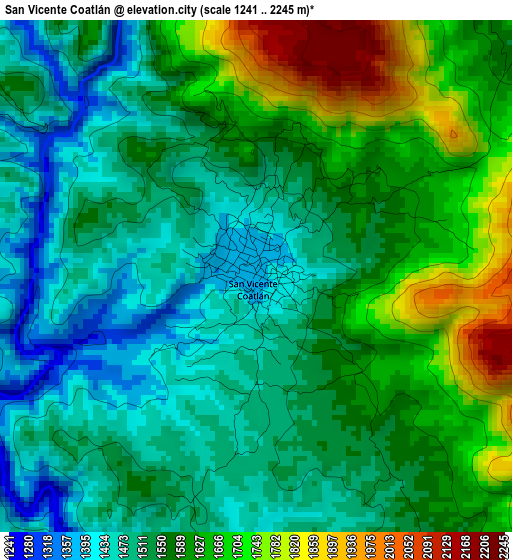
Below is the Elevation map of San Vicente Coatlán, which displays elevation range with different colors. Scale of the first map is from 1241 to 2245 m (4072 to 7365 ft) with average elevation of 1567.7 meters (=5143 ft) [note 1]
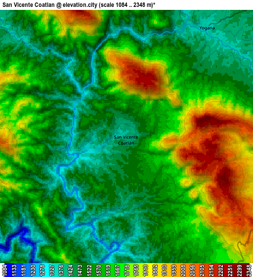
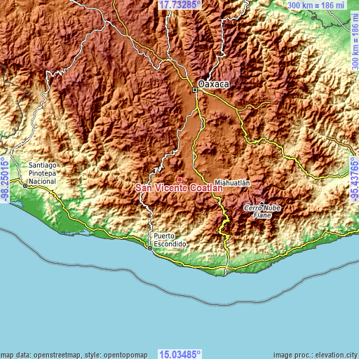
These maps also provides idea of topography and contour of this city, they are displayed at different zoom levels. More info about maps, scale and edge coordinates you can find below images.
| \ | Map #1 | Map #2 | Topo.Map |
| Scale [m] | 1241..2245 m | 1084..2348 m | × |
| Scale [ft] | 4072..7365 ft | 3556..7703 ft | × |
| Average | 1567.7 m = 5143 ft | 1604.9 m = 5265 ft | × |
| Width | 9.38 km = 5.8 mi | 18.75 km = 11.7 mi | 300 km = 186.4 mi |
| Height | 9.38 km = 5.8 mi | 18.75 km = 11.7 mi | 300 km = 186.4 mi |
| ↑Max Latitude | 16.430675° | 16.472821° | 17.73285° |
| Latitude at center | 16.38852° | 16.38852° | 16.38852° |
| ↓Min Latitude | 16.346356° | 16.304182° | 15.03485° |
| ← Min Longitude | -96.887845° | -96.931791° | -98.25015° |
| Longitude center | -96.8439° | -96.8439° | -96.8439° |
| →Max Longitude | -96.799955° | -96.756009° | -95.43765° |
Nearby cities:
Cities around San Vicente Coatlán sort by population:
• Santa Cruz Xitla elevation 1791 m
19.6 km,  111°
111°
• Santa Ana 1597 m
14.5 km, 111°
• Villa Sola de Vega 1443 m
20.3 km,  315°
315°
• San Agustín Amatengo 1366 m
14.8 km,  23°
23°
• Santiago Yogana 1361 m
10.1 km,  36°
36°
• San Simón Almolongas 1521 m
13.4 km,  81°
81°
• San Sebastián Coatlán 1983 m
20.8 km,  174°
174°
• San Francisco Sola 1419 m
19.9 km, 315°
• Guixé 1577 m
17.6 km,  58°
58°
• San Jerónimo Coatlán 1722 m
17.6 km,  189°
189°
• San Nicolás 1455 m
11.5 km,  72°
72°
• San Pablo Coatlán 1484 m
19.4 km,  160°
160°
Multilingual:
 En español:
San Vicente Coatlán elevación 1379 m.
 En France:
San Vicente Coatlán élévation 1379 m.
 Auf Deutsch:
San Vicente Coatlán höhe über dem Meeresspiegel ist 1379 m.
 На русском:
San Vicente Coatlán высота над уровнем моря 1379 м
Sources and notes:
- [note 1] Map square and city borders are not equal. Map elevation data is calculated only from area inside that square.
- [src 1] Elevation data from geonames database provided with same terms of usage.
- [src 2] The elevation map of San Vicente Coatlán is generated using elevation data from NASA's 3 arcsec (90m) resolution SRTM data.
- [src 3] Base (background) map © OpenStreetMap contributors tiles are generated by Geofabrik and OpenTopoMap.
Copyright & License:
This San Vicente Coatlán Elevation Map is licensed under CC BY-SA. You may reuse any part from this page, if you give a proper credit by linking to this URL:
 More info on terms of use page.