Guixé elevation
Guixé (Oaxaca, Miahuatlán de Porfirio Díaz), Mexico elevation is 1577 meters and Guixé elevation in feet is 5174 ft above sea level [src 1]. Guixé is a populated place (feature code) with elevation that is 263 meters (863 ft) bigger than average city elevation in Mexico.
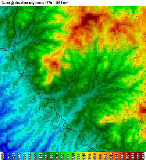
Below is the Elevation map of Guixé, which displays elevation range with different colors. Scale of the first map is from 1379 to 1931 m (4524 to 6335 ft) with average elevation of 1599.6 meters (=5248 ft) [note 1]
These maps also provides idea of topography and contour of this city, they are displayed at different zoom levels. More info about maps, scale and edge coordinates you can find below images.
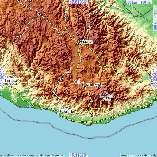
| \ | Map #1 | Topo.Map |
| Scale [m] | 1379..1931 m | × |
| Scale [ft] | 4524..6335 ft | × |
| Average | 1599.6 m = 5248 ft | × |
| Width | 9.37 km = 5.8 mi | 299.9 km = 186.3 mi |
| Height | 9.37 km = 5.8 mi | 299.9 km = 186.3 mi |
| ↑Max Latitude | 16.512048° | 17.81366° |
| Latitude at center | 16.46991° | 16.46991° |
| ↓Min Latitude | 16.427763° | 15.11678° |
| ← Min Longitude | -96.746655° | -98.10896° |
| Longitude center | -96.70271° | -96.70271° |
| →Max Longitude | -96.658765° | -95.29646° |
Nearby cities:
Cities around Guixé sort by population:
• Ejutla de Crespo elevation 1448 m
11.1 km,  344°
344°
• Santa Cruz Xitla 1791 m
16.6 km,  169°
169°
• Coatecas Altas 1557 m
8.5 km,  25°
25°
• Santa Ana 1597 m
14.4 km,  186°
186°
• San Agustín Amatengo 1366 m
10.3 km,  296°
296°
• Santiago Yogana 1361 m
9.1 km,  263°
263°
• San Simón Almolongas 1521 m
7.3 km, 194°
• Santa María Velato 1735 m
7.2 km,  58°
58°
• Agua del Espino 1434 m
17.1 km,  321°
321°
• San Miguel Ejutla 1454 m
12.9 km, 342°
• San Nicolás 1455 m
6.9 km,  216°
216°
• Taniche 1412 m
12.3 km,  333°
333°
Multilingual:
 En español:
Guixé elevación 1577 m.
 En France:
Guixé élévation 1577 m.


Sources and notes:
- [note 1] Map square and city borders are not equal. Map elevation data is calculated only from area inside that square.
- [src 1] Elevation data from geonames database provided with same terms of usage.
- [src 2] The elevation map of Guixé is generated using elevation data from NASA's 3 arcsec (90m) resolution SRTM data.
- [src 3] Base (background) map © OpenStreetMap contributors tiles are generated by Geofabrik and OpenTopoMap.
Copyright & License:
This Guixé Elevation Map is licensed under CC BY-SA. You may reuse any part from this page, if you give a proper credit by linking to this URL:
 More info on terms of use page.