Tlacotepec elevation
Tlacotepec (Morelos, Zacualpan), Mexico elevation is 1775 meters and Tlacotepec elevation in feet is 5823 ft above sea level [src 1]. Tlacotepec is a populated place (feature code) with elevation that is 461 meters (1512 ft) bigger than average city elevation in Mexico.
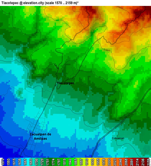
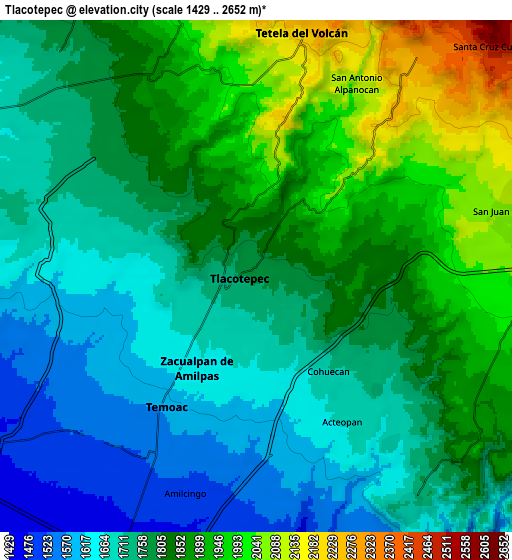
Below is the Elevation map of Tlacotepec, which displays elevation range with different colors. Scale of the first map is from 1570 to 2159 m (5151 to 7083 ft) with average elevation of 1779.2 meters (=5837 ft) [note 1]
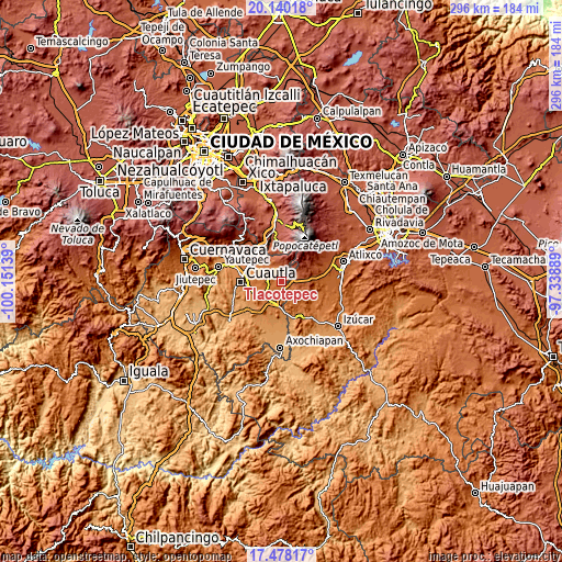
These maps also provides idea of topography and contour of this city, they are displayed at different zoom levels. More info about maps, scale and edge coordinates you can find below images.
| \ | Map #1 | Map #2 | Topo.Map |
| Scale [m] | 1570..2159 m | 1429..2652 m | × |
| Scale [ft] | 5151..7083 ft | 4688..8701 ft | × |
| Average | 1779.2 m = 5837 ft | 1797.5 m = 5897 ft | × |
| Width | 9.25 km = 5.7 mi | 18.5 km = 11.5 mi | 296 km = 183.9 mi |
| Height | 9.25 km = 5.7 mi | 18.5 km = 11.5 mi | 296 km = 183.9 mi |
| ↑Max Latitude | 18.856032° | 18.897614° | 20.14018° |
| Latitude at center | 18.81444° | 18.81444° | 18.81444° |
| ↓Min Latitude | 18.772838° | 18.731225° | 17.47817° |
| ← Min Longitude | -98.789085° | -98.833031° | -100.15139° |
| Longitude center | -98.74514° | -98.74514° | -98.74514° |
| →Max Longitude | -98.701195° | -98.657249° | -97.33889° |
Nearby cities:
Cities around Tlacotepec sort by population:
• Tetela del Volcán elevation 2222 m
8.9 km,  10°
10°
• Temoac 1588 m
5.8 km,  215°
215°
• Ocuituco 1934 m
7.6 km,  337°
337°
• San Juan Amecac 2079 m
9.3 km,  76°
76°
• Huazulco 1546 m
7.5 km,  204°
204°
• Amilcingo 1507 m
8.4 km, 198°
• Zacualpan de Amilpas 1649 m
4 km,  212°
212°
• San Antonio Alpanocan 2096 m
7.9 km,  27°
27°
• Metepec 2052 m
7.2 km,  358°
358°
• Acteopan 1666 m
6.5 km,  149°
149°
• Cohuecán 1706 m
4.4 km,  144°
144°
• Tecajec 1584 m
7.6 km,  256°
256°
Multilingual:
 En español:
Tlacotepec elevación 1775 m.
 En France:
Tlacotepec élévation 1775 m.
 Auf Deutsch:
Tlacotepec höhe über dem Meeresspiegel ist 1775 m.

Sources and notes:
- [note 1] Map square and city borders are not equal. Map elevation data is calculated only from area inside that square.
- [src 1] Elevation data from geonames database provided with same terms of usage.
- [src 2] The elevation map of Tlacotepec is generated using elevation data from NASA's 3 arcsec (90m) resolution SRTM data.
- [src 3] Base (background) map © OpenStreetMap contributors tiles are generated by Geofabrik and OpenTopoMap.
Copyright & License:
This Tlacotepec Elevation Map is licensed under CC BY-SA. You may reuse any part from this page, if you give a proper credit by linking to this URL:
 More info on terms of use page.