Tetela del Volcán elevation
Tetela del Volcán (Morelos), Mexico elevation is 2222 meters and Tetela del Volcán elevation in feet is 7290 ft above sea level [src 1]. Tetela del Volcán is a populated place (feature code) with elevation that is 908 meters (2979 ft) bigger than average city elevation in Mexico.
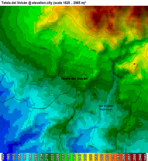
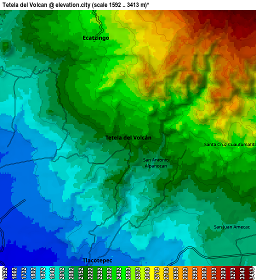
Below is the Elevation map of Tetela del Volcán, which displays elevation range with different colors. Scale of the first map is from 1820 to 2985 m (5971 to 9793 ft) with average elevation of 2237.4 meters (=7341 ft) [note 1]
These maps also provides idea of topography and contour of this city, they are displayed at different zoom levels. More info about maps, scale and edge coordinates you can find below images.
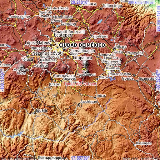
| \ | Map #1 | Map #2 | Topo.Map |
| Scale [m] | 1820..2985 m | 1592..3413 m | × |
| Scale [ft] | 5971..9793 ft | 5223..11198 ft | × |
| Average | 2237.4 m = 7341 ft | 2227.7 m = 7309 ft | × |
| Width | 9.25 km = 5.7 mi | 18.49 km = 11.5 mi | 295.8 km = 183.8 mi |
| Height | 9.25 km = 5.7 mi | 18.49 km = 11.5 mi | 295.9 km = 183.9 mi |
| ↑Max Latitude | 18.934633° | 18.976195° | 20.21816° |
| Latitude at center | 18.89306° | 18.89306° | 18.89306° |
| ↓Min Latitude | 18.851477° | 18.809884° | 17.55739° |
| ← Min Longitude | -98.773665° | -98.817611° | -100.13597° |
| Longitude center | -98.72972° | -98.72972° | -98.72972° |
| →Max Longitude | -98.685775° | -98.641829° | -97.32347° |
Nearby cities:
Cities around Tetela del Volcán sort by population:
• Ecatzingo de Hidalgo elevation 2393 m
7.3 km,  341°
341°
• Hueyapan 2360 m
5 km,  94°
94°
• Ocuituco 1934 m
4.9 km,  249°
249°
• Jumiltepec 2148 m
5.4 km,  294°
294°
• San Antonio Alpanocan 2096 m
2.7 km,  131°
131°
• Metepec 2052 m
2.4 km,  228°
228°
• Huecahuasco 2095 m
7.4 km,  311°
311°
• Texcala 2011 m
8.2 km,  303°
303°
• Santa Cruz Cuautomatitla 2519 m
7.4 km, 93°
• Ocoxaltepec 2374 m
5.2 km,  332°
332°
• San Juan Tlacotompa (Tlacotompa) 2082 m
8.3 km, 309°
• Huepalcalco (San Miguel) 2286 m
2.8 km, 309°
Multilingual:
 En español:
Tetela del Volcán elevación 2222 m.
 En France:
Tetela del Volcán élévation 2222 m.
 Auf Deutsch:
Tetela del Volcán höhe über dem Meeresspiegel ist 2222 m.
 На русском:
Tetela del Volcán высота над уровнем моря 2222 м
Sources and notes:
- [note 1] Map square and city borders are not equal. Map elevation data is calculated only from area inside that square.
- [src 1] Elevation data from geonames database provided with same terms of usage.
- [src 2] The elevation map of Tetela del Volcán is generated using elevation data from NASA's 3 arcsec (90m) resolution SRTM data.
- [src 3] Base (background) map © OpenStreetMap contributors tiles are generated by Geofabrik and OpenTopoMap.
Copyright & License:
This Tetela del Volcán Elevation Map is licensed under CC BY-SA. You may reuse any part from this page, if you give a proper credit by linking to this URL:
 More info on terms of use page.