Ocuituco elevation
Ocuituco (Morelos), Mexico elevation is 1934 meters and Ocuituco elevation in feet is 6345 ft above sea level [src 1]. Ocuituco is a seat of a second-order administrative division (feature code) with elevation that is 620 meters (2034 ft) bigger than average city elevation in Mexico.
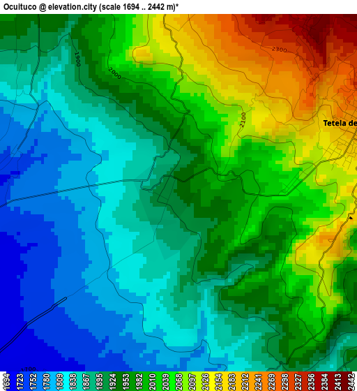
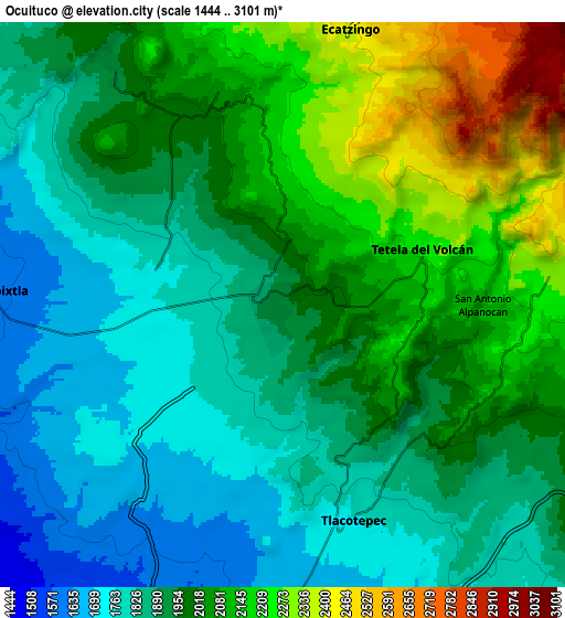
Below is the Elevation map of Ocuituco, which displays elevation range with different colors. Scale of the first map is from 1694 to 2442 m (5558 to 8012 ft) with average elevation of 1948.7 meters (=6393 ft) [note 1]
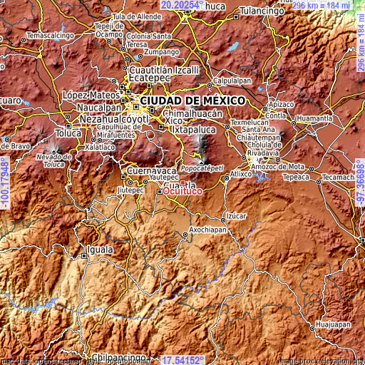
These maps also provides idea of topography and contour of this city, they are displayed at different zoom levels. More info about maps, scale and edge coordinates you can find below images.
| \ | Map #1 | Map #2 | Topo.Map |
| Scale [m] | 1694..2442 m | 1444..3101 m | × |
| Scale [ft] | 5558..8012 ft | 4738..10174 ft | × |
| Average | 1948.7 m = 6393 ft | 1973.1 m = 6473 ft | × |
| Width | 9.25 km = 5.7 mi | 18.49 km = 11.5 mi | 295.9 km = 183.9 mi |
| Height | 9.25 km = 5.7 mi | 18.49 km = 11.5 mi | 295.9 km = 183.9 mi |
| ↑Max Latitude | 18.918886° | 18.960453° | 20.20254° |
| Latitude at center | 18.87731° | 18.87731° | 18.87731° |
| ↓Min Latitude | 18.835723° | 18.794126° | 17.54152° |
| ← Min Longitude | -98.817175° | -98.861121° | -100.17948° |
| Longitude center | -98.77323° | -98.77323° | -98.77323° |
| →Max Longitude | -98.729285° | -98.685339° | -97.36698° |
Nearby cities:
Cities around Ocuituco sort by population:
• Tetela del Volcán elevation 2222 m
4.9 km,  69°
69°
• Ecatzingo de Hidalgo 2393 m
8.9 km,  14°
14°
• Tlacotepec 1775 m
7.6 km,  157°
157°
• Jumiltepec 2148 m
4.1 km,  354°
354°
• San Antonio Alpanocan 2096 m
6.6 km,  90°
90°
• Xochitlán 1764 m
4.3 km,  287°
287°
• Metepec 2052 m
2.8 km, 86°
• Huecahuasco 2095 m
6.7 km, 351°
• Texcala 2011 m
6.7 km,  340°
340°
• Ocoxaltepec 2374 m
6.8 km,  18°
18°
• San Juan Tlacotompa (Tlacotompa) 2082 m
7.3 km, 345°
• Huepalcalco (San Miguel) 2286 m
4.3 km,  34°
34°
Multilingual:
 En español:
Ocuituco elevación 1934 m.
 En France:
Ocuituco élévation 1934 m.
 Auf Deutsch:
Ocuituco höhe über dem Meeresspiegel ist 1934 m.

Sources and notes:
- [note 1] Map square and city borders are not equal. Map elevation data is calculated only from area inside that square.
- [src 1] Elevation data from geonames database provided with same terms of usage.
- [src 2] The elevation map of Ocuituco is generated using elevation data from NASA's 3 arcsec (90m) resolution SRTM data.
- [src 3] Base (background) map © OpenStreetMap contributors tiles are generated by Geofabrik and OpenTopoMap.
Copyright & License:
This Ocuituco Elevation Map is licensed under CC BY-SA. You may reuse any part from this page, if you give a proper credit by linking to this URL:
 More info on terms of use page.