Tlalcozotitlán elevation
Tlalcozotitlán (Guerrero, Copalillo), Mexico elevation is 574 meters and Tlalcozotitlán elevation in feet is 1883 ft above sea level [src 1]. Tlalcozotitlán is a populated place (feature code) with elevation that is 740 meters (2428 ft) smaller than average city elevation in Mexico.
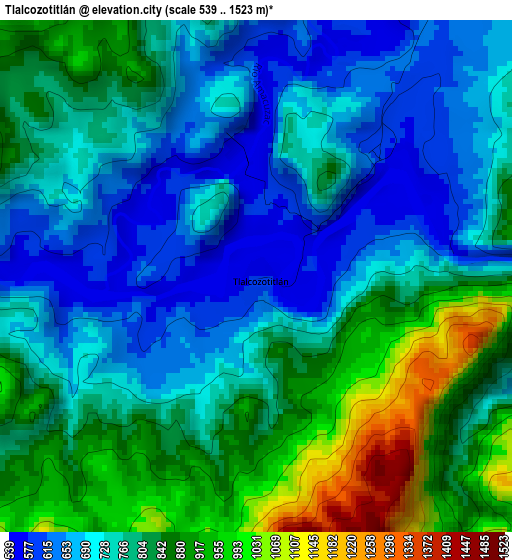
Below is the Elevation map of Tlalcozotitlán, which displays elevation range with different colors. Scale of the first map is from 539 to 1523 m (1768 to 4997 ft) with average elevation of 781.2 meters (=2563 ft) [note 1]
These maps also provides idea of topography and contour of this city, they are displayed at different zoom levels. More info about maps, scale and edge coordinates you can find below images.
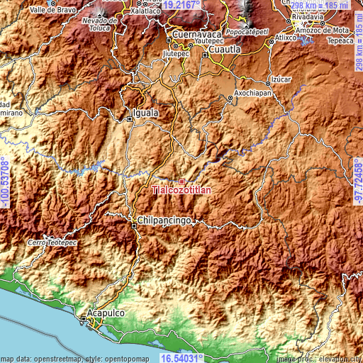
| \ | Map #1 | Topo.Map |
| Scale [m] | 539..1523 m | × |
| Scale [ft] | 1768..4997 ft | × |
| Average | 781.2 m = 2563 ft | × |
| Width | 9.3 km = 5.8 mi | 297.6 km = 184.9 mi |
| Height | 9.3 km = 5.8 mi | 297.6 km = 184.9 mi |
| ↑Max Latitude | 17.925367° | 19.2167° |
| Latitude at center | 17.88355° | 17.88355° |
| ↓Min Latitude | 17.841723° | 16.54031° |
| ← Min Longitude | -99.174775° | -100.53708° |
| Longitude center | -99.13083° | -99.13083° |
| →Max Longitude | -99.086885° | -97.72458° |
Nearby cities:
Cities around Tlalcozotitlán sort by population:
• Copalillo elevation 886 m
19.3 km,  29°
29°
• Zitlala 1369 m
22.3 km,  195°
195°
• Tulimán 1101 m
20.9 km,  320°
320°
• San Juan Totolcintla 585 m
20.9 km,  277°
277°
• La Esperanza 1568 m
18.4 km,  221°
221°
• Xocoyolzintla 1290 m
24.7 km,  140°
140°
• Tlaltempanapa 1400 m
17.1 km, 196°
• San Francisco Ozomatlán 534 m
22.5 km, 281°
• San Francisco Oxtutla 614 m
17.7 km,  60°
60°
• Rancho de las Lomas 1600 m
20.1 km, 217°
• Yetlancingo 1640 m
18.1 km,  174°
174°
• Tecolcuautla 1059 m
22.1 km,  119°
119°
Multilingual:
 En español:
Tlalcozotitlán elevación 574 m.
 En France:
Tlalcozotitlán élévation 574 m.
 Auf Deutsch:
Tlalcozotitlán höhe über dem Meeresspiegel ist 574 m.

Sources and notes:
- [note 1] Map square and city borders are not equal. Map elevation data is calculated only from area inside that square.
- [src 1] Elevation data from geonames database provided with same terms of usage.
- [src 2] The elevation map of Tlalcozotitlán is generated using elevation data from NASA's 3 arcsec (90m) resolution SRTM data.
- [src 3] Base (background) map © OpenStreetMap contributors tiles are generated by Geofabrik and OpenTopoMap.
Copyright & License:
This Tlalcozotitlán Elevation Map is licensed under CC BY-SA. You may reuse any part from this page, if you give a proper credit by linking to this URL:
 More info on terms of use page.