Zitlala elevation
Zitlala (Guerrero), Mexico elevation is 1369 meters and Zitlala elevation in feet is 4491 ft above sea level [src 1]. Zitlala is a seat of a second-order administrative division (feature code) with elevation that is 55 meters (180 ft) bigger than average city elevation in Mexico.
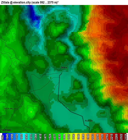
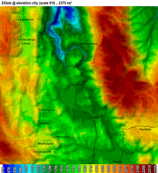
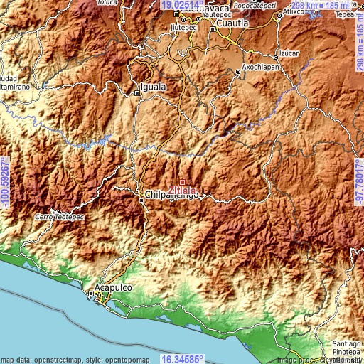
Below is the Elevation map of Zitlala, which displays elevation range with different colors. Scale of the first map is from 992 to 2375 m (3255 to 7792 ft) with average elevation of 1592.9 meters (=5226 ft) [note 1]
These maps also provides idea of topography and contour of this city, they are displayed at different zoom levels. More info about maps, scale and edge coordinates you can find below images.
| \ | Map #1 | Map #2 | Topo.Map |
| Scale [m] | 992..2375 m | 816..2375 m | × |
| Scale [ft] | 3255..7792 ft | 2677..7792 ft | × |
| Average | 1592.9 m = 5226 ft | 1685.2 m = 5529 ft | × |
| Width | 9.31 km = 5.8 mi | 18.62 km = 11.6 mi | 297.9 km = 185.1 mi |
| Height | 9.31 km = 5.8 mi | 18.62 km = 11.6 mi | 297.9 km = 185.1 mi |
| ↑Max Latitude | 17.732352° | 17.774205° | 19.02514° |
| Latitude at center | 17.69049° | 17.69049° | 17.69049° |
| ↓Min Latitude | 17.648618° | 17.606736° | 16.34585° |
| ← Min Longitude | -99.230365° | -99.274311° | -100.59267° |
| Longitude center | -99.18642° | -99.18642° | -99.18642° |
| →Max Longitude | -99.142475° | -99.098529° | -97.78017° |
Nearby cities:
Cities around Zitlala sort by population:
• Nejapa elevation 1364 m
9.6 km,  152°
152°
• Acatlán 1363 m
4 km, 153°
• Pochahuizco 1554 m
4.8 km,  233°
233°
• Topiltepec 1507 m
5.9 km,  220°
220°
• Pantitlán 1830 m
9.9 km,  124°
124°
• La Mohonera 1500 m
6 km,  196°
196°
• Tlaltempanapa 1400 m
5.2 km,  10°
10°
• Ahuihuiyuco 1653 m
8 km,  212°
212°
• Tepozcuautla 1672 m
8.8 km, 209°
• Rancho de las Lomas 1600 m
8.3 km,  311°
311°
• Yetlancingo 1640 m
8.3 km,  65°
65°
• Lodo Grande 1528 m
9.4 km, 196°
Multilingual:
 En español:
Zitlala elevación 1369 m.
 En France:
Zitlala élévation 1369 m.
 Auf Deutsch:
Zitlala höhe über dem Meeresspiegel ist 1369 m.

Sources and notes:
- [note 1] Map square and city borders are not equal. Map elevation data is calculated only from area inside that square.
- [src 1] Elevation data from geonames database provided with same terms of usage.
- [src 2] The elevation map of Zitlala is generated using elevation data from NASA's 3 arcsec (90m) resolution SRTM data.
- [src 3] Base (background) map © OpenStreetMap contributors tiles are generated by Geofabrik and OpenTopoMap.
Copyright & License:
This Zitlala Elevation Map is licensed under CC BY-SA. You may reuse any part from this page, if you give a proper credit by linking to this URL:
 More info on terms of use page.