Nejapa elevation
Nejapa (Guerrero, Chilapa de Álvarez), Mexico elevation is 1364 meters and Nejapa elevation in feet is 4475 ft above sea level [src 1]. Nejapa is a populated place (feature code) with elevation that is 50 meters (164 ft) bigger than average city elevation in Mexico.
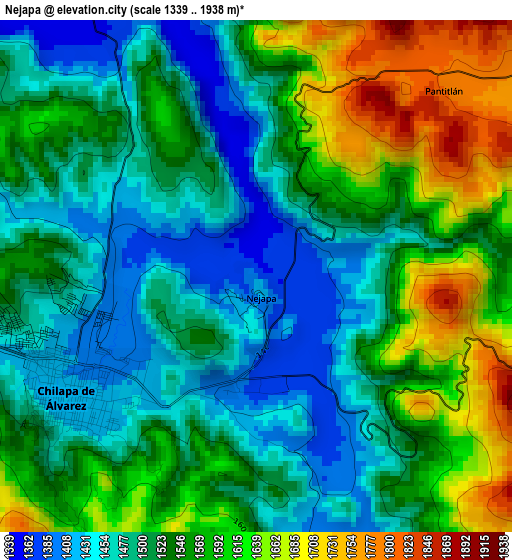
Below is the Elevation map of Nejapa, which displays elevation range with different colors. Scale of the first map is from 1339 to 1938 m (4393 to 6358 ft) with average elevation of 1537.9 meters (=5046 ft) [note 1]
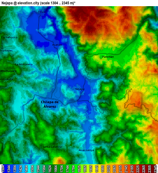
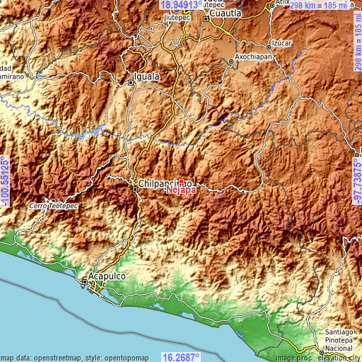
These maps also provides idea of topography and contour of this city, they are displayed at different zoom levels. More info about maps, scale and edge coordinates you can find below images.
| \ | Map #1 | Map #2 | Topo.Map |
| Scale [m] | 1339..1938 m | 1304..2345 m | × |
| Scale [ft] | 4393..6358 ft | 4278..7694 ft | × |
| Average | 1537.9 m = 5046 ft | 1677.2 m = 5503 ft | × |
| Width | 9.31 km = 5.8 mi | 18.63 km = 11.6 mi | 298 km = 185.2 mi |
| Height | 9.31 km = 5.8 mi | 18.63 km = 11.6 mi | 298.1 km = 185.2 mi |
| ↑Max Latitude | 17.65577° | 17.697641° | 18.94913° |
| Latitude at center | 17.61389° | 17.61389° | 17.61389° |
| ↓Min Latitude | 17.572° | 17.530101° | 16.2687° |
| ← Min Longitude | -99.188945° | -99.232891° | -100.55125° |
| Longitude center | -99.145° | -99.145° | -99.145° |
| →Max Longitude | -99.101055° | -99.057109° | -97.73875° |
Nearby cities:
Cities around Nejapa sort by population:
• Chilapa de Álvarez elevation 1430 m
3.5 km,  241°
241°
• Zitlala 1369 m
9.6 km,  332°
332°
• Acatlán 1363 m
5.6 km, 332°
• Topiltepec 1507 m
9.2 km,  296°
296°
• Pantitlán 1830 m
4.7 km,  52°
52°
• Atzacoaloya 1424 m
7.5 km,  173°
173°
• Santa Catarina 1699 m
8 km,  203°
203°
• La Mohonera 1500 m
6.6 km,  294°
294°
• Tlacoaxtla 1583 m
8.8 km,  222°
222°
• Ahuihuiyuco 1653 m
8.9 km,  281°
281°
• Tepozcuautla 1672 m
8.8 km, 276°
• Lodo Grande 1528 m
7.1 km,  266°
266°
Multilingual:
 En español:
Nejapa elevación 1364 m.
 En France:
Nejapa élévation 1364 m.


Sources and notes:
- [note 1] Map square and city borders are not equal. Map elevation data is calculated only from area inside that square.
- [src 1] Elevation data from geonames database provided with same terms of usage.
- [src 2] The elevation map of Nejapa is generated using elevation data from NASA's 3 arcsec (90m) resolution SRTM data.
- [src 3] Base (background) map © OpenStreetMap contributors tiles are generated by Geofabrik and OpenTopoMap.
Copyright & License:
This Nejapa Elevation Map is licensed under CC BY-SA. You may reuse any part from this page, if you give a proper credit by linking to this URL:
 More info on terms of use page.