San Francisco Ozomatlán elevation
San Francisco Ozomatlán (Guerrero, Huitzuco de los Figueroa), Mexico elevation is 534 meters and San Francisco Ozomatlán elevation in feet is 1752 ft above sea level [src 1]. San Francisco Ozomatlán is a populated place (feature code) with elevation that is 780 meters (2559 ft) smaller than average city elevation in Mexico.
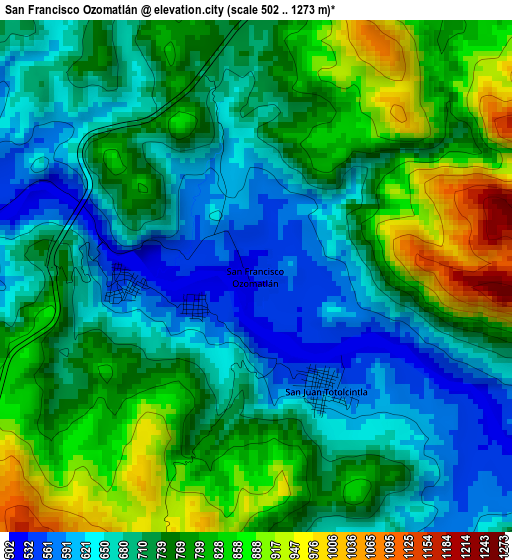
Below is the Elevation map of San Francisco Ozomatlán, which displays elevation range with different colors. Scale of the first map is from 502 to 1273 m (1647 to 4177 ft) with average elevation of 738.7 meters (=2424 ft) [note 1]
These maps also provides idea of topography and contour of this city, they are displayed at different zoom levels. More info about maps, scale and edge coordinates you can find below images.
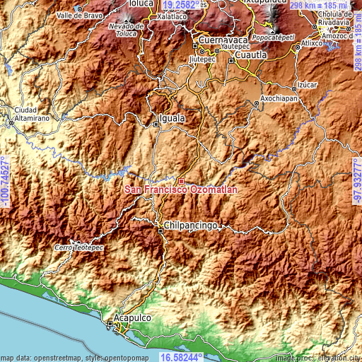
| \ | Map #1 | Topo.Map |
| Scale [m] | 502..1273 m | × |
| Scale [ft] | 1647..4177 ft | × |
| Average | 738.7 m = 2424 ft | × |
| Width | 9.3 km = 5.8 mi | 297.5 km = 184.9 mi |
| Height | 9.3 km = 5.8 mi | 297.5 km = 184.9 mi |
| ↑Max Latitude | 17.967177° | 19.2582° |
| Latitude at center | 17.92537° | 17.92537° |
| ↓Min Latitude | 17.883553° | 16.58244° |
| ← Min Longitude | -99.382965° | -100.74527° |
| Longitude center | -99.33902° | -99.33902° |
| →Max Longitude | -99.295075° | -97.93277° |
Nearby cities:
Cities around San Francisco Ozomatlán sort by population:
• Apango elevation 1097 m
20.5 km,  177°
177°
• Tulimán 1101 m
14.5 km,  37°
37°
• San Juan Totolcintla 585 m
2.4 km,  148°
148°
• La Esperanza 1568 m
20.8 km, 152°
• San Agustín Oapan 514 m
10.9 km,  286°
286°
• San Miguel Tecuiciapan 529 m
9 km,  296°
296°
• Xalitla 557 m
23.2 km, 290°
• Axaxacualco 1467 m
18.7 km,  223°
223°
• Tlanipatla 1494 m
17.7 km, 222°
• Rancho de las Lomas 1600 m
22.9 km, 154°
• Ahuehuepan 867 m
19.3 km, 297°
• Tlalcozotitlán 574 m
22.5 km,  101°
101°
Multilingual:
 En español:
San Francisco Ozomatlán elevación 534 m.
 En France:
San Francisco Ozomatlán élévation 534 m.
 Auf Deutsch:
San Francisco Ozomatlán höhe über dem Meeresspiegel ist 534 m.
 На русском:
San Francisco Ozomatlán высота над уровнем моря 534 м
Sources and notes:
- [note 1] Map square and city borders are not equal. Map elevation data is calculated only from area inside that square.
- [src 1] Elevation data from geonames database provided with same terms of usage.
- [src 2] The elevation map of San Francisco Ozomatlán is generated using elevation data from NASA's 3 arcsec (90m) resolution SRTM data.
- [src 3] Base (background) map © OpenStreetMap contributors tiles are generated by Geofabrik and OpenTopoMap.
Copyright & License:
This San Francisco Ozomatlán Elevation Map is licensed under CC BY-SA. You may reuse any part from this page, if you give a proper credit by linking to this URL:
 More info on terms of use page.