Tlatlauquitepec elevation
Tlatlauquitepec (Guerrero, Atlixtac), Mexico elevation is 2111 meters and Tlatlauquitepec elevation in feet is 6926 ft above sea level [src 1]. Tlatlauquitepec is a populated place (feature code) with elevation that is 797 meters (2615 ft) bigger than average city elevation in Mexico.
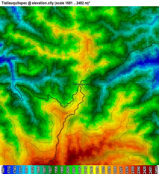
Below is the Elevation map of Tlatlauquitepec, which displays elevation range with different colors. Scale of the first map is from 1681 to 2482 m (5515 to 8143 ft) with average elevation of 2045.4 meters (=6711 ft) [note 1]
These maps also provides idea of topography and contour of this city, they are displayed at different zoom levels. More info about maps, scale and edge coordinates you can find below images.
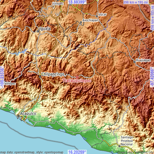
| \ | Map #1 | Topo.Map |
| Scale [m] | 1681..2482 m | × |
| Scale [ft] | 5515..8143 ft | × |
| Average | 2045.4 m = 6711 ft | × |
| Width | 9.32 km = 5.8 mi | 298.1 km = 185.2 mi |
| Height | 9.32 km = 5.8 mi | 298.2 km = 185.3 mi |
| ↑Max Latitude | 17.590145° | 18.88399° |
| Latitude at center | 17.54825° | 17.54825° |
| ↓Min Latitude | 17.506345° | 16.20259° |
| ← Min Longitude | -98.871055° | -100.23336° |
| Longitude center | -98.82711° | -98.82711° |
| →Max Longitude | -98.783165° | -97.42086° |
Nearby cities:
Cities around Tlatlauquitepec sort by population:
• Atlixtac elevation 1679 m
11.5 km,  278°
278°
• Copanatoyac 1377 m
15.3 km,  128°
128°
• Chiepetepec 1789 m
10.1 km,  78°
78°
• Alpuyecancingo de las Montañas 1483 m
13.9 km,  349°
349°
• Zapotitlán Tablas 1804 m
14.7 km,  160°
160°
• Ayotzinapa 1598 m
6.8 km, 82°
• San Miguel Axoxuca 1383 m
17.5 km,  89°
89°
• Santa Anita 1571 m
17.8 km,  139°
139°
• San Pedro Huitzapula Norte (Huitzapula Norte) 1867 m
13.7 km,  170°
170°
• Patlicha 1423 m
16.5 km, 137°
• Pochutla 1156 m
14.4 km,  328°
328°
• Coachimalco 1812 m
17.7 km,  61°
61°
Multilingual:
 En español:
Tlatlauquitepec elevación 2111 m.
 En France:
Tlatlauquitepec élévation 2111 m.
 Auf Deutsch:
Tlatlauquitepec höhe über dem Meeresspiegel ist 2111 m.

Sources and notes:
- [note 1] Map square and city borders are not equal. Map elevation data is calculated only from area inside that square.
- [src 1] Elevation data from geonames database provided with same terms of usage.
- [src 2] The elevation map of Tlatlauquitepec is generated using elevation data from NASA's 3 arcsec (90m) resolution SRTM data.
- [src 3] Base (background) map © OpenStreetMap contributors tiles are generated by Geofabrik and OpenTopoMap.
Copyright & License:
This Tlatlauquitepec Elevation Map is licensed under CC BY-SA. You may reuse any part from this page, if you give a proper credit by linking to this URL:
 More info on terms of use page.