Atlixtac elevation
Atlixtac (Guerrero), Mexico elevation is 1679 meters and Atlixtac elevation in feet is 5509 ft above sea level [src 1]. Atlixtac is a seat of a second-order administrative division (feature code) with elevation that is 365 meters (1198 ft) bigger than average city elevation in Mexico.
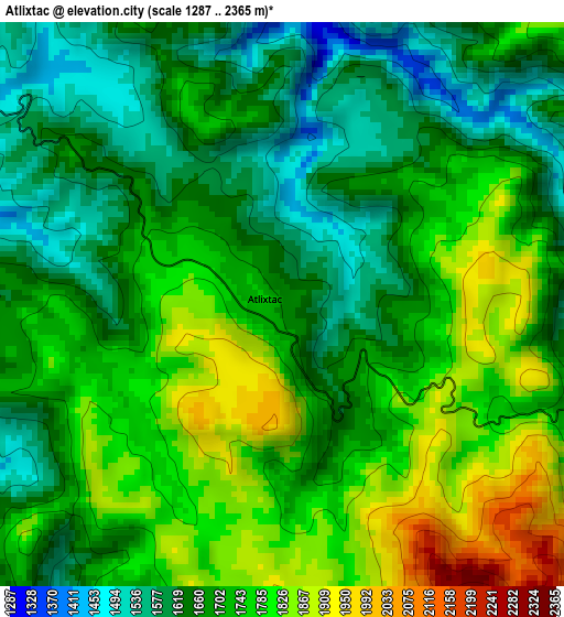
Below is the Elevation map of Atlixtac, which displays elevation range with different colors. Scale of the first map is from 1287 to 2365 m (4222 to 7759 ft) with average elevation of 1711.2 meters (=5614 ft) [note 1]
These maps also provides idea of topography and contour of this city, they are displayed at different zoom levels. More info about maps, scale and edge coordinates you can find below images.
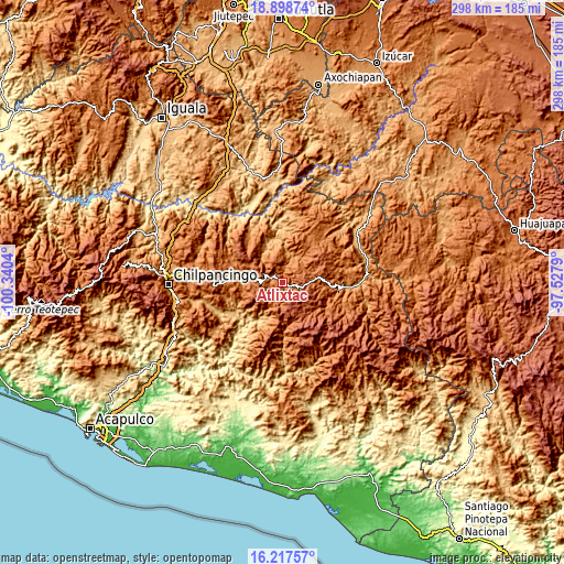
| \ | Map #1 | Topo.Map |
| Scale [m] | 1287..2365 m | × |
| Scale [ft] | 4222..7759 ft | × |
| Average | 1711.2 m = 5614 ft | × |
| Width | 9.32 km = 5.8 mi | 298.1 km = 185.2 mi |
| Height | 9.32 km = 5.8 mi | 298.1 km = 185.2 mi |
| ↑Max Latitude | 17.605012° | 18.89874° |
| Latitude at center | 17.56312° | 17.56312° |
| ↓Min Latitude | 17.521218° | 16.21757° |
| ← Min Longitude | -98.978095° | -100.3404° |
| Longitude center | -98.93415° | -98.93415° |
| →Max Longitude | -98.890205° | -97.5279° |
Nearby cities:
Cities around Atlixtac sort by population:
• Ahuacuotzingo elevation 1480 m
16.8 km,  359°
359°
• Pantitlán 1830 m
20.5 km,  294°
294°
• Tlatlauquitepec 2111 m
11.5 km,  98°
98°
• Alpuyecancingo de las Montañas 1483 m
14.8 km,  36°
36°
• Hueycantenango 1644 m
15.9 km,  216°
216°
• Ayotzinapa 1598 m
18.1 km,  92°
92°
• Xocoyolzintla 1290 m
17.4 km,  343°
343°
• Ixcatla 1495 m
17.1 km,  203°
203°
• San Pedro Huitzapula Norte (Huitzapula Norte) 1867 m
20.4 km,  138°
138°
• Alcozacán 1878 m
18.3 km,  249°
249°
• Oztotitlán 1269 m
15.5 km,  321°
321°
• Pochutla 1156 m
11.3 km,  19°
19°
Multilingual:
 En español:
Atlixtac elevación 1679 m.
 En France:
Atlixtac élévation 1679 m.
 Auf Deutsch:
Atlixtac höhe über dem Meeresspiegel ist 1679 m.

Sources and notes:
- [note 1] Map square and city borders are not equal. Map elevation data is calculated only from area inside that square.
- [src 1] Elevation data from geonames database provided with same terms of usage.
- [src 2] The elevation map of Atlixtac is generated using elevation data from NASA's 3 arcsec (90m) resolution SRTM data.
- [src 3] Base (background) map © OpenStreetMap contributors tiles are generated by Geofabrik and OpenTopoMap.
Copyright & License:
This Atlixtac Elevation Map is licensed under CC BY-SA. You may reuse any part from this page, if you give a proper credit by linking to this URL:
 More info on terms of use page.