Coachimalco elevation
Coachimalco (Guerrero, Tlapa de Comonfort), Mexico elevation is 1812 meters and Coachimalco elevation in feet is 5945 ft above sea level [src 1]. Coachimalco is a populated place (feature code) with elevation that is 498 meters (1634 ft) bigger than average city elevation in Mexico.
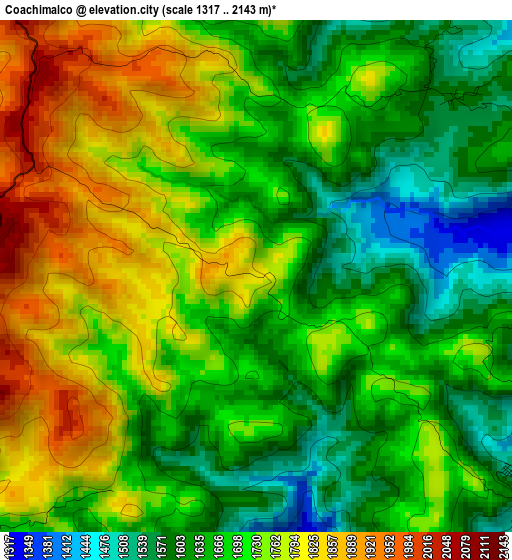
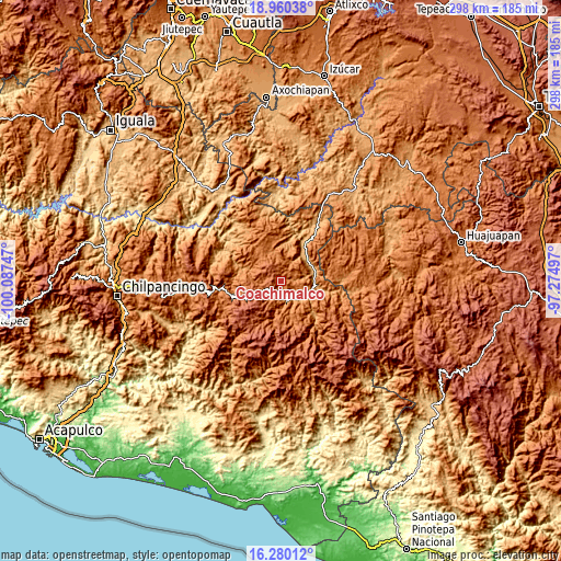
Below is the Elevation map of Coachimalco, which displays elevation range with different colors. Scale of the first map is from 1317 to 2143 m (4321 to 7031 ft) with average elevation of 1704.7 meters (=5593 ft) [note 1]
These maps also provides idea of topography and contour of this city, they are displayed at different zoom levels. More info about maps, scale and edge coordinates you can find below images.
| \ | Map #1 | Topo.Map |
| Scale [m] | 1317..2143 m | × |
| Scale [ft] | 4321..7031 ft | × |
| Average | 1704.7 m = 5593 ft | × |
| Width | 9.31 km = 5.8 mi | 298 km = 185.2 mi |
| Height | 9.31 km = 5.8 mi | 298 km = 185.2 mi |
| ↑Max Latitude | 17.667108° | 18.96038° |
| Latitude at center | 17.62523° | 17.62523° |
| ↓Min Latitude | 17.583343° | 16.28012° |
| ← Min Longitude | -98.725165° | -100.08747° |
| Longitude center | -98.68122° | -98.68122° |
| →Max Longitude | -98.637275° | -97.27497° |
Nearby cities:
Cities around Coachimalco sort by population:
• Tlapa de Comonfort elevation 1092 m
14.3 km,  128°
128°
• Chiepetepec 1789 m
8.6 km,  219°
219°
• Cualác 1458 m
13.3 km,  9°
9°
• Atlamajac 1061 m
16.2 km,  118°
118°
• Ayotzinapa 1598 m
11.6 km,  228°
228°
• San Miguel Axoxuca 1383 m
8.7 km,  166°
166°
• Tlatzala 1498 m
14 km,  94°
94°
• Ahuatepec Pueblo 1414 m
9.9 km,  102°
102°
• Chiaucingo 1378 m
13.1 km,  352°
352°
• Atlamajalcingo del Río 1150 m
11.3 km, 166°
• Colonia Constitución 1208 m
13.1 km,  138°
138°
• Coyahualco 914 m
17.7 km,  43°
43°
Multilingual:
 En español:
Coachimalco elevación 1812 m.
 En France:
Coachimalco élévation 1812 m.
 Auf Deutsch:
Coachimalco höhe über dem Meeresspiegel ist 1812 m.

Sources and notes:
- [note 1] Map square and city borders are not equal. Map elevation data is calculated only from area inside that square.
- [src 1] Elevation data from geonames database provided with same terms of usage.
- [src 2] The elevation map of Coachimalco is generated using elevation data from NASA's 3 arcsec (90m) resolution SRTM data.
- [src 3] Base (background) map © OpenStreetMap contributors tiles are generated by Geofabrik and OpenTopoMap.
Copyright & License:
This Coachimalco Elevation Map is licensed under CC BY-SA. You may reuse any part from this page, if you give a proper credit by linking to this URL:
 More info on terms of use page.