Tlaxco elevation
Tlaxco (Tlaxcala), Mexico elevation is 2550 meters and Tlaxco elevation in feet is 8366 ft above sea level [src 1]. Tlaxco is a seat of a second-order administrative division (feature code) with elevation that is 1236 meters (4055 ft) bigger than average city elevation in Mexico.
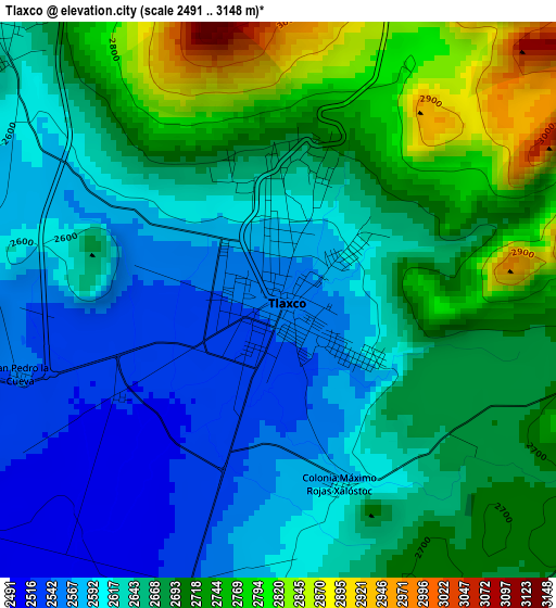
Below is the Elevation map of Tlaxco, which displays elevation range with different colors. Scale of the first map is from 2491 to 3148 m (8173 to 10328 ft) with average elevation of 2659.1 meters (=8724 ft) [note 1]
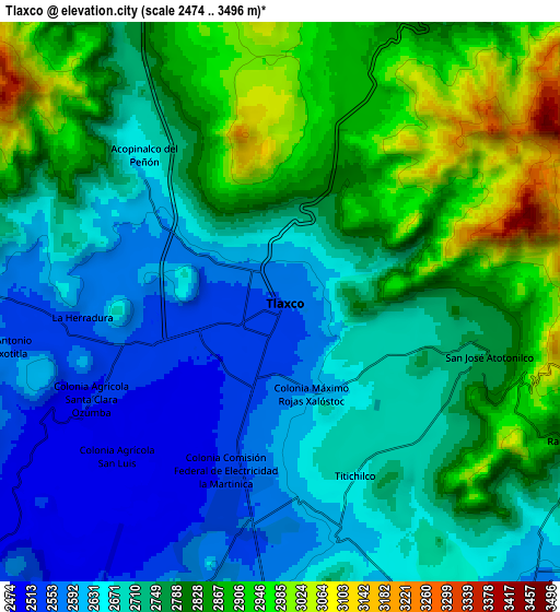
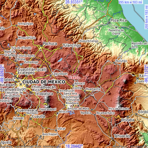
These maps also provides idea of topography and contour of this city, they are displayed at different zoom levels. More info about maps, scale and edge coordinates you can find below images.
| \ | Map #1 | Map #2 | Topo.Map |
| Scale [m] | 2491..3148 m | 2474..3496 m | × |
| Scale [ft] | 8173..10328 ft | 8117..11470 ft | × |
| Average | 2659.1 m = 8724 ft | 2752 m = 9029 ft | × |
| Width | 9.21 km = 5.7 mi | 18.41 km = 11.4 mi | 294.6 km = 183.1 mi |
| Height | 9.21 km = 5.7 mi | 18.41 km = 11.4 mi | 294.6 km = 183.1 mi |
| ↑Max Latitude | 19.65581° | 19.697189° | 20.93351° |
| Latitude at center | 19.61442° | 19.61442° | 19.61442° |
| ↓Min Latitude | 19.573019° | 19.531608° | 18.28442° |
| ← Min Longitude | -98.163915° | -98.207861° | -99.52622° |
| Longitude center | -98.11997° | -98.11997° | -98.11997° |
| →Max Longitude | -98.076025° | -98.032079° | -96.71372° |
Nearby cities:
Cities around Tlaxco sort by population:
• Atexcatzingo elevation 2509 m
16.4 km,  189°
189°
• Lázaro Cárdenas 2521 m
16.8 km,  120°
120°
• Acopinalco del Peñón 2650 m
6.7 km,  317°
317°
• El Rosario 2704 m
12.5 km,  294°
294°
• Lagunilla 2591 m
16.3 km,  278°
278°
• Capula 2603 m
11.9 km,  136°
136°
• San Pedro Ecatepec 2590 m
10.9 km,  199°
199°
• Zumpango 2605 m
12.6 km,  239°
239°
• San Antonio Matlahuacales 2527 m
16.2 km,  14°
14°
• San José Tepeyahualco 2560 m
15.7 km,  263°
263°
• Calpanería Atezquilla 2825 m
13.8 km,  70°
70°
• Atlangatepec 2507 m
13.1 km,  225°
225°
Multilingual:
 En español:
Tlaxco elevación 2550 m.
 En France:
Tlaxco élévation 2550 m.


Sources and notes:
- [note 1] Map square and city borders are not equal. Map elevation data is calculated only from area inside that square.
- [src 1] Elevation data from geonames database provided with same terms of usage.
- [src 2] The elevation map of Tlaxco is generated using elevation data from NASA's 3 arcsec (90m) resolution SRTM data.
- [src 3] Base (background) map © OpenStreetMap contributors tiles are generated by Geofabrik and OpenTopoMap.
Copyright & License:
This Tlaxco Elevation Map is licensed under CC BY-SA. You may reuse any part from this page, if you give a proper credit by linking to this URL:
 More info on terms of use page.