Acopinalco del Peñón elevation
Acopinalco del Peñón (Tlaxcala, Tlaxco), Mexico elevation is 2650 meters and Acopinalco del Peñón elevation in feet is 8694 ft above sea level [src 1]. Acopinalco del Peñón is a populated place (feature code) with elevation that is 1336 meters (4383 ft) bigger than average city elevation in Mexico.
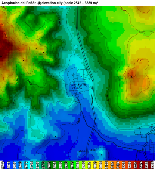
Below is the Elevation map of Acopinalco del Peñón, which displays elevation range with different colors. Scale of the first map is from 2542 to 3389 m (8340 to 11119 ft) with average elevation of 2812.2 meters (=9226 ft) [note 1]
These maps also provides idea of topography and contour of this city, they are displayed at different zoom levels. More info about maps, scale and edge coordinates you can find below images.
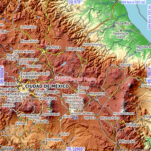
| \ | Map #1 | Topo.Map |
| Scale [m] | 2542..3389 m | × |
| Scale [ft] | 8340..11119 ft | × |
| Average | 2812.2 m = 9226 ft | × |
| Width | 9.2 km = 5.7 mi | 294.5 km = 183 mi |
| Height | 9.2 km = 5.7 mi | 294.5 km = 183 mi |
| ↑Max Latitude | 19.700668° | 20.978° |
| Latitude at center | 19.65929° | 19.65929° |
| ↓Min Latitude | 19.617901° | 18.32965° |
| ← Min Longitude | -98.206935° | -99.56924° |
| Longitude center | -98.16299° | -98.16299° |
| →Max Longitude | -98.119045° | -96.75674° |
Nearby cities:
Cities around Acopinalco del Peñón sort by population:
• Tlaxco elevation 2550 m
6.7 km,  137°
137°
• El Rosario 2704 m
6.9 km,  271°
271°
• Lagunilla 2591 m
11.9 km,  257°
257°
• San Pedro Ecatepec 2590 m
15.3 km,  176°
176°
• Zumpango 2605 m
13 km,  209°
209°
• San Antonio Matlahuacales 2527 m
13.6 km,  38°
38°
• Villa Cuauhtémoc 2407 m
14.9 km,  27°
27°
• San José Tepeyahualco 2560 m
12.9 km,  239°
239°
• Calpanería Atezquilla 2825 m
17.6 km,  91°
91°
• San Lorenzo Sóltepec 2536 m
16.9 km,  248°
248°
• Matlahuacales Aquiles Serdán 2416 m
16.2 km,  45°
45°
• Atlangatepec 2507 m
14.9 km,  198°
198°
Multilingual:
 En español:
El Peñón elevación 2650 m.
 En France:
Acopinalco del Peñón élévation 2650 m.
 Auf Deutsch:
Acopinalco del Peñón höhe über dem Meeresspiegel ist 2650 m.
 На русском:
Acopinalco del Peñón высота над уровнем моря 2650 м
Sources and notes:
- [note 1] Map square and city borders are not equal. Map elevation data is calculated only from area inside that square.
- [src 1] Elevation data from geonames database provided with same terms of usage.
- [src 2] The elevation map of Acopinalco del Peñón is generated using elevation data from NASA's 3 arcsec (90m) resolution SRTM data.
- [src 3] Base (background) map © OpenStreetMap contributors tiles are generated by Geofabrik and OpenTopoMap.
Copyright & License:
This Acopinalco del Peñón Elevation Map is licensed under CC BY-SA. You may reuse any part from this page, if you give a proper credit by linking to this URL:
 More info on terms of use page.