Zumpango elevation
Zumpango (Tlaxcala, Atlangatepec), Mexico elevation is 2605 meters and Zumpango elevation in feet is 8547 ft above sea level [src 1]. Zumpango is a populated place (feature code) with elevation that is 1291 meters (4236 ft) bigger than average city elevation in Mexico.
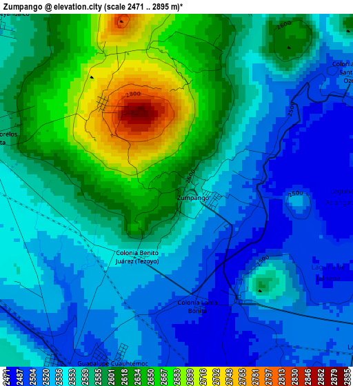
Below is the Elevation map of Zumpango, which displays elevation range with different colors. Scale of the first map is from 2471 to 2895 m (8107 to 9498 ft) with average elevation of 2568.9 meters (=8428 ft) [note 1]
These maps also provides idea of topography and contour of this city, they are displayed at different zoom levels. More info about maps, scale and edge coordinates you can find below images.
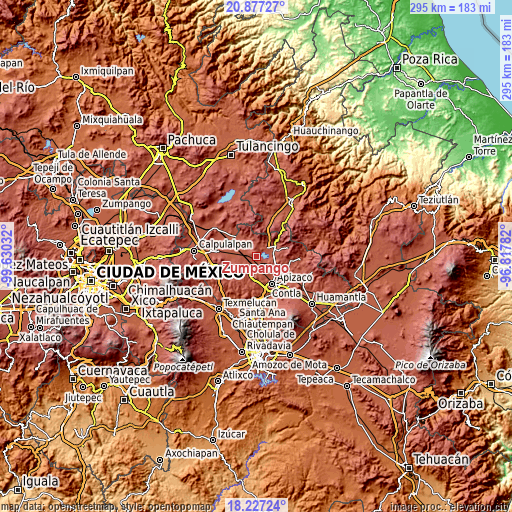
| \ | Map #1 | Topo.Map |
| Scale [m] | 2471..2895 m | × |
| Scale [ft] | 8107..9498 ft | × |
| Average | 2568.9 m = 8428 ft | × |
| Width | 9.21 km = 5.7 mi | 294.7 km = 183.1 mi |
| Height | 9.21 km = 5.7 mi | 294.7 km = 183.1 mi |
| ↑Max Latitude | 19.599105° | 20.87727° |
| Latitude at center | 19.5577° | 19.5577° |
| ↓Min Latitude | 19.516285° | 18.22724° |
| ← Min Longitude | -98.268015° | -99.63032° |
| Longitude center | -98.22407° | -98.22407° |
| →Max Longitude | -98.180125° | -96.81782° |
Nearby cities:
Cities around Zumpango sort by population:
• Tlaxco elevation 2550 m
12.6 km,  59°
59°
• San Simeón Xipetzingo 2638 m
11.2 km,  219°
219°
• San Lucas Tecopilco 2588 m
8.6 km,  202°
202°
• El Rosario 2704 m
11.5 km,  357°
357°
• Muñoz 2488 m
9.4 km,  170°
170°
• Lagunilla 2591 m
10.2 km,  328°
328°
• San Pedro Ecatepec 2590 m
8.3 km,  118°
118°
• San José Cuamantzingo 2498 m
5.6 km,  213°
213°
• José María Morelos 2511 m
12.3 km,  146°
146°
• San José Tepeyahualco 2560 m
6.6 km,  314°
314°
• San Lorenzo Sóltepec 2536 m
10.7 km,  298°
298°
• Atlangatepec 2507 m
3.3 km, 150°
Multilingual:
 En español:
Zumpango elevación 2605 m.
 En France:
Zumpango élévation 2605 m.
 Auf Deutsch:
Zumpango höhe über dem Meeresspiegel ist 2605 m.

Sources and notes:
- [note 1] Map square and city borders are not equal. Map elevation data is calculated only from area inside that square.
- [src 1] Elevation data from geonames database provided with same terms of usage.
- [src 2] The elevation map of Zumpango is generated using elevation data from NASA's 3 arcsec (90m) resolution SRTM data.
- [src 3] Base (background) map © OpenStreetMap contributors tiles are generated by Geofabrik and OpenTopoMap.
Copyright & License:
This Zumpango Elevation Map is licensed under CC BY-SA. You may reuse any part from this page, if you give a proper credit by linking to this URL:
 More info on terms of use page.