Zempoala elevation
Zempoala (Hidalgo), Mexico elevation is 2460 meters and Zempoala elevation in feet is 8071 ft above sea level [src 1]. Zempoala is a seat of a second-order administrative division (feature code) with elevation that is 1146 meters (3760 ft) bigger than average city elevation in Mexico.
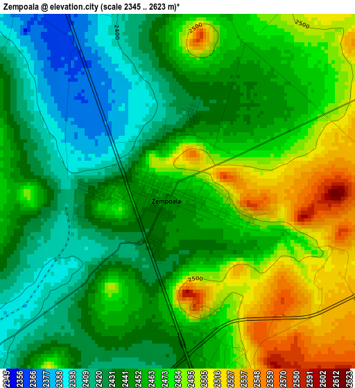
Below is the Elevation map of Zempoala, which displays elevation range with different colors. Scale of the first map is from 2345 to 2623 m (7694 to 8606 ft) with average elevation of 2457.5 meters (=8063 ft) [note 1]
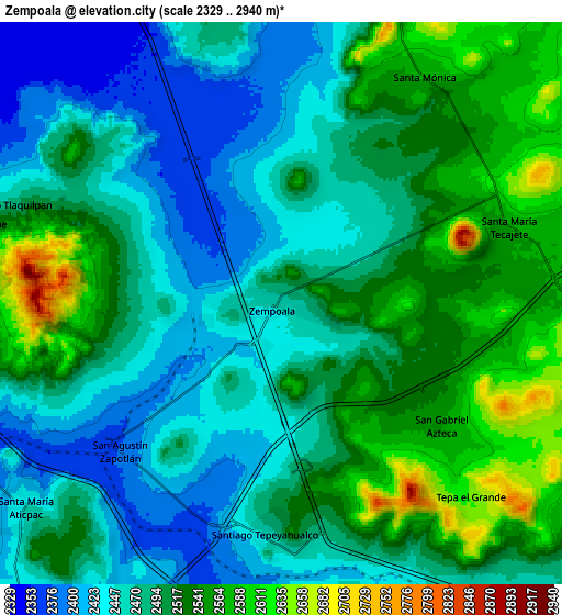
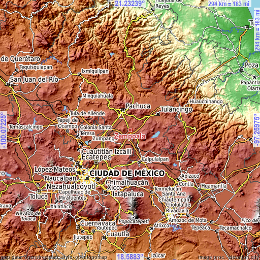
These maps also provides idea of topography and contour of this city, they are displayed at different zoom levels. More info about maps, scale and edge coordinates you can find below images.
| \ | Map #1 | Map #2 | Topo.Map |
| Scale [m] | 2345..2623 m | 2329..2940 m | × |
| Scale [ft] | 7694..8606 ft | 7641..9646 ft | × |
| Average | 2457.5 m = 8063 ft | 2493.9 m = 8182 ft | × |
| Width | 9.19 km = 5.7 mi | 18.38 km = 11.4 mi | 294 km = 182.7 mi |
| Height | 9.19 km = 5.7 mi | 18.38 km = 11.4 mi | 294 km = 182.7 mi |
| ↑Max Latitude | 19.957182° | 19.998483° | 21.23239° |
| Latitude at center | 19.91587° | 19.91587° | 19.91587° |
| ↓Min Latitude | 19.874547° | 19.833214° | 18.5883° |
| ← Min Longitude | -98.709945° | -98.753891° | -100.07225° |
| Longitude center | -98.666° | -98.666° | -98.666° |
| →Max Longitude | -98.622055° | -98.578109° | -97.25975° |
Nearby cities:
Cities around Zempoala sort by population:
• Tlanalapa elevation 2457 m
12.6 km,  149°
149°
• San Felipe Teotitlán 2457 m
12.9 km,  196°
196°
• Santa María Actipac 2450 m
10.7 km,  231°
231°
• Epazoyucan 2465 m
11.8 km,  15°
15°
• Santiago Tepeyahualco 2458 m
7.5 km,  182°
182°
• Santo Tomas 2655 m
10.3 km,  97°
97°
• San Pedro Tlaquilpan 2475 m
9.7 km,  289°
289°
• Santa Mónica 2571 m
8.9 km,  31°
31°
• Colonia Guadalupe 2477 m
10.7 km,  283°
283°
• San Agustín Zapotlán 2382 m
6.8 km, 228°
• La Trinidad 2386 m
6.7 km,  317°
317°
• San Gabriel Azteca 2562 m
6.5 km,  127°
127°
Multilingual:
 En español:
Zempoala elevación 2460 m.
 En France:
Zempoala élévation 2460 m.
 Auf Deutsch:
Zempoala höhe über dem Meeresspiegel ist 2460 m.

Sources and notes:
- [note 1] Map square and city borders are not equal. Map elevation data is calculated only from area inside that square.
- [src 1] Elevation data from geonames database provided with same terms of usage.
- [src 2] The elevation map of Zempoala is generated using elevation data from NASA's 3 arcsec (90m) resolution SRTM data.
- [src 3] Base (background) map © OpenStreetMap contributors tiles are generated by Geofabrik and OpenTopoMap.
Copyright & License:
This Zempoala Elevation Map is licensed under CC BY-SA. You may reuse any part from this page, if you give a proper credit by linking to this URL:
 More info on terms of use page.