Epazoyucan elevation
Epazoyucan (Hidalgo), Mexico elevation is 2465 meters and Epazoyucan elevation in feet is 8087 ft above sea level [src 1]. Epazoyucan is a seat of a second-order administrative division (feature code) with elevation that is 1151 meters (3776 ft) bigger than average city elevation in Mexico.
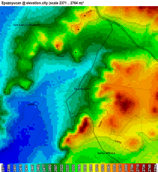
Below is the Elevation map of Epazoyucan, which displays elevation range with different colors. Scale of the first map is from 2371 to 2764 m (7779 to 9068 ft) with average elevation of 2526.4 meters (=8289 ft) [note 1]
These maps also provides idea of topography and contour of this city, they are displayed at different zoom levels. More info about maps, scale and edge coordinates you can find below images.
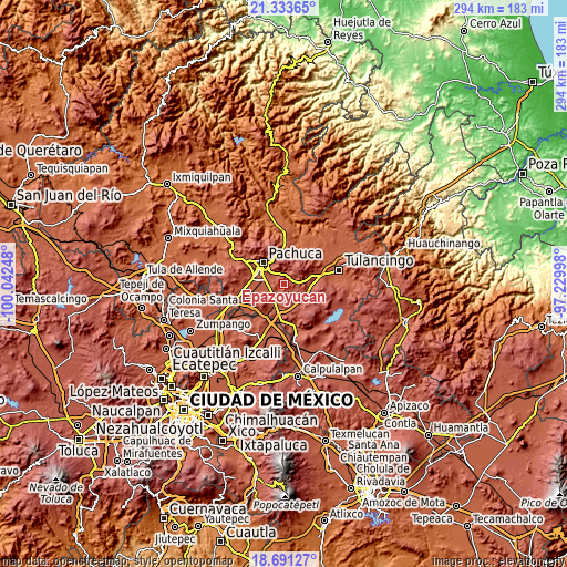
| \ | Map #1 | Topo.Map |
| Scale [m] | 2371..2764 m | × |
| Scale [ft] | 7779..9068 ft | × |
| Average | 2526.4 m = 8289 ft | × |
| Width | 9.18 km = 5.7 mi | 293.8 km = 182.6 mi |
| Height | 9.18 km = 5.7 mi | 293.8 km = 182.6 mi |
| ↑Max Latitude | 20.059295° | 21.33365° |
| Latitude at center | 20.01801° | 20.01801° |
| ↓Min Latitude | 19.976714° | 18.69127° |
| ← Min Longitude | -98.680175° | -100.04248° |
| Longitude center | -98.63623° | -98.63623° |
| →Max Longitude | -98.592285° | -97.22998° |
Nearby cities:
Cities around Epazoyucan sort by population:
• La Providencia Siglo XXI elevation 2391 m
9.9 km,  301°
301°
• Pachuquilla 2427 m
8.6 km,  313°
313°
• Colinas de Plata 2426 m
11.6 km, 305°
• El Saucillo (Fraccionamiento) 2394 m
11.4 km, 298°
• Rinconada de los Ángeles 2364 m
7.9 km,  276°
276°
• Carboneras 2454 m
10.8 km,  317°
317°
• Santa Mónica 2571 m
4.1 km,  157°
157°
• Santa María la Calera 2362 m
8.8 km, 279°
• San Juan Tizahuapán 2470 m
4.7 km, 320°
• Privada del Álamo 2455 m
11.2 km, 323°
• Xolostitla de Morelos (Xolostitla) 2478 m
5.4 km,  357°
357°
• La Trinidad 2386 m
10 km,  229°
229°
Multilingual:
 En español:
Epazoyucan elevación 2465 m.
 En France:
Epazoyucan élévation 2465 m.
 Auf Deutsch:
Epazoyucan höhe über dem Meeresspiegel ist 2465 m.

Sources and notes:
- [note 1] Map square and city borders are not equal. Map elevation data is calculated only from area inside that square.
- [src 1] Elevation data from geonames database provided with same terms of usage.
- [src 2] The elevation map of Epazoyucan is generated using elevation data from NASA's 3 arcsec (90m) resolution SRTM data.
- [src 3] Base (background) map © OpenStreetMap contributors tiles are generated by Geofabrik and OpenTopoMap.
Copyright & License:
This Epazoyucan Elevation Map is licensed under CC BY-SA. You may reuse any part from this page, if you give a proper credit by linking to this URL:
 More info on terms of use page.