Colinas de Plata elevation
Colinas de Plata (Hidalgo, Mineral de la Reforma), Mexico elevation is 2426 meters and Colinas de Plata elevation in feet is 7959 ft above sea level [src 1]. Colinas de Plata is a populated place (feature code) with elevation that is 1112 meters (3648 ft) bigger than average city elevation in Mexico.
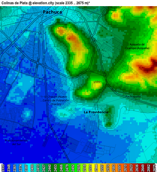
Below is the Elevation map of Colinas de Plata, which displays elevation range with different colors. Scale of the first map is from 2335 to 2675 m (7661 to 8776 ft) with average elevation of 2408.2 meters (=7901 ft) [note 1]
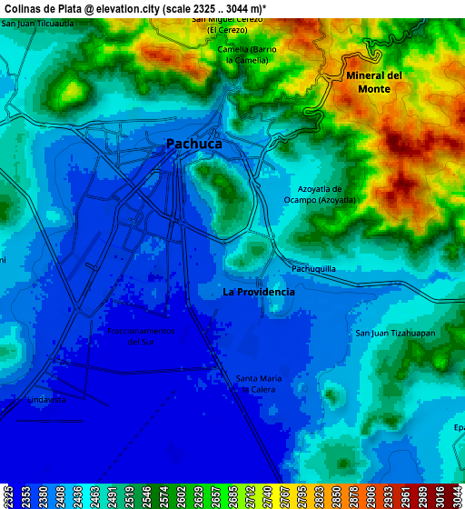
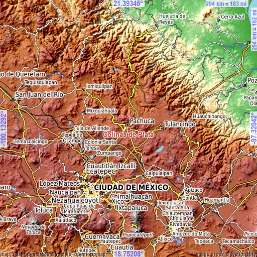
These maps also provides idea of topography and contour of this city, they are displayed at different zoom levels. More info about maps, scale and edge coordinates you can find below images.
| \ | Map #1 | Map #2 | Topo.Map |
| Scale [m] | 2335..2675 m | 2325..3044 m | × |
| Scale [ft] | 7661..8776 ft | 7628..9987 ft | × |
| Average | 2408.2 m = 7901 ft | 2482.5 m = 8145 ft | × |
| Width | 9.18 km = 5.7 mi | 18.36 km = 11.4 mi | 293.7 km = 182.5 mi |
| Height | 9.18 km = 5.7 mi | 18.36 km = 11.4 mi | 293.7 km = 182.5 mi |
| ↑Max Latitude | 20.119599° | 20.160857° | 21.39345° |
| Latitude at center | 20.07833° | 20.07833° | 20.07833° |
| ↓Min Latitude | 20.03705° | 19.995759° | 18.75208° |
| ← Min Longitude | -98.770615° | -98.814561° | -100.13292° |
| Longitude center | -98.72667° | -98.72667° | -98.72667° |
| →Max Longitude | -98.682725° | -98.638779° | -97.32042° |
Nearby cities:
Cities around Colinas de Plata sort by population:
• La Providencia Siglo XXI elevation 2391 m
1.9 km,  147°
147°
• Campestre Villas del Álamo 2429 m
3.3 km,  38°
38°
• Pachuquilla 2427 m
3.3 km,  104°
104°
• Unidad Minera 11 de Julio 2420 m
3 km,  7°
7°
• El Saucillo (Fraccionamiento) 2394 m
1.3 km,  205°
205°
• PRI Chacón 2375 m
1.1 km,  287°
287°
• El Saucillo 2375 m
1.1 km,  262°
262°
• Santiago Jaltepec 2441 m
3.8 km,  24°
24°
• Carboneras 2454 m
2.6 km,  59°
59°
• Nuevo Centro de Población Agrícola el Chacón 2364 m
1.6 km,  236°
236°
• Privada del Álamo 2455 m
3.5 km,  51°
51°
• San Cristóbal Chacón 2393 m
0.7 km, 288°
Multilingual:
 En español:
Colinas de Plata elevación 2426 m.
 En France:
Colinas de Plata élévation 2426 m.
 Auf Deutsch:
Colinas de Plata höhe über dem Meeresspiegel ist 2426 m.

Sources and notes:
- [note 1] Map square and city borders are not equal. Map elevation data is calculated only from area inside that square.
- [src 1] Elevation data from geonames database provided with same terms of usage.
- [src 2] The elevation map of Colinas de Plata is generated using elevation data from NASA's 3 arcsec (90m) resolution SRTM data.
- [src 3] Base (background) map © OpenStreetMap contributors tiles are generated by Geofabrik and OpenTopoMap.
Copyright & License:
This Colinas de Plata Elevation Map is licensed under CC BY-SA. You may reuse any part from this page, if you give a proper credit by linking to this URL:
 More info on terms of use page.