Bestobe elevation
Bestobe (Aqmola), Kazakhstan elevation is 174 meters and Bestobe elevation in feet is 571 ft above sea level [src 1]. Bestobe is a populated place (feature code) with elevation that is 184 meters (604 ft) smaller than average city elevation in Kazakhstan.
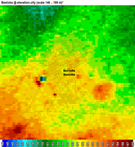
Below is the Elevation map of Bestobe, which displays elevation range with different colors. Scale of the first map is from 146 to 189 m (479 to 620 ft) with average elevation of 169.7 meters (=557 ft) [note 1]
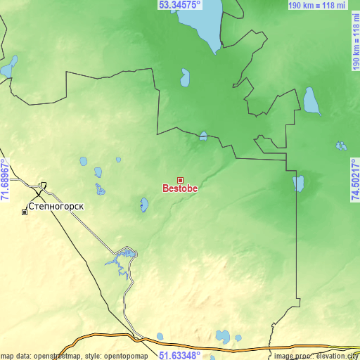
These maps also provides idea of topography and contour of this city, they are displayed at different zoom levels. More info about maps, scale and edge coordinates you can find below images.
| \ | Map #1 | Map #2 | Topo.Map |
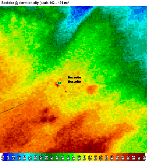
| Scale [m] | 146..189 m | 142..191 m | × |
| Scale [ft] | 479..620 ft | 466..627 ft | × |
| Average | 169.7 m = 557 ft | 168.6 m = 553 ft | × |
| Width | 5.95 km = 3.7 mi | 11.9 km = 7.4 mi | 190.4 km = 118.3 mi |
| Height | 5.95 km = 3.7 mi | 11.9 km = 7.4 mi | 190.4 km = 118.3 mi |
| ↑Max Latitude | 52.524695° | 52.551424° | 53.34575° |
| Latitude at center | 52.49795° | 52.49795° | 52.49795° |
| ↓Min Latitude | 52.471188° | 52.444411° | 51.63348° |
| ← Min Longitude | 73.051975° | 73.008029° | 71.68967° |
| Longitude center | 73.09592° | 73.09592° | 73.09592° |
| →Max Longitude | 73.139865° | 73.183811° | 74.50217° |
Nearby cities:
Cities around Bestobe sort by population:
• Ekibastuz elevation 203 m
174.7 km,  119°
119°
• Stepnogorsk 311 m
83.9 km,  258°
258°
• Makinsk 380 m
181.5 km,  274°
274°
• Yermentau 392 m
97.2 km,  179°
179°
• Aksu 278 m
77.3 km, 265°
• Shortandy 375 m
168.8 km,  238°
238°
• Zholymbet 329 m
126.4 km,  228°
228°
• Kzyltu 135 m
136.2 km,  338°
338°
• Zavodskoy 264 m
73.2 km, 267°
• Stepnyak 366 m
160 km,  283°
283°
• Talshik 75 m
150.7 km,  327°
327°
• Akkol 381 m
156.7 km,  249°
249°
Multilingual:
 En español:
Bestobe elevación 174 m.
 En France:
Bestobe élévation 174 m.


Sources and notes:
- [note 1] Map square and city borders are not equal. Map elevation data is calculated only from area inside that square.
- [src 1] Elevation data from geonames database provided with same terms of usage.
- [src 2] The elevation map of Bestobe is generated using elevation data from NASA's 3 arcsec (90m) resolution SRTM data.
- [src 3] Base (background) map © OpenStreetMap contributors tiles are generated by Geofabrik and OpenTopoMap.
Copyright & License:
This Bestobe Elevation Map is licensed under CC BY-SA. You may reuse any part from this page, if you give a proper credit by linking to this URL:
 More info on terms of use page.